
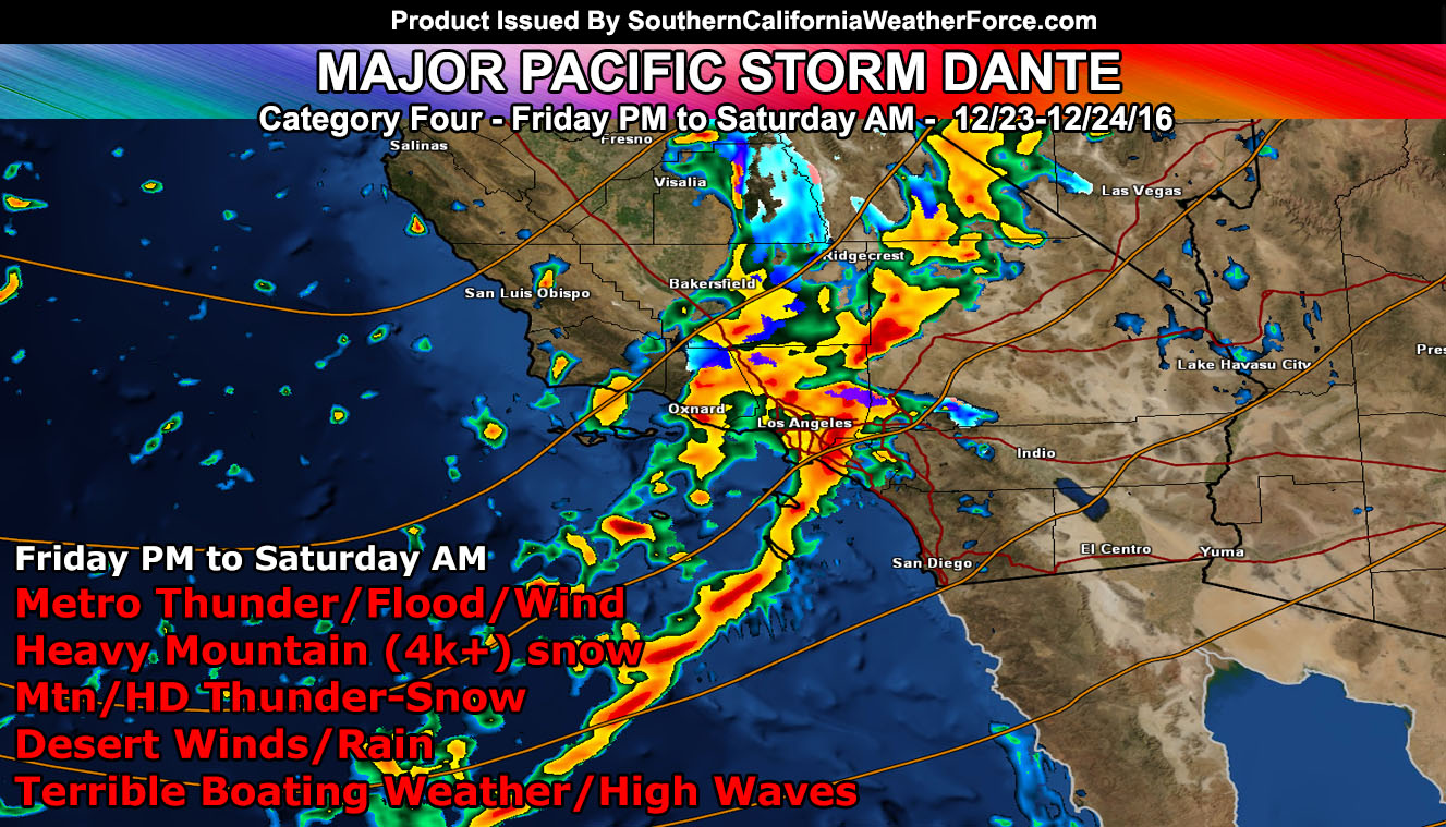
Major Pacific Storm Dante is impacting Southern California through tonight and Saturday morning and he’ll pack a powerful punch in various areas so read on for details.
Upgraded the Blizzard Watches in the mountains to a Blizzard Warning for the Ventura, Los Angeles, San Bernardino, and Riverside Mountains above 4,000 FT.
Snow levels in the warning areas should generally be around 5,000 FT to start, pushing slightly up tonight to 5,700 FT with slight warm air advection in play … then crash below 4,000 FT after 3am Saturday morning with light snow continuing at times behind the front …
Heavy snowfall is expected with this along with gusty winds in the warning area … thus whiteout conditions are possible along with the risk of thundersnow. Select area snow amounts based on my custom model shows the following;
Mt. Pinos: 15 – 22″
Wrightwood: 6 – 12″
Cajon Pass: 1 – 3″
Crestline: 4 – 8″
Lake Arrowhead: 12 – 18″
Snow Valley Resort: 12 – 18″
Big Bear Lake West: 12- 15″
Big Bear Lake East: 8 – 12″
Idyllwild: 9 – 14″
Anza: 2 – 5″
Palm Springs Tramway: 12 – 18″
NOTE: If you are a premium member you can view the snow level and snow model information with timings included.
Click Here To Enter The Member Section
Issued a Snow Advisory for the Gorman Pass and all areas of the Kern County Mountains above 4,000 FT.
The snow level will start out this evening just below 6,000 FT with heavy snowfall, dropping early tonight to 4,500 FT with wet snow through 3,500 FT and remaining heavy … which will put the snow in the Tehachapi and Gorman Pass regions … easily. Gusty winds will accompany the storm.
Light snowfall may continue off and on through Saturday with a snow level just below 3,000 FT …
Predicted amounts via my model …
Pine Mountain Club: 4 – 8″
Gorman Pass: 4 – 8″
Tehachapi: 3 – 5″
Bear Valley Springs: 12″+
NOTE: If you are a premium member you can view the snow level and snow model information with timings included.
Click Here To Enter The Member Section
Flood Watches will remain in effect for all areas south and west of the mountains where I don’t see where a good 1-2″ of rain is possible in most areas.
Thunderstorms are being watched for at the moment. Do feel that as the lifting source in the mid-levels comes in overnight tonight we’ll see lightning in the forecast area, mainly the metro areas .. with some possible along the mountains as well for thundersnow risks. At the current time am monitoring the lightning strike data to see if there are any strikes detected offshore. Upgraded alerts could be needed in the micro-climate alert system, posted to the micro-climate Facebook groups and Android devices.
Gusty winds in all areas will be felt … some already reporting the southerly winds in the mtn/des areas .. .and along the coast. These winds will be over advisory level for the metro areas into Saturday behind the front …
HIGH DESERT: Your area is being monitored from around Lake Los Angeles along the I-15 corridor through the Apple/Lucerne Valley forecast areas for the risk of snowfall … possibly even more than just a dusting as the end of the front merges with the backdoor cold front toward the end of the storm just before sunrise on Saturday morning. If this continues to be possible … winter alerts will be issued for you tonight before 9pm …
Everyone else is going to have to click the link and go to your micro-climate section and await the alerts that come. Some are out now … and others will be issued.
Click Here To Go To Your Micro-Climate Section –
Full Members can see the snow level, snow amount, flood risk, rainfall maps, by tomorrow morning before Dante hits … Don’t miss out! … Click Here To Enter the Member Section
See ALL the alerts I issue here – http://www.southerncaliforniaweatherforce.com/