
Given this is a strong cutoff low and has some upper jet features with it, it’ll be3 highly unstable in tracking so the forecasts will be issued in short range, such as what is happening today through tonight. Some areas with wind, some rain, some thunderstorms, and some severe thunderstorms. Find out the details by reading on …
The system is approaching the area and up-sloping activity common with such a system is being felt across the coast/valley areas in the form of lighter rainfall. The Planes Of Fame Airshow in Chino is underway and they will also have showers passing through today.
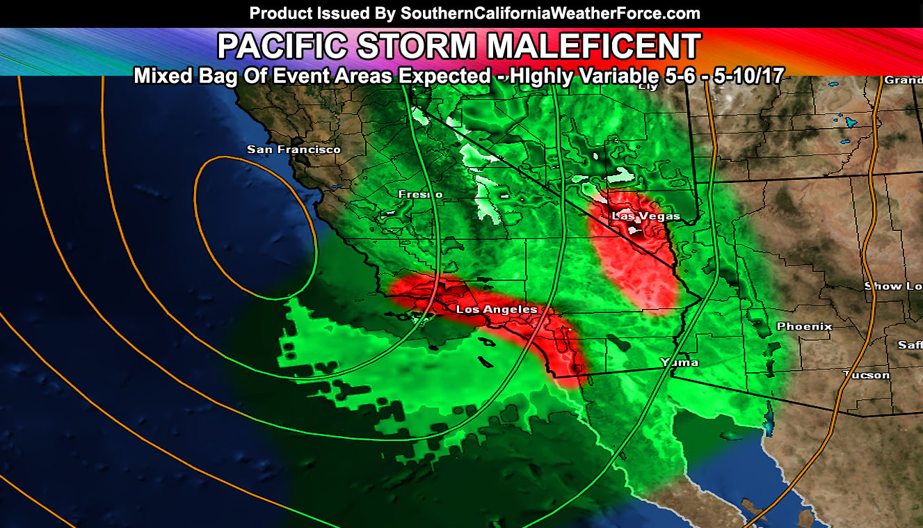
Key areas that will be watched that will be the first activity to pop in the region will be the Pine Mountain Club and Eastern San Bernardino County Desert areas.
Already I have issued a Thunderstorm Watch for thew Pine Mountain Club area. Short range modeling continues to show snow levels at 6,000 FT … however with the evening storms I expect to form I do think this will be a bit lower than numbers say so heck you could see the flakes fly in town. Given this, thunderstorms with snowfall would make it thundersnow. This will continue through tonight.
That batch of precipitation will move westward on the northern periphery of the system and into the Santa Barbara County zones tonight, dipping southward as well around the western periphery of the system, hitting Downtown Santa Barbara/Ventura. The backside of the system would bring another area of divergence through San Luis Obispo and Santa Barbara County later tonight and very early Sunday morning before sunrise.
Now, this evening another area is along the I-40 and I-15 travel zones east of Ludlow and Baker. These zones into and out of Needles and Las Vegas, NV will be a target area for severe thunderstorms. For this I have issued the Severe Thunderstorm Watch for those zones. A strong cutoff low will enter the region this evening, putting the Eastern San Bernardino County Deserts within the strong upper divergent section of the low. Slightly warmer low levels and advancing cold air in the mid-levels will steepen the instability parameters and pop off thunderstorms in the region this evening.The movement of the storms will be fairly quick to the east. Highest impact will be along I-40 near the Essex/Fenner regions this evening … Damaging winds are possible with this … as well as hail up to the size of 1″ in diameter. Tornado values are extremely low .. but with all severe thunderstorm watches they can and sometimes do form so the chance is there.
LIKE US ON FACEBOOK for updates! Click Here and join thousands …
Now as that area moves out, the metro zones of Orange and San Diego County would be next as onshore flow steepens with instability and upper divergence, turning these light showers today into heavy rainfall producing cells … with a chance of thunder. For the Western half of San Diego County, including Downtown San Diego, I have issued my Flood Advisory for 1-3″ of rainfall …
The northern axis of the moisture plume looks to cutoff in Los Angeles County, so I’m expecting less of coverage overnight in those areas, as well as far Central/Eastern/Northern Inland Empire zones, giving the 91 Freeway southward as a cutoff for more numerous activity to be and areas north of there with spotty activity.
Snowfall for the Big Bear Lake areas will wait until Sunday as deeper-layer moisture moves in. Snow amounts would vary across the mountain… but a good thunderstorm could bring you over 6″ of snowfall in spots at the snow level with over 8-10″ above 7,500 FT. Of course on Sunday the 8,500 FT mark of the Palm Springs Aerial Tramway would be well above the snow-level .. .thus over a foot of snow is likely up there. Got passes? Head on up … The wind should be much calmer than on Saturday with a gentle non-blizzard snow falling on Sunday as a result of the upper level system being directly overhead.
On Sunday, the backside of the system hits the VT/LA/OC/IE/SD areas, including some activity popping in the metro High Desert areas … and tracking of this will continue with updates through the system.
waterspouts land-falling as small tornadoes are also possible through the entire event …
Imperial County, you can expect your rainfall to happen on Sunday into Sunday night …
Stay tuned to Southern California Weather Force …
Members, Click Here To Enter Your Member Section for precip maps …
Non-members, choose your micro-climate Facebook group – https://www.southerncaliforniaweatherforce.com/scwf-weather-alert-facebook-groups-by-region/