
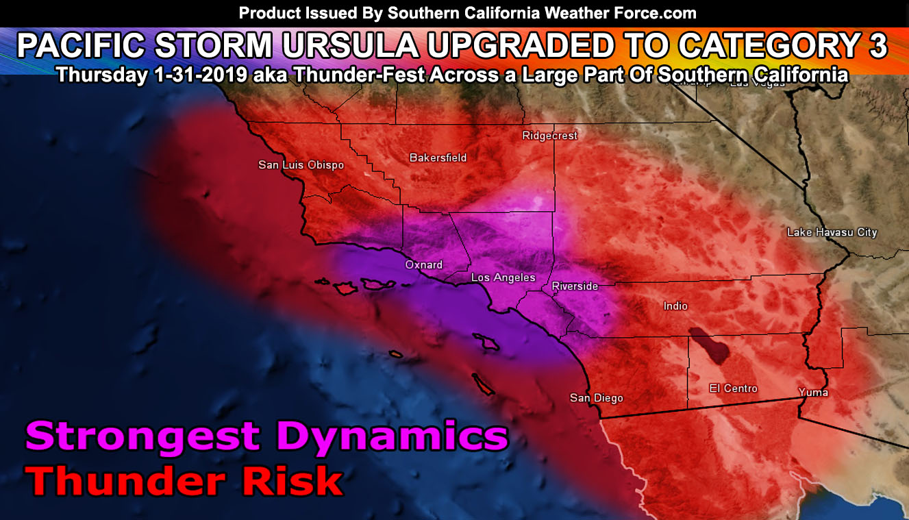
Pacific Storm URSULA has been upgraded here at the Southern California Weather Force to a Category Three System. A category three with a heavy frontal zone, breeze conditions on the front but not damaging, and numerous thunderstorms. It’ll hit the forecast area on your Thursday so for locations and timing read on …
A Flood Advisory was issued just before 10am here at Southern California Weather Force for; San Luis Obispo, Santa Barbara, Los Angeles, Orange County … San Diego Coast/Valley … Kern Edwards/Mojave/Valleys/Tehachapi/Frazier/PMC … The Inland Empire … Southern High Desert around Hesperia …
A ‘punch in the face’ type system or so I call it will enter the SLO / Vandenberg zones after midnight tonight and go through Ventura/Kern early Thursday morning, finally entering Los Angeles, OC/SD/IE/HD later morning into early afternoon. This will have a strong upper divergent pattern so in no doubt do I think this will be a light rain event in the advisory area. This should bring a very large zone of over an inch of rainfall to the advisory area, the exception being San Diego proper with less rainfall. SCWF Flood Risk Model has a large area of moderate risk in the advisory zone with some ‘high risk’ in the LA Basin. There is a high risk of thunderstorms in a large part of this advisory area and a thunderstorm watch may be needed if time permits so look for it. Full members can see the flood risk model below in their member section but you can hit the image to zoom-in if you want…
A punch in the face system is pretty rare for here. I believe the last one was over 6 years ago almost the same time-frame as this one. A punch in the face system is a term I use for a very potent and compact upper level low that has strong upper divergence in a small but compact area of the frontal zone that moves fast across the forecast area delivering numerous thunderstorms and torrential downpours. Such a system is URSULA, the sea-witch. I mean it really means little or she-bear, however sea witch is just more fun to say as we all know the movie.
Going to go with select timings on snow levels over the Kern Mountains at 6,600 FT along the front with wet snow to 5,600. Big Bear will have over 7,000 FT snow levels with the bulk of the moisture ending in the aftenroon with 6,300 FT snow levels with any left-over post-frontal showers. This is not a Cajon or Gorman Pass affecting system.
Other such timeframes will be the following; Effective for Thursday 1-31-2019
San Luis Obispo / Vandenberg – 1am
Santa Barbara – 7am
Ventura – 8am
Bakersfield – 9am
Los Angeles – 10am
OC/IE 12pm
High Desert – 1pm
San Diego – 3pm
Morongo Basin / Palm Springs – 5-6pm
Imperial County – Desert Center – 6-7pm
One thing to note is that I will need to monitor the low deserts for the chance of thunderstorms as this does have instability and lift along with the moisture way out there so I’ll have plenty of time to refine the forecast on Thursday as the metros are being hit.
The next system is a much larger and more long duration system over the weekend, which could be Major Pacific Storm Vladimir due to the flooding if it holds. This system however looks weaker for thunderstorms on the frontal zone than Pacific Storm URSULA so if you like thunderstorms then Thursday is the better one to have.
We continue this pattern off and on for awhile so click here for that article
End
NOTE: Premium members. If you are signed up, your login is your e-mail address and the username and password as the password. You can change the password
Ongoing Ad – The Southern California Weather Force has a member section with LIVE UPDATES FOR EVENTS and rain, wind, thunder, tornado etc models that are personally updated by me with each Santa Ana Wind or storm event. You also can get e-mailed alerts via a slew of micro-climates. Check the member section for details on how you can support this service.. along with getting service in return… Click Here To Join or Upgrade Via The Member Section
Please remember if upgrading to CANCEL YOUR PAYPAL PAYMENTS. Login and cancel the reoccurring payments.
The Southern California Weather Force has different Facebook groups that you can ask for notifications from in order to get the latest posts affecting those regions. If that area is talked about in an article, alert, and such .. it’ll be posted there and you can be notified.
Comments are usually DISABLED as we do like to keep this as an information giving group and replies from others in the notification may annoy some.
Find your micro-climate group here – https://www.southerncaliforniaweatherforce.com/scwf-weather-alert-facebook-groups-by-region/
EMAIL ALERTS? Many micro-climate zones to choose from to get custom alerts from thunderstorm, wind, flood, surf, heat, cold, storm, and much more with the premium e-mail alert system, the most advanced zone alert system in Southern California – Click Here To Join!
SOUTHERN CALIFORNIA ONLY: if it does not say “Liked” LIKE The Page Below and join thousands of informed weather forecast viewers in our region for more of the updates! noticeable
BEHIND THE SCENES FORECASTS/UPDATE PAGE: if it does not say “Liked” LIKE The Page Below and join thousands of informed weather forecast viewers in our region for more of the updates! noticeable