
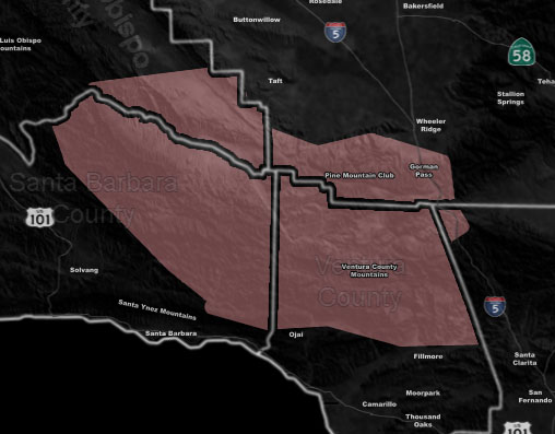
Issued Zones: Santa Barbara/Ventura Mountains… Kern Mountains PMC/Cuddy Valley …
Site: Southern California Weather Force has issued a Thunderstorm Watch effective now through Monday …
Date: 4/28/19 at 10:16 pm PT
Forecast: cutoff system to the southwest and south of the region will bring upper divergence into play today. This upper divergence will bring with it the higher later April sun-angle for instability to be elevated and thus with increasing moisture this afternoon we will begin to see thunderstorm activity in the watch area.
Thunderstorm dynamics will continue through the night into Monday with increased activity expected as the flow turns from east to west to north to south and creates the perfect convergence boundary in the watch zones. Hail and gusty winds will be likely with this.
The inverted-V profiles are soundings indicated marginal severe storm activity will be possible with this event. Expect activity to diminish by Monday evening …
EMAIL ALERTS: Get these to your e-mail by upgrading to a full member. It pays for itself in just ONE weather event: Click Here To Learn More
Additional Models: Visit the main site to see what was updated in terms of rain/snow/flood risk and more – Click Here
Join A Micro-Climate Group On Facebook For These Alerts – Click Here To Find Your Location Served By SCWF Today!
10-mile rule: These alerts issued on this site means that within your zone and 10 miles from you will see the event forecast for. You may or may not see the event but it means you are in the zone or 10 miles from where someone will.
Forecaster: KM