
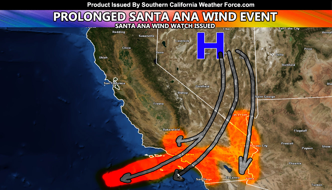
Southern California Weather Force has issued the Santa Ana Wind Watch effective now for Thursday through Friday of this next week. The Santa Ana Wind Event will be the first stronger event of the system based off the scientific pattern and it will be generated by two out of the three ingredients, so a 60% completion of ingredients needed for these events.
Confidence is high that when a deep Pacific trough moves into the Western United States by Tuesday for the Rockies and Wednesday for the Dakotas that cold air behind it will develop a strong surface high pressure system over the Great Basin. This will be the thermal support needed. The second ingredient will be the gradient support as this developing surface high will be strong enough to work with lowering heights over the bight of Southern California, sending the winds into the area. The current estimation this far out in the 5-day medium range period is around 50 mph in the prone locations.
NOTE: TIME IS RUNNING OUT. IF THIS TROUGH GETS A NAME THEN THE DISCOUNT WILL HAVE ENDED… If you have renewed your discounted MICRO-CLIMATE E-MAIL ALERT SYSTEM membership for the 2019-2020 season, skip this message. If you have not, Click Here To Renew. This will be one of your last e-mailed article/alert from the 2019-2020 season as effective now the season will start when the first named storm system enters the region so don’t wait. Click Here To Renew Under The Discount.
The wind will be strongest on Thursday for the Santa Clarita/Ontario/Tehachapi/Colorado River Valley/Morongo Valley areas and maintain strength with Banning/San Diego to Riverside Mountains entering into the mix by Friday as the flow turns more east-northeasterly and opens up those locations. This is a prolonged event pattern lasting more than 36-48 hours and it will accompany warm temperatures, but nothing like 100F. This will have temperatures in the 80s and 90s with low humidity levels and thus this Santa Ana Wind Watch I am issuing is officially a Fire Weather Watch hazard forecast.
Stay tuned to Southern California Weather Force for more information as I crunch my numbers.
As always, stay tuned to official forecasts from Southern California Weather Force for updates …
For The Main Weather Facebook Page Click Here and Join.
End Article
OPTIONAL: Southern California Weather Force main page now has models, agendas, the alert map, and other things updated during storm events. You can bookmark the main site and check back during an event for the latest updates.
Click here to view the main page
EMAIL ALERTS AND ASK THE WEATHER OFFICE A QUESTION: It pays for itself in one storm system. A very affordable e-mail alert system that only gives you SCWF weather alerts in YOUR micro-climate area. Also, you can ask the weather office a question at any time if you get that add-on.
Click here to join
MICRO-CLIMATE ALERT FACEBOOK GROUPS: Find yours today!
Click here to join
FACEBOOK PAGES TO JOIN!
SOUTHERN CALIFORNIA WEATHER FORCE MAIN: Southern California Weather Force Office Main Page
BEHIND THE SCENES FORECASTS/UPDATE PAGE: Southern California Weather Force Meteorologist Page
FOR THE CALIFORNIA FAULT STRESS MODEL PAGE: For SCWF official updates to the California Fault Stress Model and more!
“PONDER THIS” SCIENCE ADVENTURE SHOW: A science adventure show developed here at Southern California Weather Force that is a fun ride!
INSTAGRAM AND TWITTER ACCOUNTS TO JOIN!
Instagram – https://www.instagram.com/socalweatherforce/
Twitter – https://twitter.com/SCweatherforce