
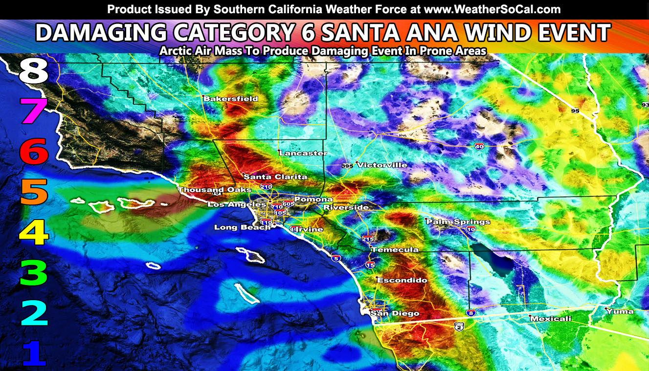
An arctic air mass settling into the Western United States will bring cold temperatures in wind sheltered areas along with strong Santa Ana Winds Tuesday evening through Thursday at 9pm with Santa Clarita at Category 6 for Santa Ana Winds, which are DAMAGING, with the cold lasting through till Friday morning. Read on for details and remember all images in the article are clickable as Southern California Weather Force is the only place that has a Santa Ana Wind Forecast Intensity Model and it can vary even 10 miles away from a point.
NOTE: ALL Articles AND Videos posted on Southern California Weather Force main Facebook Page are charity events. Anyone sharing will be entered into a list and one person will be randomly selected to get cash for causes. This started on in October 2019 and SCWF has donated $1750 to date of this article and counting. … So share away.. the more shares on Facebook, the more help can be done for the community and it costs you nothing.
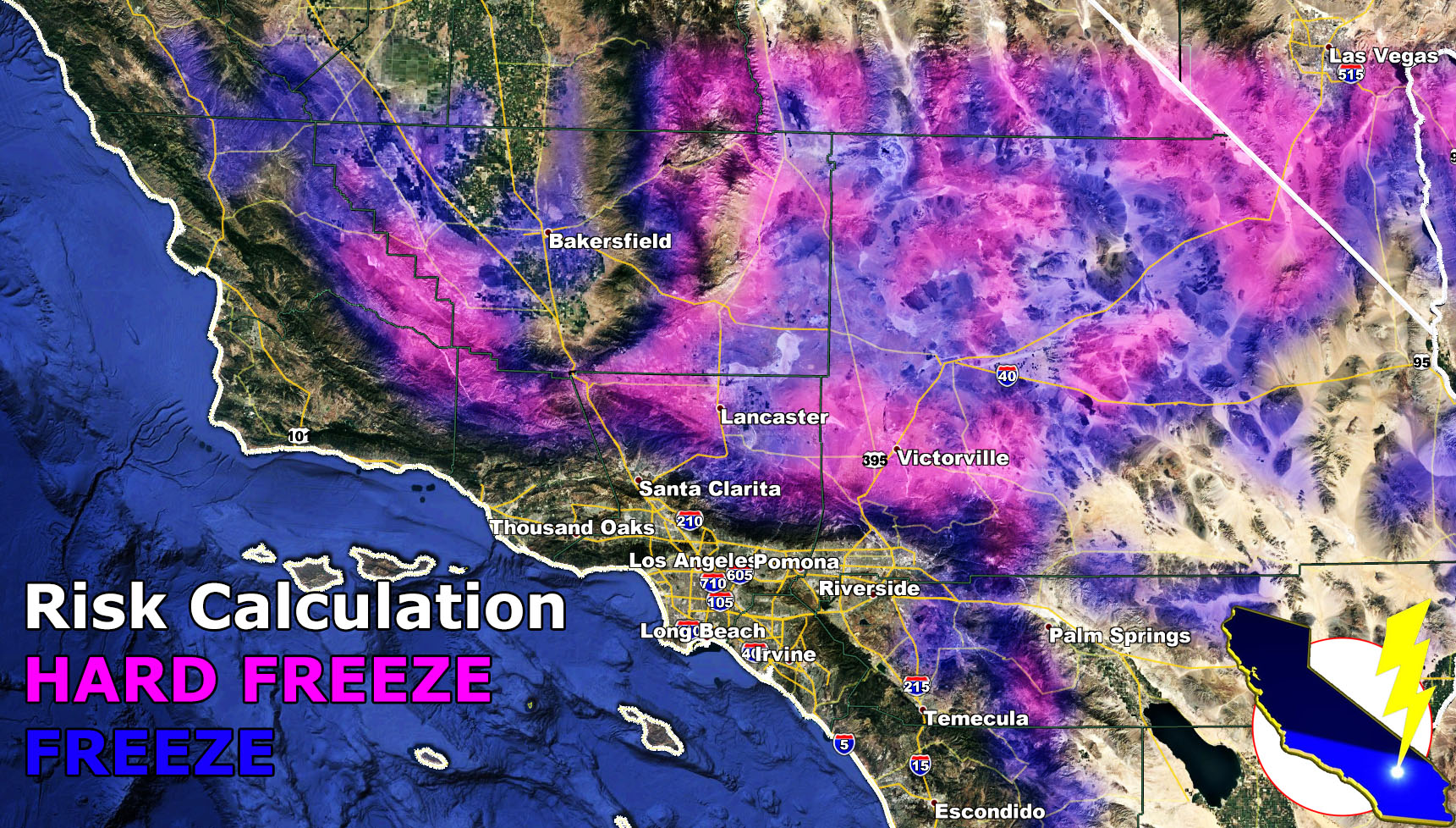
Last night wasn’t what you would call cold in the High Desert Metro areas. Freeze Watches are now officially in effect here at Southern California Weather Force for the entire High Desert areas, minus the Colorado River Valley. The freeze watch alert (Click here to read), reads;An arctic air mass is set to hit the Western United States over the Rocky Mountains Tuesday through Friday morning and this will bring an offshore wind pattern into the area. This cold air advecting in from the Great Basin will bring temperatures in the entire Freeze Warning area to 32 and below. There is a very good chance a Hard Freeze will set-up for some High Desert areas, but most certainly the High Desert populated metro zones of the Victor Valley and Lancaster. Please use the SCWF model below to find your area’s concern. Remember, a Hard Freeze means that you need to take your home/business piping precautions.
Use this image for your area! (Clickable)
As for the Santa Ana Winds. I issued a Power Disruption Watch yesterday for the prone areas. Expect your power to go off if that is NOW the norm for you, sadly. That is something I cannot control, however I did crack the electric company’s algorithm to produce such an alert and model. There is a category 6 Santa Ana Wind Event looming for the Santa Clarita and Ventura County Basin/Coast as well as the Fontana areas below the Cajon Pass Tuesday night into Wednesday at 4pm. The rest of you have high winds in the original prone zones to the Santa Ana Wind Pattern and I have produced the model for it using the Martin Wind Gust Intensity Scale. A Category 6 Santa Ana Wind Event is damaging as well as a Category 5 value. If you live in those zones on my model, prepare now. A category 4-5 is expected in Rosarito, MX as well. Gusty winds are not expected in Ensenada. The strongest winds will fade by Wednesday at 4pm, however a light/moderate wind event will remain blowing in the prone zones till Halloween night at 9pm.
Martin Wind Gust Intensity Scale –
8. Extensive widespread damage.
7. Trees are broken or uprooted, building damage is considerable.
6. SOME Trees are broken or uprooted, building damage is possible.
5. Slight damage occurs to buildings, shingles are blown off of roofs. HIGH WIND WARNING CRITERIA
4. Twigs and small branches are broken from trees, walking is difficult.
3. Large trees sway, becoming difficult to walk. POWER SHUTDOWN THRESHOLD WIND ADVISORY CRITERIA
2. Large tree branches move, telephone wires begin to “whistle”, umbrellas are difficult to keep under control.
1. Small trees sway.
Use this image for your area! (Clickable)
MICRO-CLIMATE ALERT FACEBOOK GROUPS: Find yours today!
Click here to join
NOTE: TIME IS RUNNING OUT. IF THIS TROUGH GETS A NAME THEN THE DISCOUNT WILL HAVE ENDED… If you have renewed your discounted MICRO-CLIMATE E-MAIL ALERT SYSTEM membership for the 2019-2020 season, skip this message. If you have not, Click Here To Renew. This will be one of your last e-mailed article/alert from the 2019-2020 season as effective now the season will start when the first named storm system enters the region so don’t wait. Click Here To Renew Under The Discount.
As always, stay tuned to official forecasts from Southern California Weather Force for updates …
For The Main Weather Facebook Page Click Here and Join.
End Article
OPTIONAL: Southern California Weather Force main page now has models, agendas, the alert map, and other things updated during storm events. You can bookmark the main site and check back during an event for the latest updates.
Click here to view the main page
EMAIL ALERTS AND ASK THE WEATHER OFFICE A QUESTION: It pays for itself in one storm system. A very affordable e-mail alert system that only gives you SCWF weather alerts in YOUR micro-climate area. Also, you can ask the weather office a question at any time if you get that add-on.
Click here to join
MICRO-CLIMATE ALERT FACEBOOK GROUPS: Find yours today!
Click here to join
FACEBOOK PAGES TO JOIN!
SOUTHERN CALIFORNIA WEATHER FORCE MAIN: Southern California Weather Force Office Main Page
BEHIND THE SCENES FORECASTS/UPDATE PAGE: Southern California Weather Force Meteorologist Page
FOR THE CALIFORNIA FAULT STRESS MODEL PAGE: For SCWF official updates to the California Fault Stress Model and more!
“PONDER THIS” SCIENCE ADVENTURE SHOW: A science adventure show developed here at Southern California Weather Force that is a fun ride!
INSTAGRAM AND TWITTER ACCOUNTS TO JOIN!
Instagram – https://www.instagram.com/socalweatherforce/
Twitter – https://twitter.com/SCweatherforce