
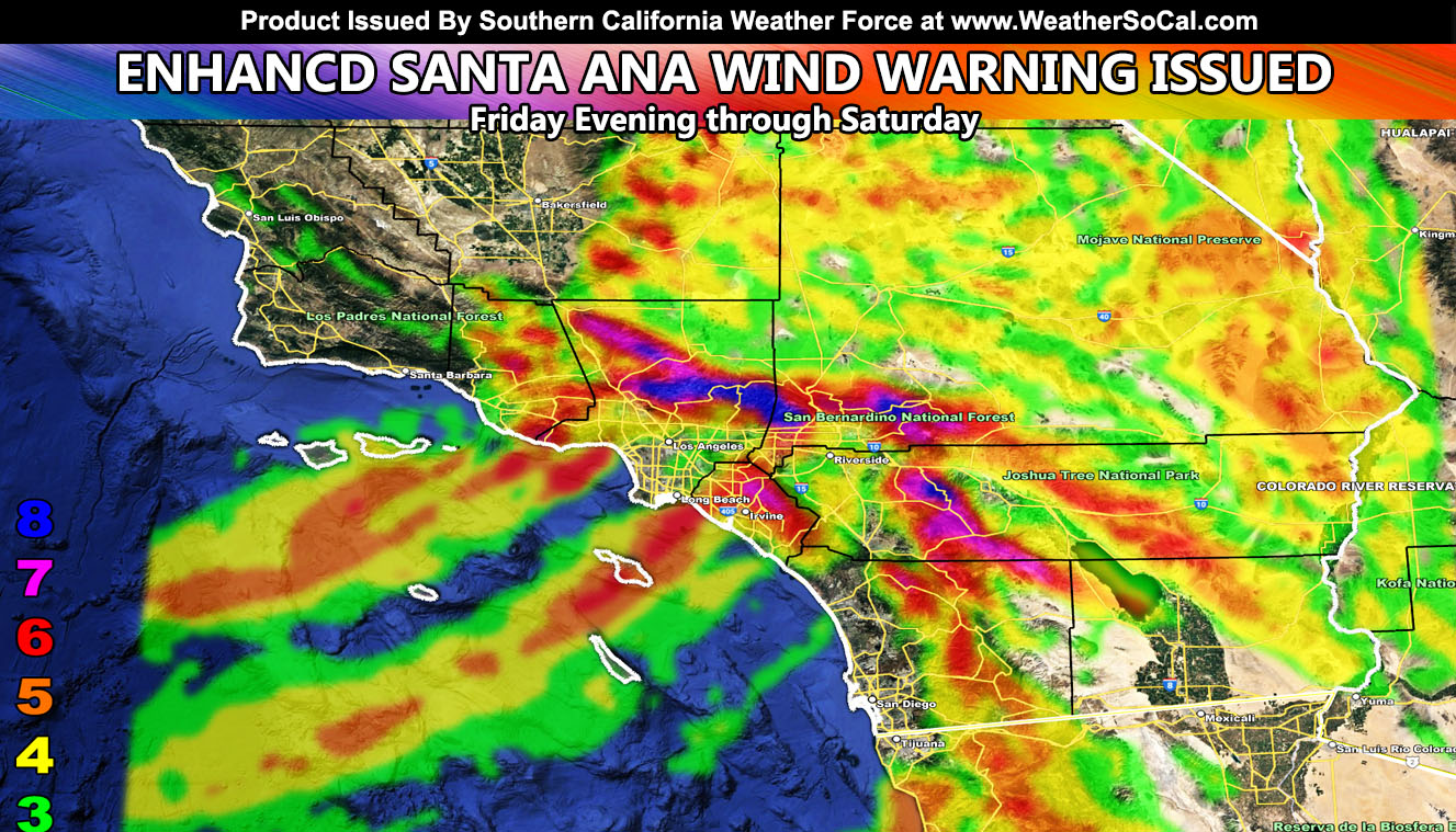
Southern California Weather Force has issued an Enhanced Santa Ana Wind Warning for a large portion of Southern California’s metro areas starting Friday and going into Saturday. The strongest wind event of the season will hit and you need to know the details on where the worst will be and what is recommended not to do for your own safety so read on for details …
A storm system moving into Arizona will generate strong northerly winds on the western periphery. This is a classic upper, thermal, and gradient support Santa Ana Wind Event, so much so these are where the most dangerous patterns come from if you are not familiar with the area. SCWF Santa Ana Wind Model showed a strong event days ago, having issued the official Santa Ana Wind Watch well ahead of time, it is now time to finalize this forecast.
Below passes and canyons today we do have a minor Santa Ana Wind pattern. This is only a taste of what is to come in all areas feeling it today. This will be short-lived today, ending this evening .. .but as Friday afternoon hits we will start to feel the effects from the upper-level low dropping into Arizona and by Friday evening all will break lose in the Santa Ana Wind prone zones, going through the overnight and into Saturday.
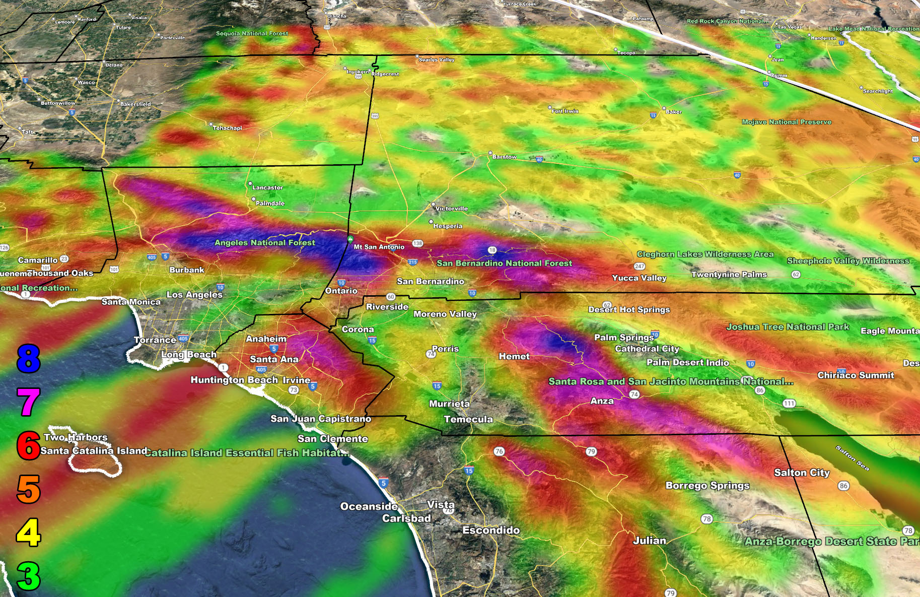
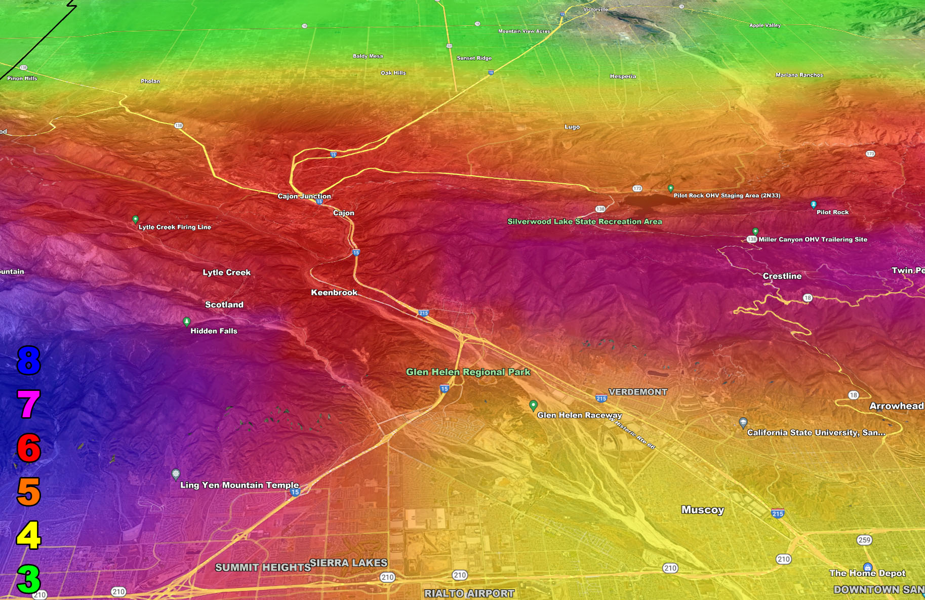
SCWF wind models do show damaging wind gusts in the metros areas. Even wind tunnels reaching as far as Compton so this means the San Gabriel Valley will have the winds as well when normally you do not. Upper support gives what is called a mountain rotor (wave). Mountain waves are like horizontal tornadoes just to the south of the mountains with a north wind like this. This slams air downward, a reason the areas near the Southern Los Angeles and San Bernardino Mountains will see the strongest winds. The strongest metro winds will be Chaffey College, in Ranch Cucamonga, where level 8 out of 8 is being detected on the SCWF wind model during this event.
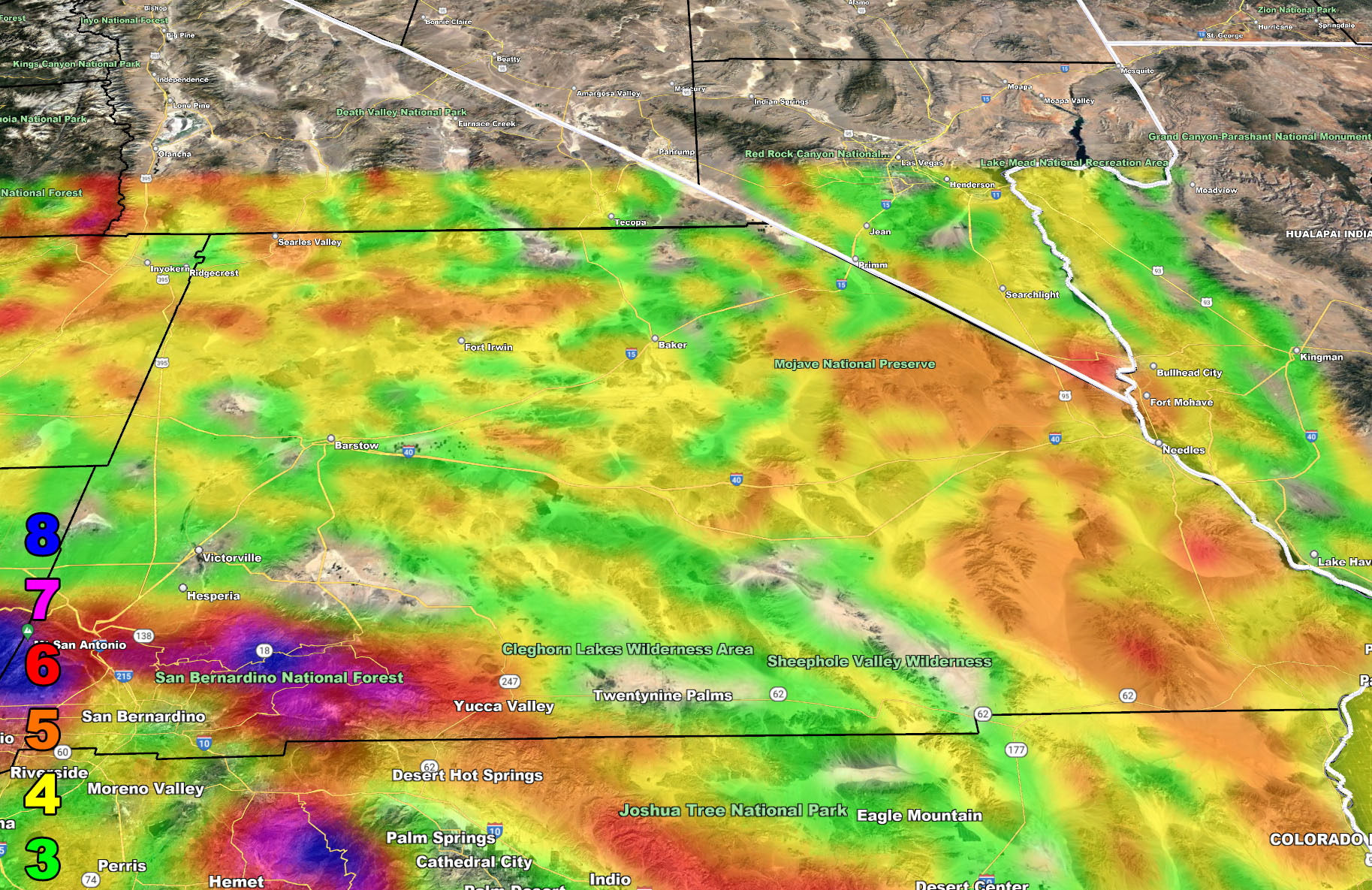
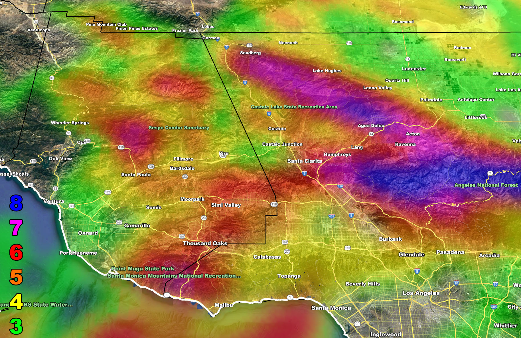
The Cajon Pass will have wind gusts strong enough to tip high profile vehicles up. If you feel you need to travel up there in a high profile vehicle take the 215 because I-15 from I-10 to the bottom of the pass will tip you over, no escaping that one. But, if you take the 215 from the 60 you will escape the strongest winds until the bottom of the Cajon Pass where the game will be over. This wind event is what I call a complete no way out zone. I-5 through the Santa Clarita Valley will be too dangerous to travel in a high profile vehicle, same with the Cajon and even Banning Pass. All freeways leading out of the Los Angeles Metro zones will have winds strong enough to tip you over. High profile is for truckers and/or campers. If you want to beat the winds, beat them before 3pm on Friday or you are stuck and I would not recommend going up the passes then.
The airport that will be DIRECTLY affected will be the Ontario International Airport. I do not expect LAX ground to be affected, but low-level winds around the airport may make for a bumpy ride into it. If you are traveling to Ontario International Airport Friday evening into Saturday you need to be very aware that the airport lies at the center of the wind tunnel this time. The arrival traffic pattern usually reverses out of the west, but as per the SCWF wind model, the west arrival pattern is also blocked with extremely strong winds so only the most experienced pilots will be able to land the planes then. You very well may be diverted to Las Vegas or Phoenix until the event passes. Planes usually do not divert to Los Angeles due to traffic and airline space, so Phoenix or Las Vegas is where your plane would divert.
Mariners need to be extremely cautious when going to and from Catalina Island and the Channel Islands through offshore Malibu. I know many instances where someone takes off in a sailboat from Ventura where the wind is a bit calmer and then capsizes when traveling southeast from there offshore Point Mugu or Malibu. The SCWF wind model clearly shows this is not a good idea and I would recommend not going out Friday evening through Saturday. Sunday is fine, Saturday is not.
If in the stronger level 6 conditions, do not park your car near trees. People have died when Santa Ana Winds have brought trees down on them in their own cars.
These winds are not for everyone, namely the San Diego Metro areas, where north winds do not affect you, but does affect your foothill/mountain zones …
Long Range: Something is throwing a wrench into the long range system. Whether it was the volcano’s gravity waves that were seen across the planet or something else, I stated before I could not issue a long range advisory due to uncertainty and distrust in the numbers I was seeing. I will continue to monitor it, but I know many are wondering about the first week of February surrounding your NASCAR fun. Holding off on storm patterns this long means it should start to crack soon so continue to monitor the forecasts here at Southern California Weather Force
Join the Facebook Page for Further Updates
SOUTHERN CALIFORNIA WEATHER FORCE MAIN:
The following articles pertained to the forewarning of this event;
January 17, 2022 – First Warning
Santa Ana Wind Watch Issued Ahead of Event Set To Impact Friday night into Saturday For Southern California
I control 10 counties in Southern California so there is a lot to say for various areas. The best I can do is let the images below speak for themselves.
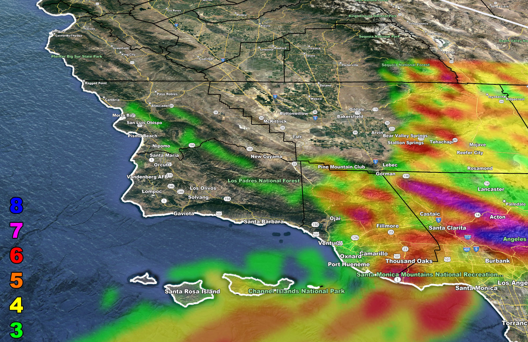
The maps below are of flood, rain, snow, snow-level, or wind intensity, whichever is available now. Each one is clickable. Map 1 is NW SoCal, Map 2 is SW SoCal, Map 3 is SE SoCal, Map 4 is NE SoCal, Map 5 is the Cajon Pass, and Map 6 is the SCV region, which includes Gorman at the top.
GET TO KNOW YOUR MAP BECAUSE THESE NEVER CHANGE LOCATIONS
Santa Ana Wind Forecast – Valid Friday evening into Saturday, January 21-22, 2022 –
MEMBERS (Click Here To Open The GPS Version Of These Maps In The Member Section)
Martin Wind Gust Intensity Scale –
8. Extensive widespread damage.
7. Trees are broken or uprooted, building damage is considerable. – High Profile Vehicle Roll-Over CERTAIN.
6. SOME Trees are broken or uprooted, building damage is possible. – High Profile Vehicle Roll-Over Likely, Do NOT recommend Traveling in this zone. If you are in this zone and above, do not park your car near trees as downed trees can easily harm you.
5. Slight damage occurs to buildings, shingles are blown off of roofs. HIGH WIND WARNING CRITERIA – High Profile Vehicle Roll-Over Possible if weight is not corrected.
4. Twigs and small branches are broken from trees, walking is difficult.
3. Large trees sway, becoming difficult to walk. POWER SHUTDOWN THRESHOLD DURING FIRE WEATHER / WIND ADVISORY CRITERIA

How to get these alerts with a premium subscription via e-mail by micro-climate zone AND/OR Get the GPS models for all events on your device enabled? (100 percent delivery time)
Click Here To Join The Season Tier
Join The Main Southern California Weather Force Facebook Group (50 percent delivery time) – You can join the main SCWF page as well through that group.
Click Here To Join The Page Today
FACEBOOK PAGES TO JOIN!
SOUTHERN CALIFORNIA WEATHER FORCE MAIN: Southern California Weather Force Office Main Page
SOUTHERN CALIFORNIA WEATHER FORCE METEOROLOGIST: – Just my public figure page that isn’t as large so maybe you can reach me better at times.
INSTAGRAM, TWITTER, TO JOIN!
Instagram – https://www.instagram.com/socalweatherforce/
Twitter – https://twitter.com/SCweatherforce
Southern California Weather Force is a custom weather alert service that began in September 1999 off and is regarded as the most accurate weather service in the region, offering custom alerts, maps, and models to help save life and property. The work done here is never 100% accurate, but it comes pretty close. Southern California Weather Force runs on zones, so if an event happens in a zone that is 10 miles from the border of your zone, the forecast is still valid to activate your zone’s alert system. A company quote to the public is that of “The Joker” and tells other agencies in weather this all the time… “This world deserves a better class of meteorologist… and I’m gonna give it to them”… out-forecasting even the National Weather Service with lead-time and precision, which makes this service a focus of ridicule and envy in the weather community due to having such accuracy. Alerts issued here are issued custom from this office and this office alone. You may not even hear it elsewhere, but if one is issued near or in your area, listen up because “if you do not wish to die in weather, follow, it’ll save your life one day.”