

Southern California Weather Force has issued a Santa Ana Wind Watch effective now for Friday night into Saturday for below passes and canyons, parts of the High Desert, all Mountain areas, and the Lower Desert areas along and near the Colorado River Valley and the long range wind models have been updated so read on for details …
NOTE: This article has SCWF model images of what is being talked about. Scroll below after reading and view those clickable images.
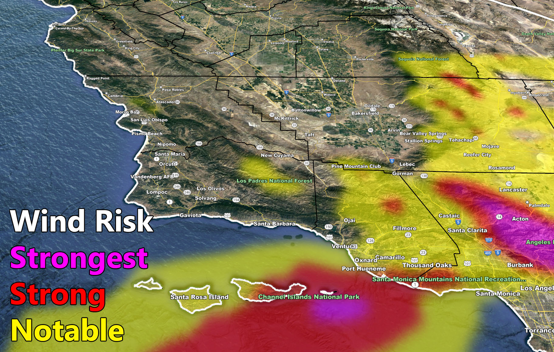
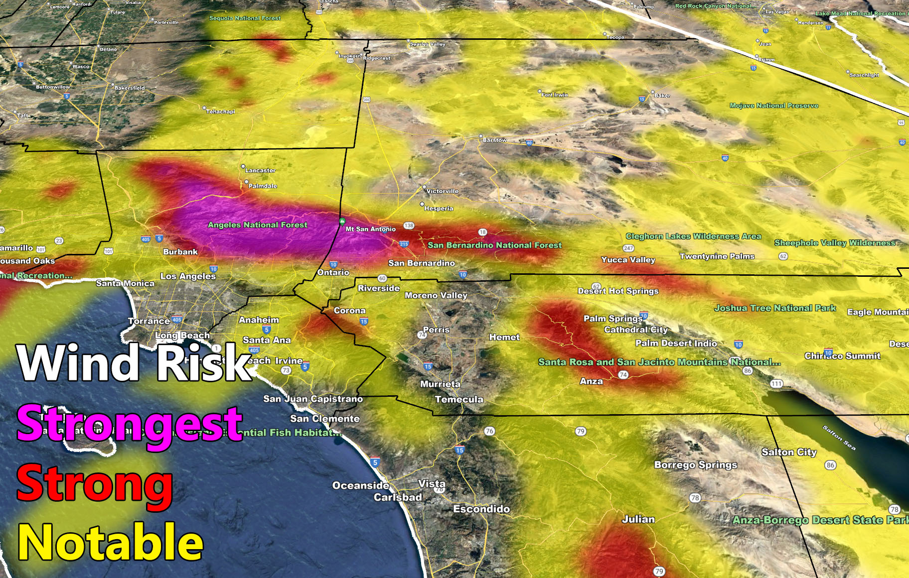
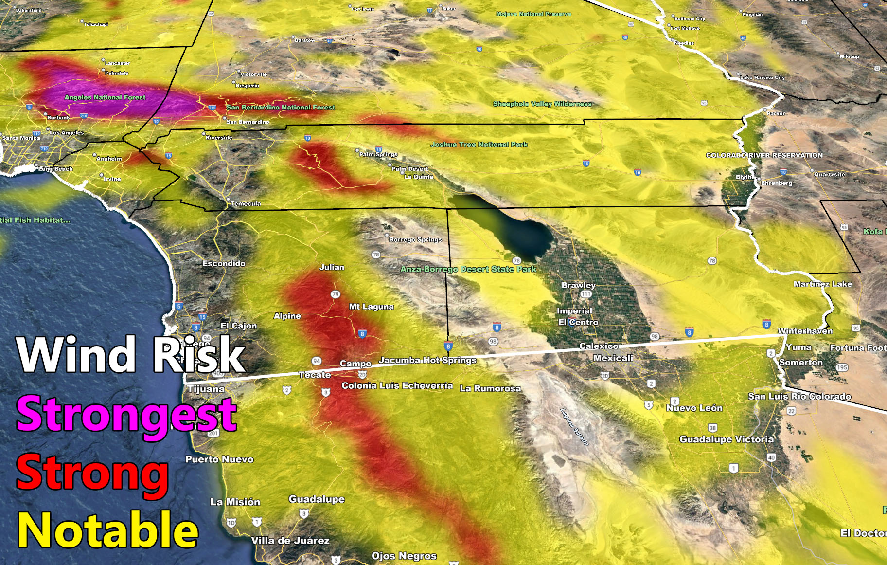
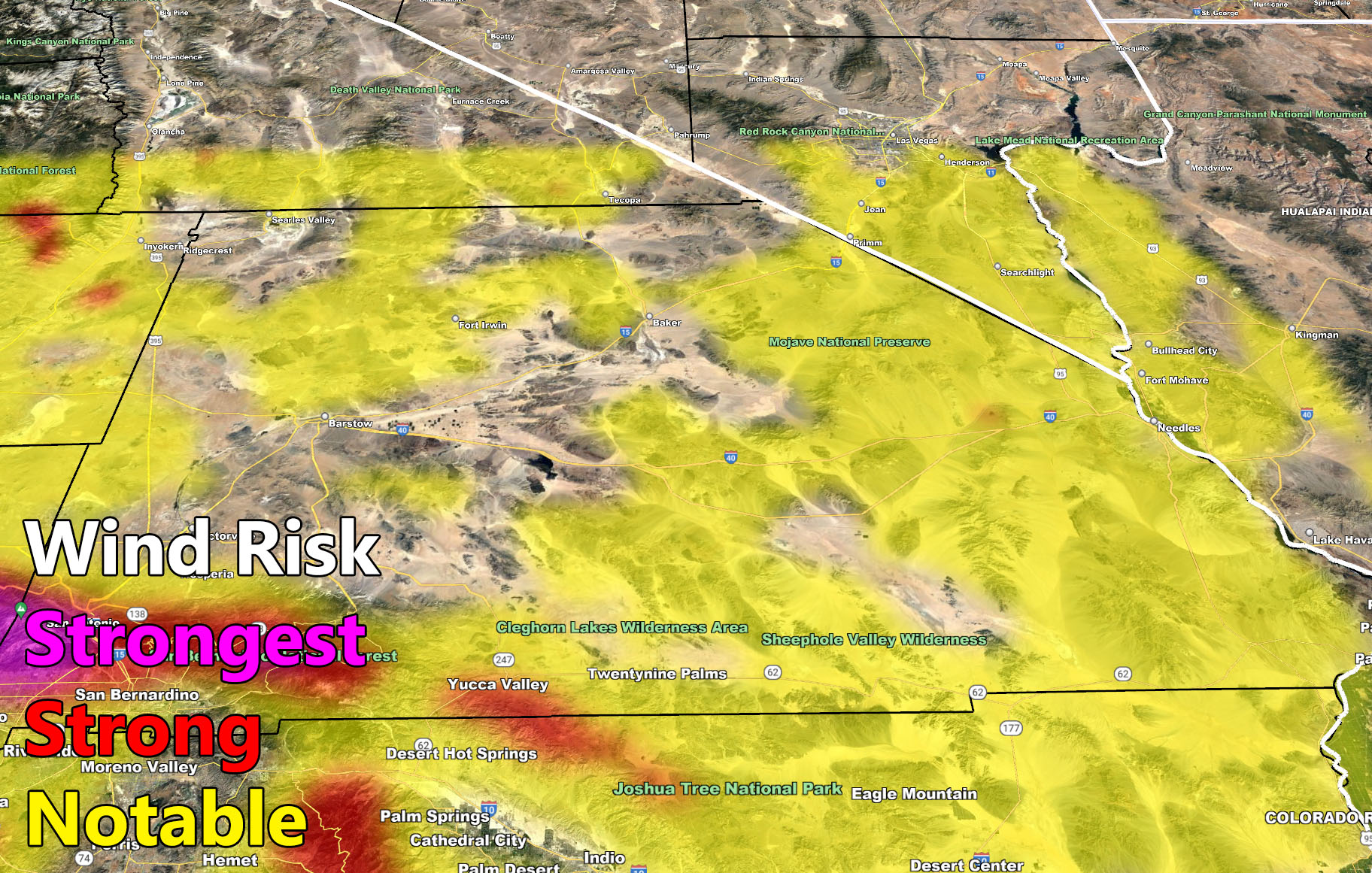
An upper-level low pressure system will drop into the Southwestern United States on Friday. This system will move directly over the state of Arizona, which puts us in Southern California under the upper/mid/low level west periphery where winds will move from northeast to southwest across the area, otherwise known as offshore flow. The cold upper-level low will bring all that air down and cause what looks to be a stronger Santa Ana Wind Event, at least the strongest we’ve seen thus far this month.
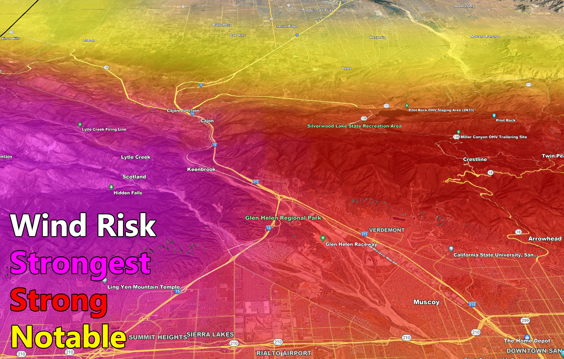
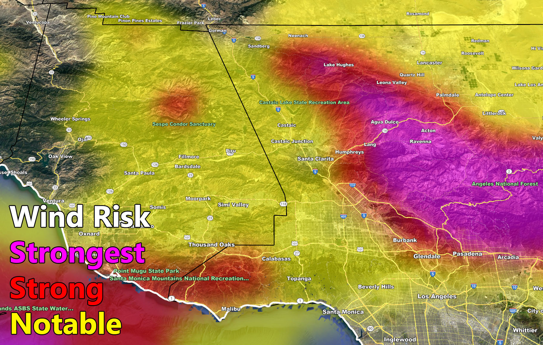
SCWF wind models have been updated in the long range showing the notable, strong, and strongest areas expected. As always, the strongest zones will be the Los Angeles County Mountains around Camp 9 west through Acton, along Highway 14. The upper support could even allow this event to open up the San Gabriel Valley in gusty wind potential with mountain wave activity diving down. Judging by the images below in the SCWF long range Santa Ana Wind Model, the winds showing on there going offshore from Ventura, blasting well offshore toward the Channel Island as well as the Orange County to Catalina wind tunnel showing up this far out signals this is shaping to be a strong event.
Given the cold air advection from the Great Basin in Nevada, these winds will be on the colder side.
Whatever precautions you take for impending Santa Ana Winds, do so now throughout the week as you have plenty of notice from here at Southern California Weather Force. Updates will be made according to any changes, but this article will do for now.
Join the Facebook Page for Further Updates
SOUTHERN CALIFORNIA WEATHER FORCE MAIN:
LONG RANGE: We start to see the Pacific become a bit more active after say January 24-25. This is when our best shot of actual storm activity to help bring January’s rainfall totals up some. It’s the best shot we have this month. I am not confident in strength at this time to issue a ‘long range weather advisory’ like I did last month. It just doesn’t have the kick I am looking for yet, but I am always monitoring. I do not expect it to be a major event and January is still scheduled to end well below average in precipitation.
I control 10 counties in Southern California so there is a lot to say for various areas. The best I can do is let the images below speak for themselves.
The maps below are of flood, rain, snow, snow-level, or wind intensity, whichever is available now. Each one is clickable. Map 1 is NW SoCal, Map 2 is SW SoCal, Map 3 is SE SoCal, Map 4 is NE SoCal, Map 5 is the Cajon Pass, and Map 6 is the SCV region, which includes Gorman at the top.
GET TO KNOW YOUR MAP BECAUSE THESE NEVER CHANGE LOCATIONS
Long Range Wind Risk Forecast – Valid Friday night into Saturday, January 21-22, 2022 –
MEMBERS (Click Here To Open The GPS Version Of These Maps In The Member Section)
How to get these alerts with a premium subscription via e-mail by micro-climate zone AND/OR Get the GPS models for all events on your device enabled? (100 percent delivery time)
Click Here To Join The Season Tier
Join The Main Southern California Weather Force Facebook Group (50 percent delivery time) – You can join the main SCWF page as well through that group.
Click Here To Join The Page Today
FACEBOOK PAGES TO JOIN!
SOUTHERN CALIFORNIA WEATHER FORCE MAIN: Southern California Weather Force Office Main Page
SOUTHERN CALIFORNIA WEATHER FORCE METEOROLOGIST: – Just my public figure page that isn’t as large so maybe you can reach me better at times.
INSTAGRAM, TWITTER, TO JOIN!
Instagram – https://www.instagram.com/socalweatherforce/
Twitter – https://twitter.com/SCweatherforce
Southern California Weather Force is a custom weather alert service that began in September 1999 off and is regarded as the most accurate weather service in the region, offering custom alerts, maps, and models to help save life and property. The work done here is never 100% accurate, but it comes pretty close. Southern California Weather Force runs on zones, so if an event happens in a zone that is 10 miles from the border of your zone, the forecast is still valid to activate your zone’s alert system. A company quote to the public is that of “The Joker” and tells other agencies in weather this all the time… “This world deserves a better class of meteorologist… and I’m gonna give it to them”… out-forecasting even the National Weather Service with lead-time and precision, which makes this service a focus of ridicule and envy in the weather community due to having such accuracy. Alerts issued here are issued custom from this office and this office alone. You may not even hear it elsewhere, but if one is issued near or in your area, listen up because “if you do not wish to die in weather, follow, it’ll save your life one day.”