
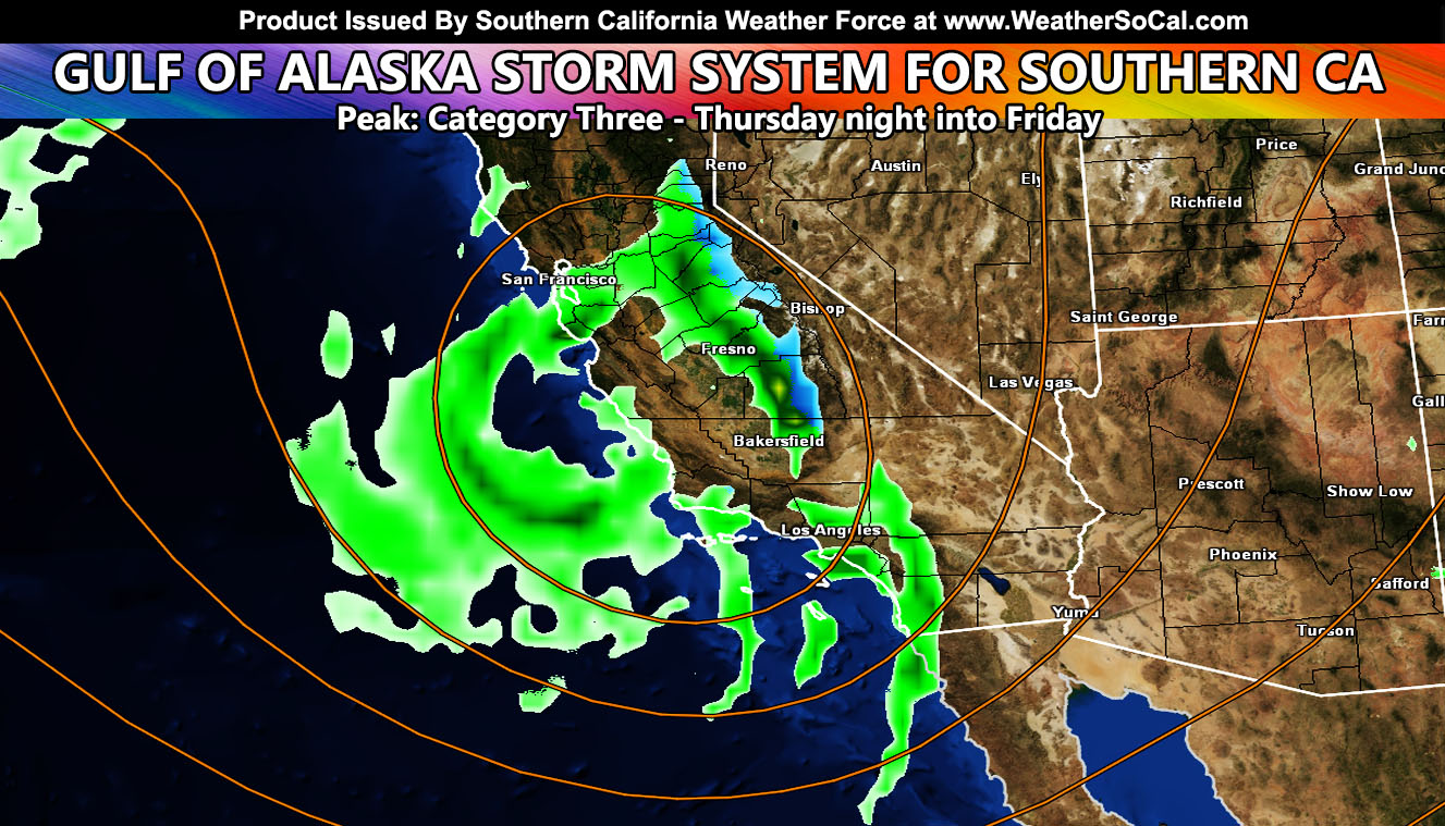
The first in the series of cold systems moving into California will hit Thursday night into Friday, delivering mountain snow, metro/coast rain and thunderstorms, gusty desert winds, and cold air so read on for details …
First I will be saying this. As of now, after 23 years, Southern California Weather Force will no longer be naming storms systems, but the category system will remain. I will continue to categorize systems between category one and six based on the expected dynamics. This will still give one an idea if the system is weak, moderate, or strong. This coming system has variable dynamics that will be listed now.
The system is expected to hit on Thursday evening for Vandenberg to San Luis Obispo, spreading overnight through Friday morning for the rest of the forecast area east of there, including Ventura, Los Angeles, Orange, San Diego, the Inland Empire, all mountain/desert areas. Here is what I see with it. The system is lacking low-level jet dynamics. This would ultimately keep coast/valley wind gusts below advisory strength, so I do not expect any damaging winds along the main front. Because of the lack of damaging frontal zone winds, the category will lower. Because of the thunderstorm risk zones and heavy rain at times, I will assign this a category three out of six, which is not a weak system, not a strong system, but a moderate system. A lot of times, cold core systems that are assigned category three do produce thunderstorms.
The system is what I call a west inside slider where it would act as a hybrid pacific storm / inside slider combined. These can get interesting because they dip far enough south to introduce cold air aloft. Cold air aloft with the March Sun angle does produce the better risk of thunderstorms, even if the Sun is not out. The closer to the upper-level low one is, the better chance of thunderstorms.
I will say right now that the lift/instability and trough axis of the system does favor Orange, Los Angeles, Ventura, Santa Barbara, SD, and San Luis Obispo County from Thursday night through Friday for thunderstorm risks, especially aiming Los Angeles proper. On Friday, the upper-level low would be directly over Gorman Pass, which puts from Santa Clarita/Gorman through Lancaster/Palmdale/Edwards/Mojave in a convergence boundary in the mid-levels that can easily be the pattern to produce a separate line of thunderstorms. Elsewhere, pop-up showers/thunderstorms due to the higher Sun angle and instability will be in the cards.
The snow-level with this system will be around 5,000 FT with non-sticking below that. I will not issue advisories separately right now, but consider this entire write-up having a Winter Storm Watch for the Eastern San Bernardino Mountains, especially in the ‘catcher mitt’ of Slide Peak, where the Snow Valley Ski Resort is for heavy snowfall/accumulation due to the southwest to northeast flow within the system.
So there you go for now … this will serve as a base first outlook for the system and I will be working watches/advisories in as the days move closer.
NOTE: Just because this system hits and ups the Los Angeles rainfall total for the season some does not mean it will continue this month for much longer. None of the systems behind this is strong, a weaker inside slider over the weekend with less precipitation, but colder air … The March 2022 forecast is valid to warm up for the second half of the month. Those links are below …
EMAIL ALERT SYSTEM … Spring 2022’s tier is open for the member section. There are still spots left to join the network tier. Within there, you get GPS models for rain, wind, snow or whatever is available along with many micro-climates to choose from to receive alerts not put on the main social media pages. You can EASILY miss these updates unless you get the service.
CURRENT MEMBERS: If you already renewed your service, you have been placed in the tier you have bought or upgraded to. If you have not and still received this, this will be the last e-mail alert you receive as accounts will be purged tomorrow as the Winter tier gets deleted off the network.
Here is the link for PayPal – https://www.southerncaliforniaweatherforce.com/scwf-discount-member-sign-up-page/
Here is the link for Venmo (bottom page) – https://www.southerncaliforniaweatherforce.com/southern-california-weather-force-fundraiser-for-2021-2022-season/
Service for Spring is $20 from March 1st through May 31st. If you wish to continue this service, please follow the link. You can do a full $20 for the season or you can go monthly.
The following articles pertained to the analysis and prediction of this forecast …
February 24, 2022
Warm Up Expected Across The Southern California Metros This Next Week Followed By A Return Of The Arctic Air Masses In March
FACEBOOK PAGES TO JOIN!
SOUTHERN CALIFORNIA WEATHER FORCE MAIN: Southern California Weather Force Office Main Page
SOUTHERN CALIFORNIA WEATHER FORCE METEOROLOGIST: – Just my public figure page that isn’t as large so maybe you can reach me better at times.
INSTAGRAM, TWITTER, TO JOIN!
Instagram – https://www.instagram.com/socalweatherforce/
Twitter – https://twitter.com/SCweatherforce
Southern California Weather Force is a custom weather alert service that began in September 1999 off and is regarded as the most accurate weather service in the region, offering custom alerts, maps, and models to help save life and property. The work done here is never 100% accurate, but it comes pretty close. Southern California Weather Force runs on zones, so if an event happens in a zone that is 10 miles from the border of your zone, the forecast is still valid to activate your zone’s alert system. A company quote to the public is that of “The Joker” and tells other agencies in weather this all the time… “This world deserves a better class of meteorologist… and I’m gonna give it to them”… out-forecasting even the National Weather Service with lead-time and precision, which makes this service a focus of ridicule and envy in the weather community due to having such accuracy. Alerts issued here are issued custom from this office and this office alone. You may not even hear it elsewhere, but if one is issued near or in your area, listen up because “if you do not wish to die in weather, follow, it’ll save your life one day.”