
Southern California Weather Force models are continuing to show the upper-level low moving into the Raiden Storm Diamond. As result, the northern periphery of the system is bringing scattered showers across Kern and San Luis Obispo County this morning.
Given the track of the low, it will go through the center of the Raiden Storm Diamond this afternoon and evening. This is the position at which to the northeast of it will have the strongest upper divergence (lift).
A Raiden Storm Diamond is a diamond-shaped zone southwest of Southern California. When the center of a low pressure system moves into it, one can expect shower and thunderstorm activity in the forecast area, widespread at that, the work of Master General Meteorologist Raiden Storm Publications.
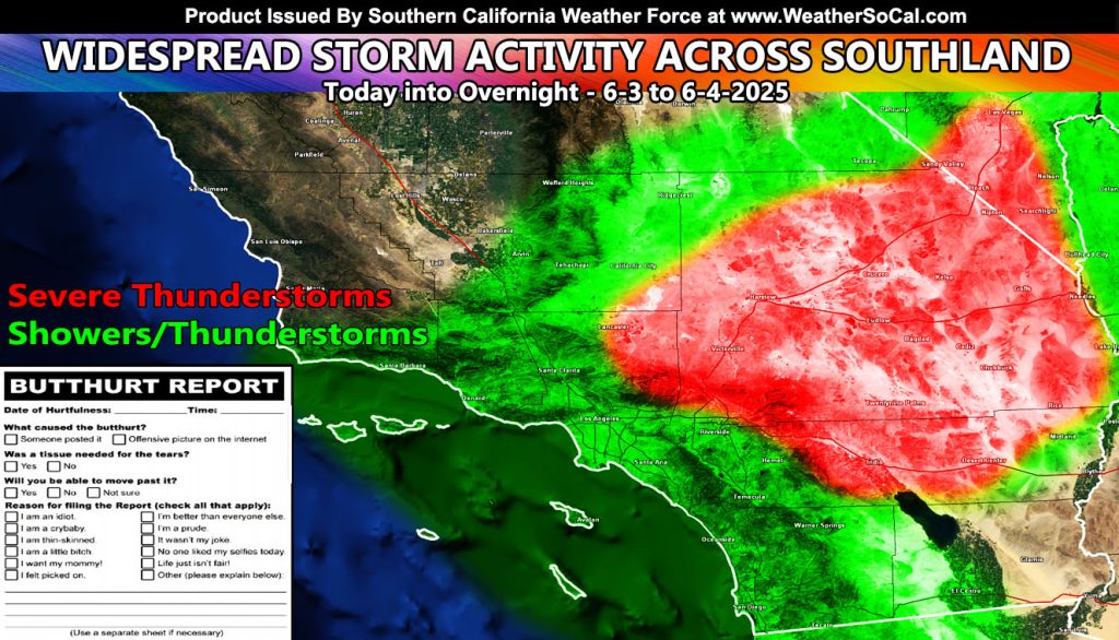
With the higher June sun angle, strong instability will be present, especially in the red-shaded zones. The entire High Desert, Southern Clark County, NV, Los Angeles to San Bernardino Mountain zones, the Morongo Basin, and even the Coachella Valley to Desert Center along I-10 will be affected with Severe Thunderstorms.
Storm motion wil start moving out of the mountain and desert zones later in the period, finally moving through the Los Angeles, Orange, Inland Empire zones, with San Diego County getting it later on. Instability is not as strong near the coastal zones, but I will still keep shower or thunderstorm activity all the way there.
Should a stronger cell form in the bight (Island Region of Southern California), waterspout potential will be there.
Given the outflow from the Morongo Basin into the Coachella Valley, a surge of this will ignite storms into the Western Imperial Valley zones as well.
The3 strongest cells today will produce damaging winds, large hail, flooding, and yes even a chance of isolated tornado chances due to the cold air aloft.
Raiden Storm
Master General Meteorologist