 Another tail-end charlie system will bring a round of quick hitting snow for the Kern Mountains/Gorman Pass, scattered showers in the Inland Metro areas, and another round of strong Santa Ana Winds that will fuel the Thomas Fire. Read on for details.
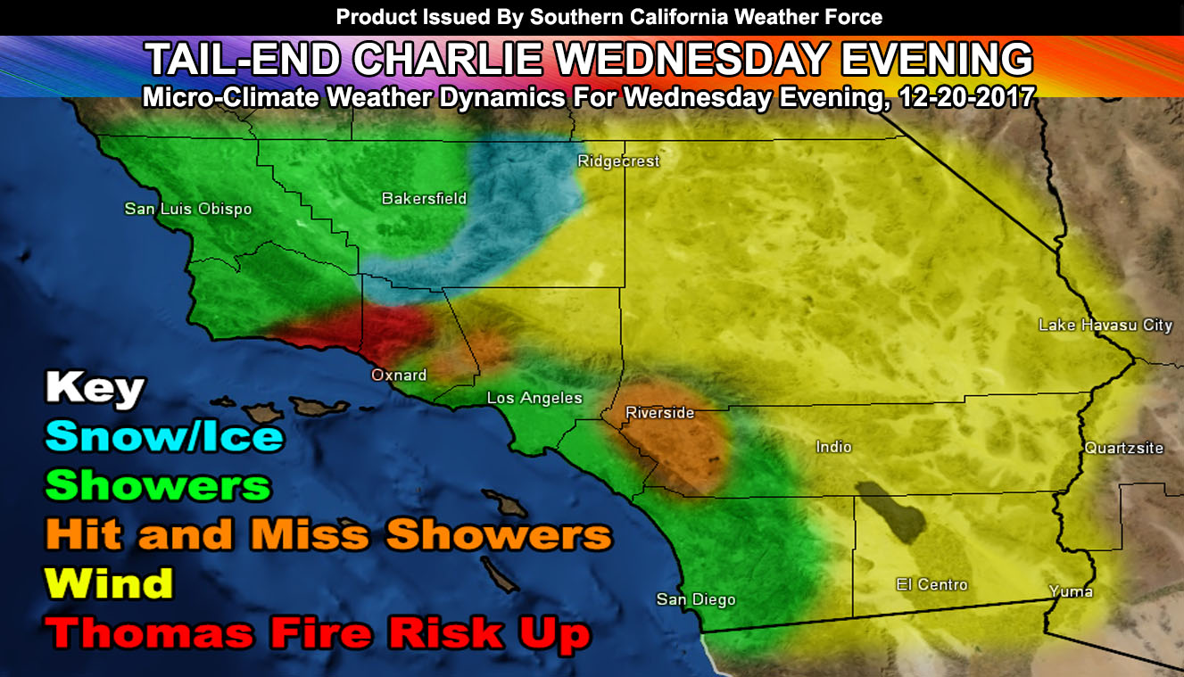
A lot to talk about with very micro-climate being impacted with weather on your Wednesday and Thursday. First we’ll follow the cold-front through Kern County as it moves over San Luis Obispo and Santa Barbara County on Wednesday morning for some light rainfall there. Yesterday I issued a Winter Weather Watch that will turn into an advisory this evening or tomorrow morning. This watch stated that a quick hitting around of snow will hit the Kern County Mountains, including the Gorman Pass on Wednesday afternoon/evening.
If it does not say “Liked” LIKE The Page Below and join thousands of informed weather forecast viewers in our region for more of the updates!
There are concerns now of ice potential, where the ground is freezing and just above it is warmer than freezing.. .so when the rain hits the pavement it instantly freezes. Concerns on the Gorman Pass and into the highways of the Kern Mountains are elevated due to this. Models here at Southern California Weather Force do show a glazing potential, which will be highly dangerous. Areas in the mountains that get precipitation on Wednesday evening will have black ice dangers overnight. Snowfall amounts will range from 1-3″, with the inch for the main mountain communities above 3,500 FT and the 3″ marks above 6,000 FT, namely Winters Ridge, in the Southern Tehachapi Mountains.
As the front moves through, the concentration will be the Thomas Fire area. On Wednesday evening, winds will gust out of the west at first with the passing front, with elevated humidity. This is a good thing … however in the flip of a switch later on in the evening… these winds will change and come out of due north, gusting between 35 and 55 mph in the fire zone, including Downtown Santa Barbara and into the Ojai zones. This will be very dangerous component as the humidity levels would then drop once again.
On Wednesday evening, the onshore flow and some lifting will provide for a chance of scattered showers in the LA/OC/SD and IE regions. This chance is the highest concentration in the Orange and Diego County areas, with a southwest flow against the mountains in your zones to the east … giving lifting to the area. Accumulations will remain light and some Inland Empire zones will be left out and dry while others get a shower moving through.
HATE THE ADS or Love the Forecasts and Want To Support The Work To Help it Stay? Become a premium member and support the service and receive forecast perks as well …
Click Here To Learn More …
As the front passes, cold air in the High Desert will cause a temperature gradient shift and thus the winds will be turning offshore into Santa Ana Wind Warning conditions overnight on Wednesday and into Thursday… the strongest winds will be after midnight on Wednesday until noon on Thursday, with residual wind gusts remaining through Thursday night in spots. Those of you flying in and out of Ontario Airport on Thursday, especially morning, must be prepared for delays and/or cancellations, with the chance you could also be diverted to another airport if you are landing.
The mountain and desert areas will have their nominal gusty 30-60 mph wind gusts from Wednesday evening through Thursday. Because this is an upper wind component as well, the entire desert areas from the High to the Low will see gusty winds, thus the wind advisory is for the entire Southern California Desert zones.
As for the temperatures, this is a cold air-mass settling in for Wednesday night so by sunrise on Thursday where the wind does not blow, in the metros you’ll see temperatures in the 30s, with many high desert areas in the 20s, which would be your Hard Freeze Warning from me. Many coastal zones will be between 40-50F. Freezing temperatures will also hit the Kern Valleys, west to the inner San Luis Obispo County zones.
The member section will have updates in all sectors from snow, rain,and wind, updated often through this small event.
Stay tuned to Southern California Weather Force for any additional updates
Click Here To Find Your Zone On Facebook For Updates Now and In The Future
Click Here To Find Me On TWITTER.