
We had a close call with naming a storm not long ago during the heart of the storm season called DICK, the next name on the 2018-2019 storm name list here at Southern California Weather Force, however, it came short and it couldn’t acquire the name. Will this be the time of DICK? Read on for details as the system moves into the SCWF forecast jurisdiction on Thursday, maximizing Friday into the Weekend.
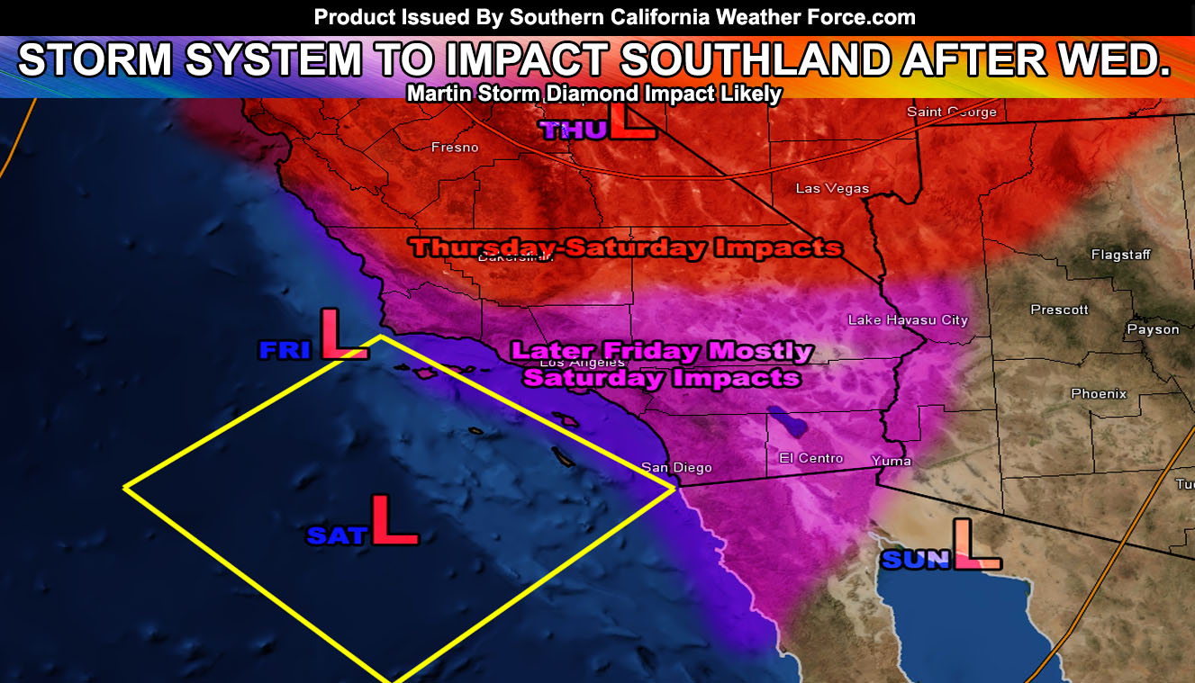
As stated in ‘This Week In Weather Episode 1’, which aired on the Southern California Weather Force Facebook Page, a strong system would move out of the north after Wednesday and last into the weekend. Confidence is rising that this system bodes the characters to make it into the Martin Storm Diamond. The Martin Storm Diamond is a diamond-shaped zone southwest of the Southern California coast in-which if the center of a low-pressure system moves into it, the lifting zone would be placed in the metro zones, depending on where the center crosses within it.
This system looks like it’ll cross the northwest and west/south-central side of it. It does give some good lifting through the High Desert and the Kern County zones with this passage and Thursday would see the start of it as the lifting associated with the system will be in the High Desert with Barstow the southern end of the latitude expected, with an east to west line from Las Vegas through Barstow northward and into the Kern County zones, east to San Luis Obispo County. This is the zone to monitor on Thursday.
On Friday the system will start to enter the northwest section of the Martin Storm Diamond, which would bring Vandenberg AFB into the mix and keep storms ongoing in the same areas as Thursday. Sometime later Friday and especially Saturday is when the system locks the southwest-central zone of the diamond and as a result, the entire Southern California area will have lifting and it will be anyone’s game from coast, valley, mountain, and desert no matter where you are to get precipitation in the form of either rain or hail, including the risk of thunderstorms. The system departs after Sunday, but residual moisture would keep mountain zones under the watch for storms.
As always, stay tuned to official updates here at Southern California Weather Force
For The Main Weather Facebook Page Click Here and Join.
End Article
OPTIONAL: Southern California Weather Force main page now has models, agendas, the alert map, and other things updated during storm events. You can bookmark the main site and check back during an event for the latest updates.
Click here to view the main page
EMAIL ALERTS AND ASK THE WEATHER OFFICE A QUESTION: It pays for itself in one storm system. A very affordable e-mail alert system that only gives you SCWF weather alerts in YOUR micro-climate area. Also, you can ask the weather office a question at any time if you get that add-on.
Click here to join
MICRO-CLIMATE ALERT FACEBOOK GROUPS: Find yours today!
Click here to join
FACEBOOK PAGES TO JOIN!
SOUTHERN CALIFORNIA WEATHER FORCE MAIN: if it does not say “Liked” LIKE The Page Below and join thousands of informed weather forecast viewers in our region for more of the updates! noticeable
BEHIND THE SCENES FORECASTS/UPDATE PAGE: if it does not say “Liked” LIKE The Page Below and join thousands of informed weather forecast viewers in our region for more of the updates! noticeable
FOR THE CALIFORNIA FAULT STRESS MODEL PAGE: if it does not say “Liked” LIKE The Page Below and join the official page to the California Fault Stress Model