Pacific Storm Dick is Sagging Downward as we speak. The system has east-northeast to west-southwest flow in the mid-levels and this is the direction of storm travel today. I decided to go with my Monsoon Model for this event since the elevation zones will act to serve as the starting point of thunderstorms so for the break-down of today’s forecast, and for the Elsinore Convergence Zone of the Inland Empire, consider this a Severe Thunderstorm Watch. Hail and possible weak tornadoes will be possible. read on for details.
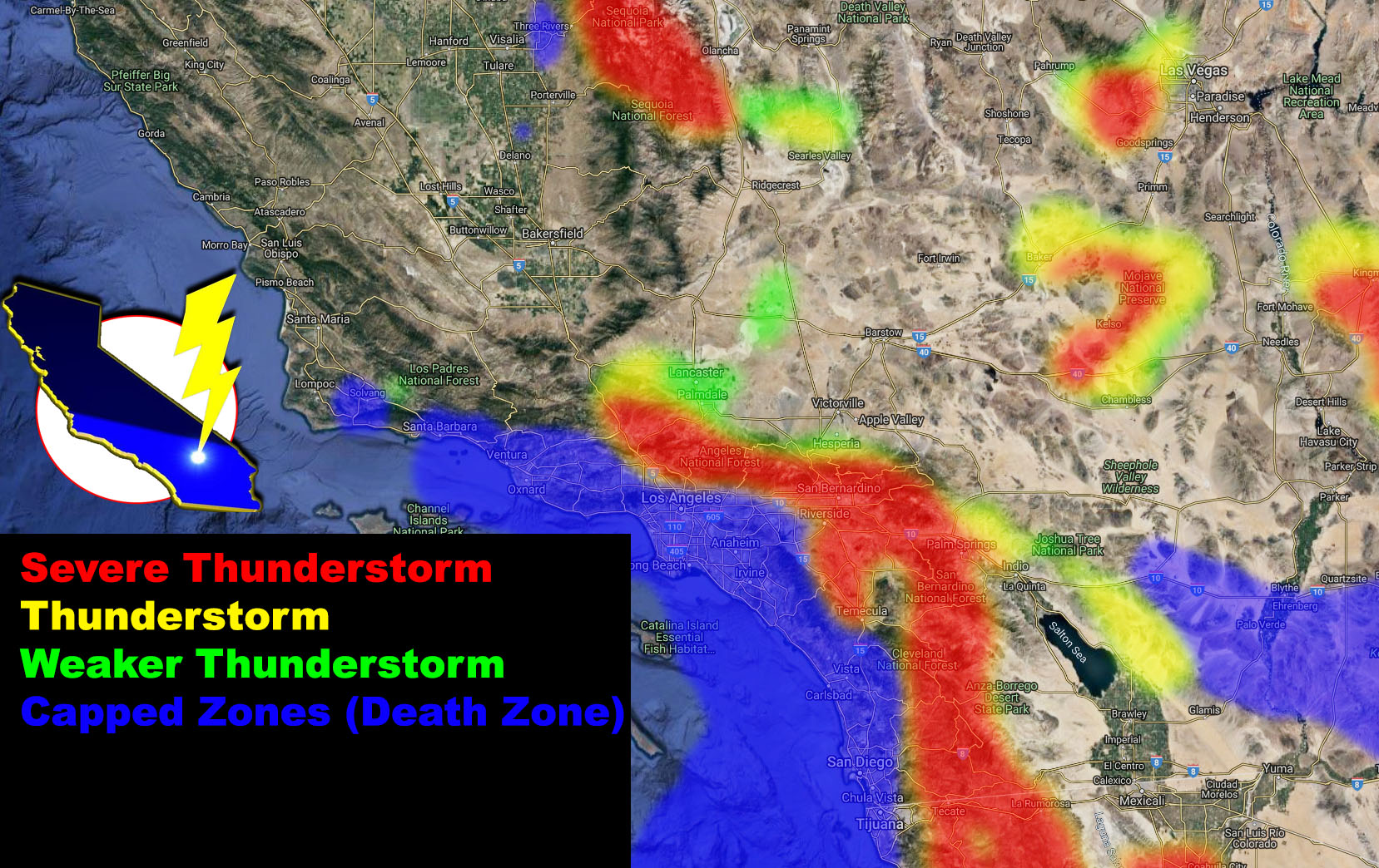
Much clearer skies today than it was yesterday and this is serving to bring steeper instability profiles across the region already at 11 am with over 500 j/kg already over the mountains. This will be the main focus today once the mid-level cap breaks. As this breaks, thunderstorms would get the chance to form over them, heading quickly thereafter to the west-southwest into areas neighboring them. The Monsoon Model does show ‘severe thunderstorm’ probabilities (in the red on the article image) in the mountains and off them and you can find if near or on you is shaded by looking at that model (image in the article). The most notable zone is the Elsinore Convergence Zone somewhere from say Hemet/Perris and yes, even you in Temecula. This zone would be primed for activity based on the instability, lift, and flow today.
The dark-blue shading saying ‘Death Zone’ means the storm death. This is an area of stable air, generated by the ocean. This air will serve as a shield to the storms coming out of the east so once they hit this layer… they will die. So I’m not looking at these making it to the metros of San Diego, Orange, Los Angeles, or Ventura County in a way that they will further in the reds/yellows inland. Could get some showers, sure … why not? But as far as thunderstorms are concerned, the stable layer is pretty reinforced in the metros. Best areas in the LA area would be the SFV/SCV and/or the Tujunga/Sunland zones.
Furthermore, it does show the Metro High Desert in a shading BEFORE the 2pm hour, which is what this model is from. 2pm to at least 5pm. So between 11am and 2pm we will see thunderstorms in the high desert.
As I stated before… Dick is hit and miss and some of you will not see much from it. On your Sunday, the flow is our of almost due north and weak, thus convection would be reserved to only the mountain zones, mainly some LA, but mostly the San Bernardino, Riverside, and San Diego Mountains …
As always, stay tuned to official updates here at Southern California Weather Force
OPTIONAL: Southern California Weather Force main page now has models, agendas, the alert map, and other things updated during storm events. You can bookmark the main site and check back during an event for the latest updates. Click here to view the main page
EMAIL ALERTS AND ASK THE WEATHER OFFICE A QUESTION: It pays for itself in one storm system. A very affordable e-mail alert system that only gives you SCWF weather alerts in YOUR micro-climate area. Also, you can ask the weather office a question at any time if you get that add-on. Click here to join
MICRO-CLIMATE ALERT FACEBOOK GROUPS: Find yours today! Click here to join
FACEBOOK PAGES TO JOIN!
SOUTHERN CALIFORNIA WEATHER FORCE MAIN: if it does not say “Liked” LIKE The Page Below and join thousands of informed weather forecast viewers in our region for more of the updates! noticeable
BEHIND THE SCENES FORECASTS/UPDATE PAGE: if it does not say “Liked” LIKE The Page Below and join thousands of informed weather forecast viewers in our region for more of the updates! noticeable