
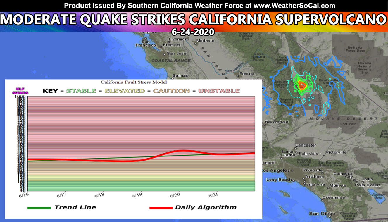
On June 19th to 20th the California Fault Stress Model had a brief spike which went brushed off and ignored. Because of the Nevada quake months ago, the ULF wave background noise has been off the charts and this one will continue to show that. This quake hit in the Long Valley Caldera, California’s Super Volcano that may are not aware of so read on for details.
Preliminary magnitude was set at a 6.1, but later revised by USGS down to a 5.8 magnitude quake, which makes it a moderate quake. It was felt as far as Southern California and the data is as followed;
| Magnitude | 5.8 – moment magnitude (Mw) | |
| Time | Wednesday, June 24, 2020 at 10:40:49 AM (PDT) Wednesday, June 24, 2020 at 17:40:49 (UTC) |
|
| Distance from | Lone Pine, CA – 17 km (11 miles) SSE (149 degrees) Olancha, CA – 19 km (12 miles) N (9 degrees) Independence, CA – 44 km (27 miles) SSE (152 degrees) Coso Junction, CA – 45 km (28 miles) N (357 degrees) Little Lake, CA – 58 km (36 miles) N (354 degrees) |
The quake hit to the north of the Ridgecrest quake almost exactly a year ago. It likely was a stress trigger event from that exact fault-zone, which looks rather connected. This hit in the Long Valley Caldera, California’s Super Volcano that can go up at any moment. It is said that the Long Valley Caldera might be worse than Yellowstone with an unknown time of eruption, but it bears to watch.
The large 17 x 32 km Long Valley caldera east of the central Sierra Nevada Range formed as a result of the voluminous Bishop Tuff eruption about 760,000 years ago. Resurgent doming in the central part of the caldera occurred shortly afterwards, followed by rhyolitic eruptions from the caldera moat and the eruption of rhyodacite from outer ring fracture vents, ending about 50,000 years ago. During early resurgent doming the caldera was filled with a large lake that left strandlines on the caldera walls and the resurgent dome island; the lake eventually drained through the Owens River Gorge. The caldera remains thermally active, with many hot springs and fumaroles, and has had significant deformation, seismicity, and other unrest in recent years. The late-Pleistocene to Holocene Inyo Craters cut the NW topographic rim of the caldera, and along with Mammoth Mountain on the SW topographic rim, are west of the structural caldera and are chemically and tectonically distinct from the Long Valley magmatic system.
What else does this year have in store for us …
For Southern California Weather Force Facebook – Click Here
For Arizona Weather Force – Click Here
For National Weather Force – Click Here
For California Fault Stress Model – Click Here