
As stated in the article on October 7th, A ridge of high pressure is expected to develop this next week and a cutoff low will form underneath that to our south. This cutoff system will be monitored on to what impacts it can have so read on for details …
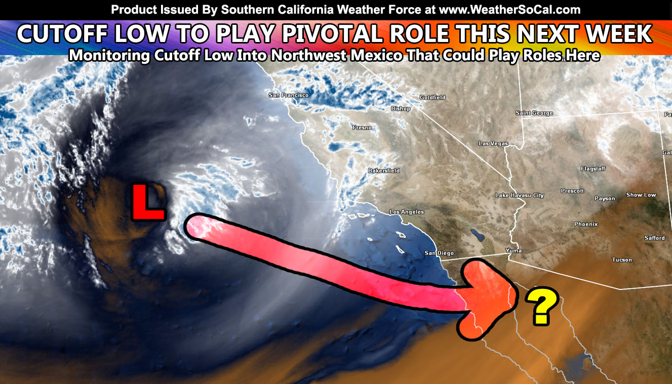
This cutoff low is very nicely defined on satellite. It is moving in our direction, however it is also gliding southward away from the jet stream. Basically the jet stream impacting Washington this weekend has dropped an upper level low like a jet dropping a bomb. This is sliding towards and south of our area over the weekend and it already is noted very well by the ‘cooler temperatures’ and marine layer south and west of the mountains we have been having. The marine layer will be in each day this weekend with coverage only near coastal cities on Monday with weak offshore flow developing as the cutoff system enters Northwest Mexico where the (?) is on the image in this article.
Before you read on, Facebook changed their algorithm and I put a video out explaining how you can see the posts from me at the top of your news-feed and that can be viewed by CLICKING HERE
The question mark is what the question is. Where to after that? Does the base of the trough re-attach and take it eastward, giving us no impacts? Or does it let it go and drift further south and meander all this next week. Meandering would mean a blocking pattern is starting to form, which is good because deeper troughs (storms) will not be far behind it. At the current time I will wait for more data and see what to do with it, but if it does drift south a bit and then north, it may gather some tropical moisture and then the Southwest United States would have some activity later this next week.
Now do I want a large cutoff right now? No… I do not.. even though we need rain. The reason I do not right now is because I am figuring to base my final forecast off the 1970-1971 storm season and we didn’t see much in October.. but we did towards November and December. The problem with that season pattern (La Nina as well) is after December we didn’t have too many storms so a rough start but a puny peak/end season. We had all the rain at once for the start of the season. This is what I’m eying right now and I’ll need to continue reviewing the final numbers for the final forecast to be released sometime around October 26th or so. I decided to give myself another week from the 20th and monitoring that week one more time before making the final decision.
So there you have it, the cutoff low will move through this weekend, south of us. We will have a heatwave next week with weak offshore flow… (no strong Santa Ana Winds) … increased fire danger likely as well … and a blocking pattern trying to develop by end October into November where the pattern should change from what it is now.
Did you know? I now have a page for a lot of science stories, including some funny/interesting/weird stuff as well? Stuff you would be interested in like Astronomy, Solar Flares, Volcanoes, Earthquakes, and more! CLICK HERE AND FOLLOW/LIKE/JOIN/INTERACT WITH NEWS REPORT BANDIT TODAY!
As always, stay tuned to Southern California Weather Force for official forecasts and updates in weather across Southern California
Join Southern California Weather Force main Facebook Page for future updates!
MICRO-CLIMATE ALERT FACEBOOK GROUPS: Find yours today!
Click here to join
Reading for another state? Join my national page – https://www.facebook.com/nwfweather/
FACEBOOK PAGES TO JOIN!
SOUTHERN CALIFORNIA WEATHER FORCE MAIN: Southern California Weather Force Office Main Page
NEWS REPORT BANDIT: Tired of Politics and Celebrities and want funny, interesting, weird stories, including science like solar storm, earthquake, volcano, space stories updated 1-2 times a day?
FOR THE CALIFORNIA FAULT STRESS MODEL PAGE: For SCWF official updates to the California Fault Stress Model and more!
PROJECT DESTINI WORLDWIDE QUAKE PREDICTION – A system that shows worldwide plate stress due to numerous factors
INSTAGRAM AND TWITTER ACCOUNTS TO JOIN!
Instagram – https://www.instagram.com/socalweatherforce/
Twitter – https://twitter.com/SCweatherforce