
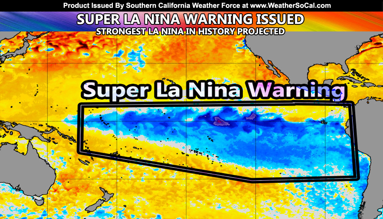
Southern California Weather Force has upgraded for the first time in office history from La Nina Warning to Super La Nina Warning. As projected in my May forecast, I stated that this year’s La Nina would be a strong one. Recent numbers of mine now indicate this to be true and over, with a projection value of the strongest La Nina to ever develop in the Equatorial Pacific Ocean in recorded history, coming just five years from the strongest El Nino values in history. The waters down there will be the coldest in anomaly we have ever recorded and this will put an interesting twist on our season forecast. Read on for details …
REMEMBER: Download the FB page notification app for this page here – Download page is here – http://www.nationalweatherforce.com/2020/07/07/fb-weather-phone-app/
In the first paragraph I do not put link in it because the introduction paragraph goes on the main Facebook Page. The link to the May article can be viewed by Clicking Here. The quote from five months ago stated, “First and foremost, the Equatorial Pacific Ocean is showing signs of La Nina right now with the latest sea surface temperatures coming in. Other agencies expect this to be a hiccup and that we will likely see a neutral season coming up, which is neither La Nina or El Nino. However, trends on my calculations are certainly showing up as much stronger of a La Nina signal and this will happen as early as this Summer as cold water up-welling occurs west of South America with a weakening of the trade winds.”
This is exactly what we are seeing right now. If you clicked that article link from May, the article image was the La Nina Watch. Look how it is from water temperatures compared to the article in-which you are reading right now. The amount of coverage and depth of the cold water is unprecedented. Now… what does this mean? The 1970-1971 season had a moderate to strong La Nina. It had a really good November and December rainfall combination here in Southern California. A stronger La Nina, even a Super La Nina, which has never been seen before will put a wrench in any analog forecast. We could see 8 inches, 12 inches, 14 inches, etc… The margin for a strong 1999-2000 season is around 12 inches of rain in Los Angeles, where I officially measure.
However, this is now projected to be a Super La Nina by numbers. During the 2015-2016 Super El Nino, the public expected much more rain than what was received. It acted more like a La Nina. So, Newton’s Law states, “For every action, there is an opposite and equal reaction”, in-which the case would be me now having to look into an El Nino analog such as 1991-1992, which did have over 20″ of rain in Los Angeles. The 1991 October is acting very similar to this one. It started off slow and gained steam. But, we have never seen a Super La Nina just like we never saw a Super El Nino. If it behaves like a La Nina should, the 2006-2007 season with only 3 inches of rain in Los Angeles would come back to haunt us. October 2006 is acting very similar to this month but it was colder than average, this month has been hotter.
So let’s break this down by analog.
1991-1992 season – Strong El Nino – October 1991 was hotter and drier with cutoffs east of here similar to what will happen soon.
1999-2000 season – Strong La Nina – October 1999 was hotter and drier with a ridge and no cutoffs east of here.
2006-2007 season – Weak El Nino – October 2006 was colder and drier.
The common thing happening with the October 1991 is hotter/drier here with cutoffs. It also was very cold in the Upper Midwest like Minnesota while 1999 was not as much. It also had ridging over the Southeastern United States that blocked a lot of the freezing temperatures, keeping it north of there. 1999 did not. So I’m dealing with a Super La Nina where October 2020 is acting like the Strong El Nino season of 1991. And in 2015 I dealt with a Super El Nino that turned out into a La Nina drier acting year.
So in conclusion, the thing to best do for me is see halfway into November and see where we stand. IF this is acting like a Strong El Nino, the flooding season will be between December and March, with a lot of rainfall all at once. Projections from every single source alive is going with a much below average season, talking under 7″ of rainfall … but a Super La Nina has never been seen before and must not be ignored to study.
Facebook changed their algorithm and I put a video out explaining how you can see the posts from me at the top of your news-feed and that can be viewed by CLICKING HERE
Did you know? I now have a page for a lot of science stories, including some funny/interesting/weird stuff as well? Stuff you would be interested in like Astronomy, Solar Flares, Volcanoes, Earthquakes, and more! CLICK HERE AND FOLLOW/LIKE/JOIN/INTERACT WITH NEWS REPORT BANDIT TODAY!
As always, stay tuned to Southern California Weather Force for official forecasts and updates in weather across Southern California
Join Southern California Weather Force main Facebook Page for future updates!
MICRO-CLIMATE ALERT FACEBOOK GROUPS: Find yours today!
Click here to join
Reading for another state? Join my national page – https://www.facebook.com/nwfweather/
FACEBOOK PAGES TO JOIN!
SOUTHERN CALIFORNIA WEATHER FORCE MAIN: Southern California Weather Force Office Main Page
NEWS REPORT BANDIT: Tired of Politics and Celebrities and want funny, interesting, weird stories, including science like solar storm, earthquake, volcano, space stories updated 1-2 times a day?
FOR THE CALIFORNIA FAULT STRESS MODEL PAGE: For SCWF official updates to the California Fault Stress Model and more!
PROJECT DESTINI WORLDWIDE QUAKE PREDICTION – A system that shows worldwide plate stress due to numerous factors
INSTAGRAM, TWITTER, and NOW TIKTOK SHORTS ACCOUNTS TO JOIN!
Instagram – https://www.instagram.com/socalweatherforce/
Twitter – https://twitter.com/SCweatherforce