
A weak system right on track to the previous forecast storm statements for members over the last couple of days will hit overnight tonight and into Monday. The system has a surface low south of here so some may be on the dry side for this. A much larger named system will hit on Tuesday and if trends continue, she’ll be named Diane. Read on for the details through tonight, tomorrow, and some details for Tuesday.
if you are a member then you will receive advanced micro-climate alert information on these events. Join today with a reduced partial season pass price and check out what is offered during events when warranted at our member section. Click Here To Learn How To Super-Charge Your Forecast Alerts
Weather alerts will be going out of the next 24 hours as trends are being monitored for Tuesday’s system. Right now for the LA/SBD Mountains I’m continuing to see a snow level of 7,000 FT. for Tuesday along the main swath of the front. This higher snow level is making me halt any higher class alerts, however at the snow level and above in all mountain ranges you will see Blizzard Warning criteria conditions, with wind gusts well over 35 mph and pounding snowfall. This would be above our winter storm warning alert, a blizzard warning would be the highest alert for winter storms issued by this service.
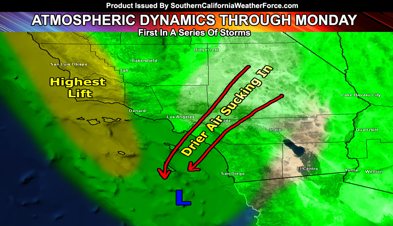
For now let’s concentrate a bit on tonight and Monday. A system will move through and it is starting to cutoff as the jet stream moves further south into Baja. This storm system is literally stretching itself apart just southwest of our forecast region and the ‘bit and pieces’ would hit us with various strengths. The member section precipitation chart Model 1E-HR shows a good idea for this system where the highest amount of precipitation from it in the forecast area would be west of Ventura … and south of the OC/IE areas down into the metros of San Diego east along I-8 from there.
NOTE: SCWF Membership holders, go to the member section for the precipitation link – as others will update accordingly. Click Here To Enter Member Section
The LA/OC/IE/High Desert zones would be under the influence of the surface low’s weak northerly winds … which would bring in drier air below 2,000 feet and bring much lighter precipitation values as a result. Because of this, if this is correct, all mountain regions through tonight/tomorrow would be hosting snow-levels at 6,500 to 7,000 FT with stronger warm air advection out of the southwest. This is the reason I’ve halted any alerts thus far … as only a dusting could be expected at levels just below that … and if dry air sucks through the Big Bear Lake zones during this time-frame, much less as a result … with the most west of Los Angeles in the upper elevations of the VT Mountains.
This system could produce the strongest lifting over the SBA/SLO County regions overnight tonight and into Monday. This slight increase in divergence could pop-up heavier showers and maybe even thunderstorms … this area would be the most convective out of the entire region for this first system.
The air will continue to be tropical as the next system moves toward us, with an impact due on Tuesday what will be named Pacific Storm Diane tomorrow will pack a punch with a major front containing the risk of strong wind gusts, thunderstorms,, and blizzard conditions above 6,500-7,000 FT. This system along the coast and a bit inland for the metros may be a CATEGORY FOUR out of our one through six scale and at the current time contains the dynamics for tornadoes to be possible at the coast and a bit inland. Trends are continuing to be monitored so stay tuned to Southern California Weather Force updates .. .and if you are a member then you will receive advanced micro-climate alert information on these events.
To give you an idea on what the projections are over the series of storms in terms of rainfall amount, look at the image below.
