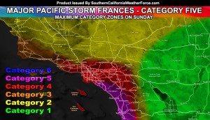
A very powerful storm system that will bring a variety of different weather conditions to the micro-climates of Southern California will impact on Sunday. 18 FT Waves expected in San Diego and majority 12-14 FT elsewhere for damage at the coast is what we’re going with right now, a risk of severe thunderstorms and tornadoes, flooding potential, and mountain blizzards. Your forecast details by reading on … Video included …
Light rain will start in all areas as early as Sunday morning … increasing as the sun rises and fading in many spots as the sun sets … a true daytime event.
Please NOTE that Category Five conditions are subject to a small part of the metro areas of OC/SD with the LA/IE zones having C4 conditions and a sharp decrease in severity north and west of Venture County. This is important to remember because this service zones into these zones with accuracy to show you where the worst will hit. This is a category five at the center, if you are in a category two area then do not expect category five conditions. If you are in a C5 zone … Expect C5 conditions from you within 5-10 miles away.
The storm system will literally cut the forecast area in half from north to south with the southern half getting more severe weather than the northern half. This is all due to a surface low that will set the boundary from northerly and southerly winds into it. San Luis Obispo will not see the severity as with the last major pacific storm… which was Eugene, earlier this month. The area will see rainfall and possible storms, however the tornado potential is looking to be Ventura County at the furthest west … and San Diego/Inland Empire at the furthest south and east. Within this zone …
At the surface, a surface low crossing the bight will bring in the northerly flow out from the deserts and a southeasterly flow in the metro/coastal areas.
This low level spin will work to bring shear into the area and this plus instability will bring the risk of tornadoes yet again this month. Instability is stronger in the OC/SD areas with marginal in the IE/LA/VT areas.
All areas of the forecast area within this advisory have the risk of severe winds, thunder, isolated tornadoes, and flooding.
An upgrade to a severe thunderstorm or tornado watch will be made by Sunday morning if the need arises. This watch is the step before such a decision and as with the tornadic storms earlier this month … the decision will be made based off our models and scientific facts as that system did have tornadoes … as I did forecast.
Rainfall will be in all regions, including the low and high deserts where it usually does not happen with fronts. The reason for this is because the deeper layer moisture is there for the rain to make it over the taller mountain peaks. All desert zones will continue to have gusty winds through now into Monday, the storm statement is taking care of that.
Wave heights of 12 FT along the coast as the lowest will be likely in what could be the strongest El Nino induced west to east swell to hit the region this season.
Wave heights as high as 18 FT may hit the San Diego Coast … with an average of 14-18 FT … Be advised that strong winds, heavy rain, thunderstorms, and waterspouts are also likely with the passage of the front on Sunday.
It is not a good time to go out …
The system will affect the region during the day … exiting blizzard conditions through the SBD/RIV Mountains above 6,000 FT by evening. Over 1-2 FT of snow may fall in the Big Bear zones, as well as the top of the Riverside County and Ventura County Mountains. Wrightwood will see the snow during the middle of the front as well .. .so we’re going with 6-12 there.
As for the Kern County Mountains, activity will start on Sunday morning ahead of the storm system, maximizing over the day … and light snow falling through the night into Monday morning.
PMC could hold over 6″ of snowfall with heavy snowfall on Sunday … and a closure of the Gorman Pass is possible with the lower snow levels through the night.
The model does show over 6-8″ of snowfall in Tehachapi at 4,000 FT … however the custom snow level charts show the bulk of the system at 5,000 FT so these totals may be overdone … with lower valley floor levels maybe having 1-3″ with 2x that at BVS …
Gusty west-northwest winds for ALL areas of the Southern California region will be likely through Sunday night, with winds continuing into Monday … and tapering off on Monday night.
Be advised that this is the free section of the site and limited information, maps, and charts can be placed here. To get full member access with rainfall, snowfall, and other such charts placed for a forecast that you can CLICK HERE and see what all there is to offer. I will be working hard to update everything through tonight and the morning, including tornado zone projects, which will be available by morning.

