
[vc_row][vc_column][vc_column_text]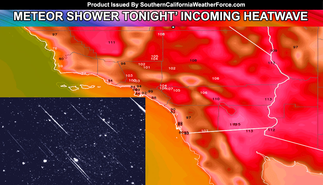
The strongest meteor shower in 10 years hit overnight tonight and the cool start of the month is over … the heat is returning on schedule so read on for details.
The Perseid Meteor shower is expected to bring four times more meteors per hour than usual overnight tonight after 10pm. Around 10pm the Moon will still be out being it’s in a Waxing Gibbous phase and won’t set till an hour or so after local midnight. Meteors will be best seen when the radiant (where the meteors are coming from) rises higher in the sky. This is between 2am and sunrise tomorrow (Saturday).
The weather tonight is expected to have marine layer along most coastal areas that may prohibit viewers seeing the meteors if the plan is between midnight and sunrise. Most mountain and desert areas will be the prime spot to see them .. away from city lights. Moisture levels do not show mid or upper level clouds being any problem and it should be a fantastic show
The ridge of high pressure is building through starting today and will maximize Sunday through Tuesday as the hottest period, with a drop from heatwave levels at the end of this next week.
Here are the expected SELECT CITY values based off our model for Sunday, Monday, Tuesday, and Wednesday … in order …
Riverside – 104 – 107 – 105 – 102
Downtown LA – 90 – 94 – 90 – 86
Fullerton – 96 – 99 – 96 – 93
SFV/SCV – 102 – 103 – 101 – 99
Irvine – 86 – 88 – 85 – 82
Ramona – 96 – 97 – 97 – 95
Bakersfield – 111 – 111 – 110 – 108
Paso Robles – 102 – 97 – 92 – 92
Lancaster – 103 – 102 – 100 – 99
Apple Valley – 103 – 102 – 103 – 101
29 Palms – 105 – 106 – 106 – 103
Indio – 109 – 110 – 111 – 107
Brawley – 113 – 115 – 117 – 110
Blythe – 112 – 113 – 114 – 107
Las Vegas – 109 – 108 – 108 – 100
In addition to the heat, toward the end of this next week in the medium range an upper level low looks to setup west of California and this will put our area in the window for southerly flow to bring back the monsoonal moisture. If the upper level low has divergence with it … we could be introducing it west of the mountains but this decision will not be forecast until at least Tuesday. If you want to stay home you can do it and have some fun with http://xn--ntcasino-0za.co/ . For now we’ll focus on the heatwave .. .[/vc_column_text][/vc_column][/vc_row][vc_row][vc_column][vc_facebook type=”button_count”][/vc_column][/vc_row]