
A weak front will develop in the bight of the forecast area from south of Ventura to Orange County with Los Angeles County at the center overnight tonight and into tomorrow morning, Tuesday. It will drop light rain with it … but for a deeper explanation read on for the details.
A cutoff low dropping south out of Canada is current in Northern California. This cutoff low was the center of circulation of Hurricane Lester not too long ago … which threatened the Hawaiian forecast area. The storm rounded the ridge to the west and is now dropping into California … however it will be blocked from going any further south of Chico, California.
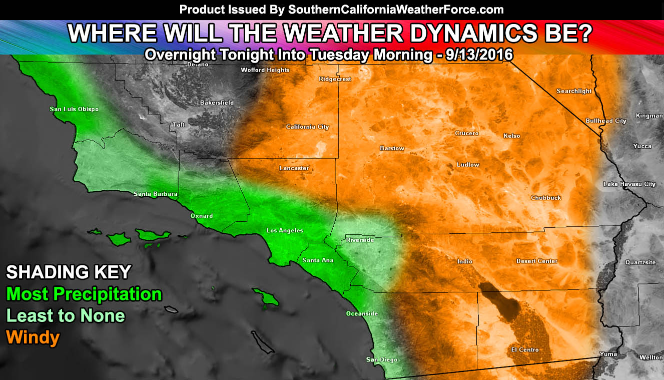
The storm will however up the wind across the mountain/desert regions with 30-50 mph wind gusts from a stronger onshore flow starting today. A SCWF Wind Advisory was issued yesterday and goes from today through Tuesday in those areas.
As for the metro areas … am expecting deeper low level moisture into the region. This will bring taller cloud tops with an increased chance of an actual weak front developing in the bight of the region overnight tonight and lasting through Tuesday morning. This weak front will develop from Santa Barbara and Ventura south into the bight (island ocean region).
NEW: SCWF Weather Alert Facebook Groups By Region – JOIN ONE TODAY!
It is not expected to bring a lot of rain .. but some of our in-house models are projecting this to be the first measurable precipitation, with spots of 0.1″ of rainfall (tenth of an inch) dotted across the LA/OC/VT areas and up to over a quarter inch of rainfall in some foothill zones of Los Angeles County.
The frontal zone will have mainly a southerly type flow so the areas of SBA/VT/LA/OC are the most favorable areas for precipitation and a mist possible elsewhere through the San Diego and Inland Empire areas as the flow does not equal to be strong enough for measurable San Diego precipitation. The Santa Ana Mountains will also block most of the moisture needed for precipitation .. .the exception possibly being those communities along I-15 from Corona to Temecula seeing mist/light rainfall
Do not get use to the taste of Fall .. as stated in previous articles we will warm up after the 20th .. but most likely as early as this next weekend and stay that way for sometime and approach heatwave level status again …