
The heat is on as previously forecast but this will be short-lived as the clouds move in on Monday, bringing with it the risk of shower and even thunderstorm activity. Because of the lack of cold core, the storm will not retain the name Amelia … but will still impact us the same so read on for those details.
The system is just southwest of the Martin Storm Diamond at the current time and is expected to spin out there for 24 hours, gathering moisture from the south near Tropical Storm Paine. The tropical connection with this will make the colder core turn a bit warmer … plus also the flow will not be as strong into the region north of Santa Barbara and Kern County so what we’re looking at is a storm that will not be named because it does not meet the Southern California Weather Force criteria for a named system.
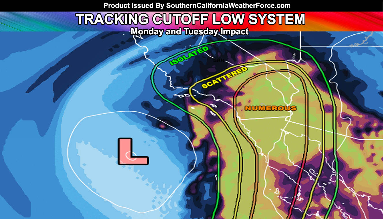
Impacts with this will range from isolated to numerous … cutting the forecast area in half. Isolated shower/thunderstorm activity is possible as far west as Santa Barbara and Ventura County onj Monday given the positive vorticy advecting into the upper divergent zone. This would be a quick hitter and isolated up in that area.
Further southeast into Los Angeles, Orange, The Inland Empire we will be within the scattered activity as moisture would be deeper. Elevated instability looks sort of weak, but enough to pop off thunderstorms on Monday .. along with the risk of rainfall .. sometimes heavy.
NEW: SCWF Weather Alert Facebook Groups By Region – JOIN ONE TODAY!
The thickest part of the moisture plume looks to be San Diego County, Imperial County … and the Colorado River Valley zones … so the heaviest storm activity is going to be expected in those regions. A tropical connection with Tropical Storm Paine will likely enhance the rainfall amounts in these areas along a southwest to northeast axis in the divergent pattern.
Because of the disruption of the circulation of the cutoff low from Tropical Storm Paine … I am expected somewhere between the IE/OC/LA/VT areas having a dryslot. A dryslot means that drier air would limit storm activity for a small part of these regions … at the time I do not know which area as it is a cutoff system .. but what I do know is this dryslot will be in the region on Monday through Monday night.
Lifting associated with the upper forcing of the southerly flow and upper divergent section of the cutoff low will be available through Monday night …
Through Monday and Tuesday it’ll be slightly ‘cooler’ … BUT it will be humid … and not feeling all that well for those sensitive to the humid conditions.
Around the 25th we will have yet another ridge form and temperatures will skyrocket … This was all in the September 2016 forecast … proving that Southern California Weather Force long range predictions were correct once again for the month …