
[vc_row][vc_column][vc_column_text]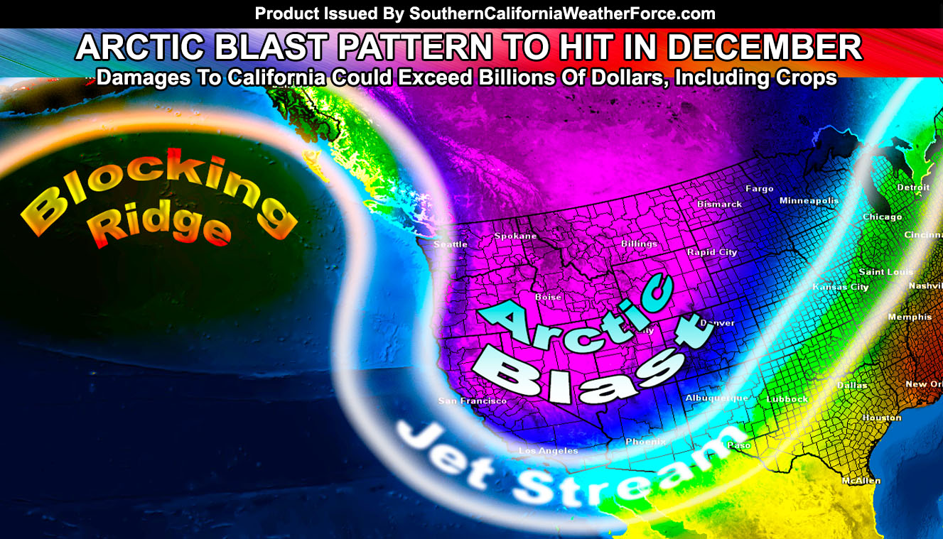
This will be the third article follow-up I write about December and for many weeks now I’ve been looking at a pattern not seen since about 1990 when a blocking pattern set up in the Pacific Ocean and allowed for arctic air to blast southward into California, causing billions of dollars in damage. The last time I did a prediction like this was in December 2008 and Las Vegas, Nevada received 8 inches of snowfall … so read on for details.
We just had our first Pacific Storm into the Southern California area and it was a good one. It brought rain all the way through into our deserts as well. Now that has kicked off we will dry off once again and await the blocking to happen for the beginning of December and a couple more times through that month.
Blocking is a term used in weather when a huge ridge sets up and blocks the atmosphere so that storms are locked in one position for a very long time. Sometimes, like in many year we’ve seen in our past five years here in California, blocking has given us a large ridge directly overhead or a few hundred miles offshore. This made storms miss to the east, sending arctic blasts into the eastern half of the United States. This is what blocking does. You’re either on the warm/dry part in the ridge … or you are in the cold/stormy spot within the trough.
This year is approaching a Moderate La Nina so blocking is apparent in the Pacific. By the starting of December this blocking pattern will develop way out west in the Pacific … not even close to California. The blocking will form south of Alaska. This blocking pattern will send arctic blasts down the eastern side of it and along and offshore the Western coast of Washington, Oregon, and here in California. The due north to south flow is very rare … and very dangerous to our crops.
For us in Southern California, blocking like this gives us our coldest temperatures, even record breaking temperatures. It also provides windows for arctic storm systems to rotate and dive down into our area, giving extremely low elevation snowfall, convective activity for thunderstorms, and gusty wind conditions.
So the month of December is shaping out to be similar to that of patterns for 2008 and 1990.
Those of you in the High Desert regions, including the Morongo Basin and Antelope Valley will be getting a lot of snowfall this December. When a storm system comes down the pipeline of a blocking pattern, it sets up a surface low southwest of Southern California. This surface low sucks in air from Nevada, around Las Vegas. This, similar to a Santa Ana Wind Pattern but with the moisture and cold … brings a north wind against the north and eastern slopes of the Kern, Los Angeles, and San Bernardino Mountains. This creates lifting on the north and east side of the mountains and thus with the colder air … produces heavy snowfall in our High Desert areas so think of it as opposite of Pacific Storm storms that bring south flows and you are left out and Los Angeles is getting all the rain. The lifting is on the High Desert side … or reversed from the normal Pacific Storm flow.
If these surface lows also set up in a way like 2014, 2004, 2008, etc … We will have low elevation snowfall in some valley areas.
Christmas will not be like we normally have with warm/dry conditions. Christmas will be cold .. .feeling a lot Christmas for many in our region.
So as I stated before … this is the third article and I will link the previous articles below for you to read on reference to this extremely long range forecast.
Article One (Calling For December Arctic Blast) – November 8th, 2016
Link to article – https://www.southerncaliforniaweatherforce.com/2016/11/08/heat-and-storms-long-range-to-finally-open-storm-window-for-southern-california/
Article Two (Follow-up) – November 19th, 2016
Link to article – https://www.southerncaliforniaweatherforce.com/2016/11/19/attempting-weather-forecast-history-weather-pattern-signals-major-change-now-through-the-end-of-the-year/
[/vc_column_text][/vc_column][/vc_row][vc_row][vc_column][vc_facebook type=”button_count”][/vc_column][/vc_row]