
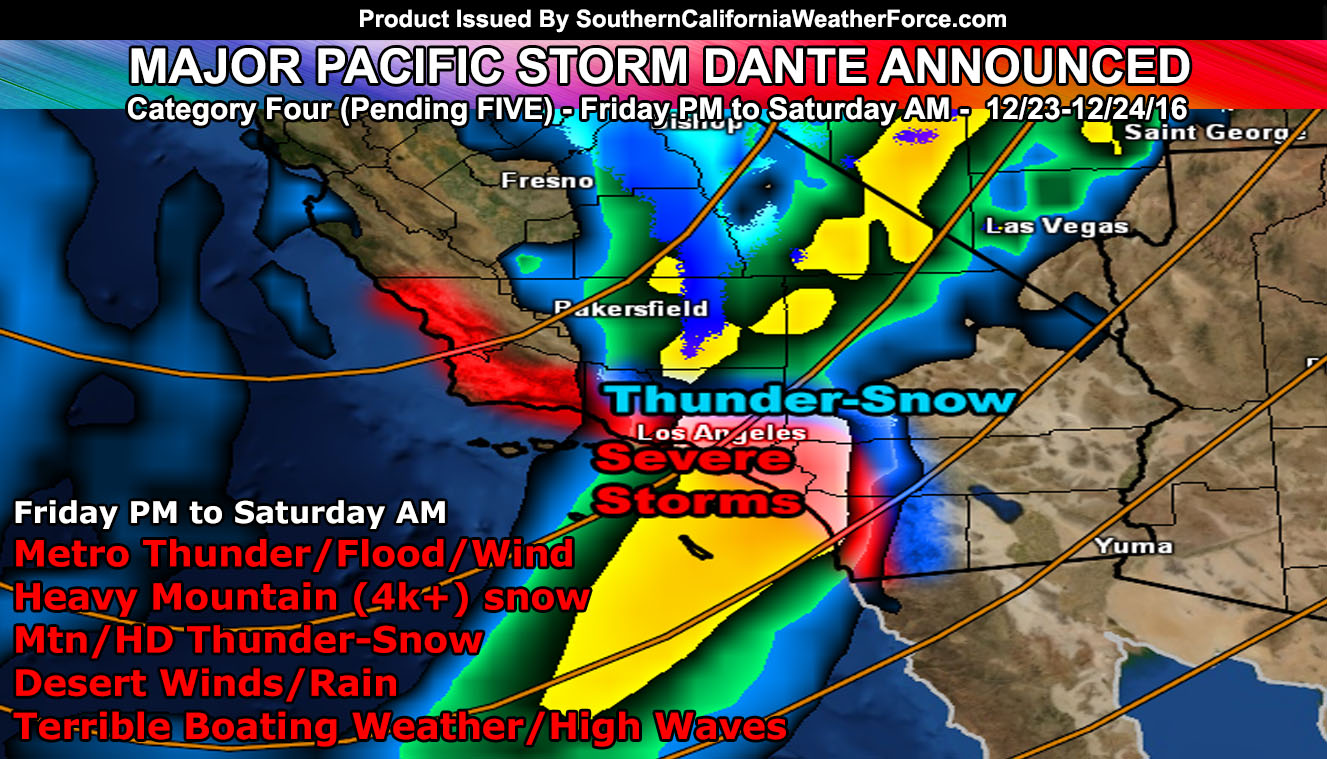
Major Pacific Storm Dante is now official and the starting category for him will be a Category Four … out of six … he’ll harbor ares of heavy precipitation, severe thunderstorms, and gusty winds at the center. He could try to run for category five but it will depend on the next 12 hours to make that call by Friday morning.
Major Pacific Storm Dante will enter the forecast area on Friday afternoon for San Luis Obispo/Vandenberg and sweet eastward through the evening/overnight into the metro Los Angeles, OC, IE, and San Diego surrounding areas. Already I have issued a Flood Watch as of Wednesday for this event … which can be viewed here.
FACEBOOK PAGE: Haven’t liked it with almost 40,000 people on it in a year getting these products?
CLICK HERE TO CHECK IT OUT!
In addition to the Flood Watch … the higher class Blizzard Watch is also in effect for the Los Angeles, Riverside, and San Bernaridno Mountains above 4,000 FT … There is a high likelihood that due to the lower snow elevations that resort levels could see between one and two feet of snow, making it a perfect setup for after Christmas winter sport outings.
There is a chance that slightly drier air will work in for the risk of High Desert metro snowfall behind the main front … so it is very possible this might be the December storm I saw sine November 8th … but it still isn’t satisfying me in terms of how much I expected and January looks to be yet another shot of it … as this year is the pattern for such a High Desert snowfall event.
Winds along the frontal zone will be gusty in all areas … with the concern for frontal zone winds + thunder adding up in the metro areas for the risk of calling it a Severe Thunderstorm Watch should the time come.
Through this event we’re looking at 1-2 FT of snow possible for Wrightwood to Big Bear Lake … 6-12″ for Idyllwild … 1-4″ for Tehachapi, Gorman, Cajon Pass, and Pine Mountain Club … with 4-6″ in Julian, and 1-3″ in Warner Springs. I also will go ahead and push for Thundersnow, especially in the Ventura, Los Angeles, San Bernardino, Riverside, and San Diego Mountains …
Everyone else is going to have to click the link and go to your micro-climate section and await the alerts that come. Some are out now … and others will be issued.
Click Here To Go To Your Micro-Climate Section –
Full Members can see the snow level, snow amount, flood risk, rainfall maps, by tomorrow morning before Dante hits … Don’t miss out! … Click Here To Enter the Member Section
See ALL the alerts I issue here – https://www.southerncaliforniaweatherforce.com/