
The numbers have been crunched to find when the hottest and coldest periods over the next month will be, as well as the official SCWF forecast for Summer 2017, which analogs similar to the Summer of 2009 … read on for the details.
Dangerous heatwave to impact inland Southern California starting this weekend and lasting into this next week gains strength from previous forecast numbers with temperatures over 105 for the valleys and temperatures as high as 118F for Bakersfield. Read on for details.
What is known at this time of year as a monsoonal heat-blast is about to strike the Southland. A monsoonal heat-blast happens near the start of the Southwestern United States Monsoon when the first southeast flow hits. When this happens, the onshore flow, or mother nature’s air conditioning we are use to, goes away … and is replaced by a dry southeast flow.
LIKE US ON FACEBOOK for updates! Click Here and join thousands …
Because this southeast flow comes from the land and not the ocean … is the reason for the lack of cooling and thus hotter temperatures. This however does not mean we will see any moisture from this heat-blast. It marks the start of the Southwest Monsoon for areas like New Mexico and Arizona, with weak intrusions at first, gaining steam through July.
Temperatures starting this Friday will be well above average and Summer like in all inland areas. Triple digits in the valleys is certain, with the same across the deserts. By Tuesday, temperatures in the Inland Valleys will be 104-108F with temperatures as high as 118F for Bakersfield … Yes you read that right, 118F for Bakersfield.
110F will be breached in the inland areas by Wednesday (21st).. the official start of Summer.
Coastal areas will remain in comfortable conditions …
This type of heat is dangerous so you will need to prepare now …
This heat will subside toward the end of the month under strengthening low pressure in the Eastern Pacific. Because of this, onshore flow would return to our region. However, sometime around July 4th, the ridge would build back in and the heat would come back for a brief period of time. Cooler conditions would then hit by mid-month as a strengthening east-southeast flow in the mid-levels brings the official start of the monsoon for the Southwestern United States. Would call it a semi-late start for this year’s monsoon.. but Mid-July is when we will see it start up.
After the 20th we will get a heatwave pattern returning, with cooler weather toward the End of July.
Overall July seems to be average to slight above average in temperatures …
July will be opposite of what July 2016 was and this anomaly will impact what the Summer overall will be like, leading into the winter season.
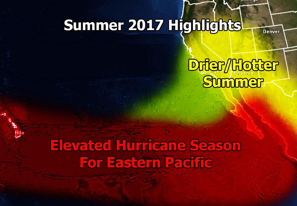
Cooler sea surface temperatures in the Eastern Pacific promotes less tropical storm/hurricane activity in the Eastern Pacific Basin in July so unless we get a flow out of Mexico through the Gulf Of Mexico we should remain drier for the start of the monsoon… Should sea surface temperatures warm as I expect through August – October, the risk of hurricanes in the Eastern Pacific would be high and thus the Pacific Hurricane season would once again out-due the Atlantic season.
However, a cooling off our coast and a bit south would not let many hurricanes get close to our area, thus I’m thinking that overall the Summer will be hotter than normal … and drier than normal.. with yet another lackbuster monsoon showing up in the region.
The analog that matches the current Summer for us is 2009 … which did run into the 2009-2010 storm season.. an exceptional rainy season for us in the Southland coming up … should these numbers continue … but we have to get through yet another drier than normal summer.