
Various modeling aspects here at Southern California Weather Force are not agreeing with each other, as is the case for monsoonal moisture. Some have storms into Ventura/Los Angeles and Vandenberg while others hit the Inland Empire and surrounding Mountains with the high/low deserts as well. Read on for those various scenarios.
Scenario One
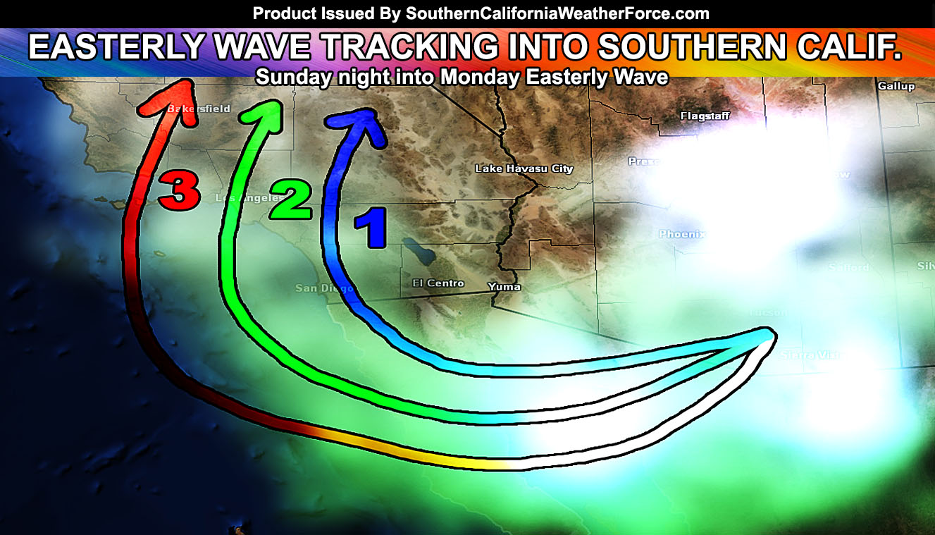
This scenario shows outflow coming out of Arizona and curving over the Baja, Mexico mountain areas, finally northward into the San Diego, Riverside, and San Bernardino Mountains, possibly even the Inland Empire on Sunday night into Monday. Again, it would bring the risk of shower/thunderstorm activity with it.
LIKE ME ON FACEBOOK for updates! Click Here and join thousands …
Scenario Two
This scenario shows outflow coming out of Arizona and curving just west of Baja and into the San Diego, Orange, and Los Angeles forecast regions on Sunday night into Monday. This scenario would almost be preferred for the current outlook on where the easterly wave is now and what it ‘should do’ … and this would cause shower/thunderstorm activity in those areas.
Scenario Three
The last scenario shows outflow coming out of Southern Arizona, rounding an easterly wave, and finally entering Southern California’s bight (island region) on Sunday night into Monday. This type of scenario would need to shove offshore from Baja, Mexico and curve north into those areas, which would be the Vandenberg Air Force Base / San Luis Obispo / Ventura / Kern County forecast zones. It would also interact with an upper level low that will be parked just outside of San Francisco, which does help with mid-level instability for shower/thunderstorm activity.
Click Here To Find Your Zone On Facebook For Updates Now and In The Future
Click Here To Find Me On TWITTER.
What is learned so far?
What is learned so far is that the easterly wave starts in the same area of Arizona. It shoves outflow out of it and surges westward toward and over Baja, Mexico. What it does then is unknown at the time … however one of these scenarios above is going to happen. The timing is also the same with a Sunday night to Monday impact into our region. All scenarios have mid-level instability, which does elevated the thunderstorm risk.
What is more likely?
Crystal ball has nothing definitive but if I had to take a stab at it this far out with a monsoon intrusion I’d say Scenario One or Two is the closer one because it is the median of all my model numbers.
What I do not think?
I do not think this will miss any scenario or Southern California altogether. I’m confident in such a curve into our region with such an outflow boundary and possible gravity waves from Arizona’s storms, which hit them on Saturday.
When Will I Know?
On Saturday this easterly wave will eject out of Southern Arizona. The angle at which it ejects will allow me to make a definitive decision on where to take it into the forecast area.