
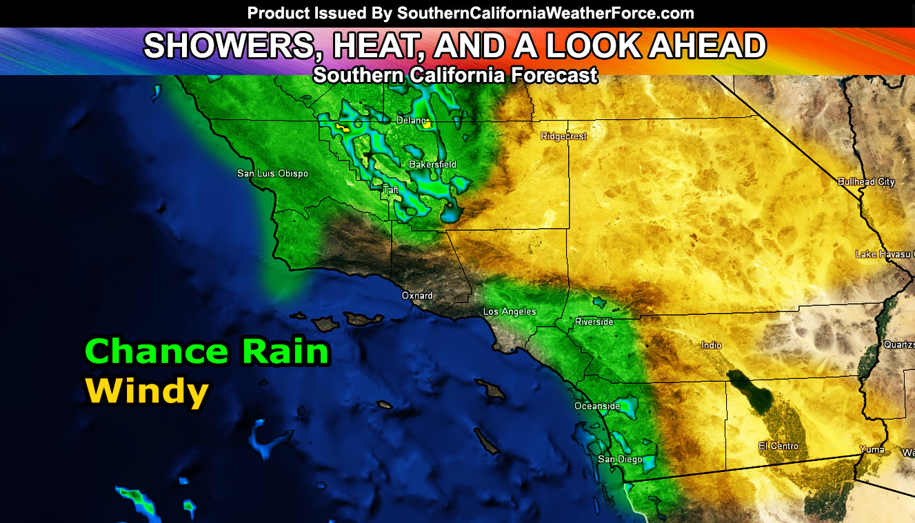
The passage of an impulse overnight tonight into Friday will bring some areas showers and some areas gusty winds, switching offshore by Saturday with the start of the warm up. Read on for details to see if you’re in a target zone forecast …
An impulse will move through the area overnight tonight and into Friday, bringing an upswing in shower activity in the short term forecast zones. This type of west to east flow would bring more accumulations on the south and west facing slopes of the mountain/foothill and adjacent valley areas than areas far from them.
LIKE ME ON FACEBOOK for updates! Click Here and join thousands …
I did shade the Inland Empire in it, however there is a chance that this would be for areas north of Norco/Corona and east to Hemet with the higher accumulations. Rainfall also will accumulate on the north and west slopes of the Kern County Mountains, including the Gorman Pass.
Premium Members: Click Here For The Zoom In Maps Of The Rainfall Prediction in your member section.
An impulse moving through the area from west to east will bring sinking air behind it. This will increase the winds in the advisory zone overnight tonight and last into Friday, the strongest being early Friday morning before sunrise.
Wind gusts of 30-50 mph will be likely with the strongest on the eastern mountain slopes and near the Mojave, CA areas … east to Barstow …
Premium Members: Click Here To Enter Your Member Section and hit Wind Model for this event …
In the longer range it is becoming more worrisome with continued dry conditions. We have yet to see a major storm move down here before Halloween and a typhoon is usually the cause of continuing our dry weather. The reason for this is because it interacts with the northern jet stream and send arctic air down into the Eastern half of the United States, while we get baked in the ridge. This looks to be the case with the next heatwave as by Monday and Tuesday the Inland metro areas under the strong ridge and offshore flow will bake into the 100-105F mark.
I started a new project that is free to view as it is experimental right now. The product takes a target event and 20 of my models and will show out of how many of those are showing the event targeted. As of yesterday we had 6 out of 20 showing a storm between the 27th and 31st of this month. However today that has gone down to 3 out of 20. Confidence in the end month storm pattern is fading… all in part due to that pesky typhoon that is throwing a wrench into the pattern.
What I hope this isn’t is the start of a pattern trend because of it is you can kiss our wet winter goodbye and thank that typhoon for it. Should this happen we’ll continue to see the arctic blasts hitting well east of us. However, I’m not ready to pull the plug on the strong season just yet. I’ve seen some years where a typhoon failed to spin the pattern permanently … but what I can tell you is this year looks to be highly dynamic, with multiple shots of cold air, cold storms, warm storms, Santa Ana Winds, and thunderstorms, whereas last season had storms … but the majority were warm storms due to the fast Pacific jet influenced by the El Nino pattern, which will not be the case this rainy season.
If we see the same pattern through THREE WEEKS in November … We will hit a 2006-2007 season, the driest on record. Let’s hope for something to change.
Click Here To Find Your Zone On Facebook For Updates Now and In The Future
Click Here To Find Me On TWITTER.
VISIT THE MEMBER SECTION FOR 2017-2018 SEASON – SIGN-UP OR READ ABOUT IT HERE