
January 2018 will yield some storm activity, but opposite in what a winter should be like. I’ve been in the hospital for a week after having went off my office roof from my second story home. I am in one piece. However, find out the rest of the month forecast and more by reading on …
First and foremost I’ll go into where I have been. Granted we haven’t seen much weather in my absence, we will start to see our first real storm system very soon and I’ll be around to forecast it for you. The day after Christmas I went off my office roof and broke my right foot (almost all metatarsals) and sprained my left foot very badly. I am recovering, however at the time getting around the house and office by using my arms. It’s not so bad … as I adjusted quickly. I have to continue work and go on living so this won’t stop me … almost nothing will. So .. now I’m back.
Now onto today and tonight, into Thursday morning. There’s a gliding frontal zone that will move through the San Luis Obispo and Santa Barbara County regions. A gliding front means a front that moves northeast instead of due east, impacting areas well west of Los Angeles and leaving the other locations mainly dry. This happens when a ridge to our east bulges enough to prevent it from moving east … and defects it northeast. Under a quarter inch of rain is expected in those zones I listed (SLO/SBA)…
If it does not say “Liked” LIKE The Page Below and join thousands of informed weather forecast viewers in our region for more of the updates!
If you’re in the San Francisco Bay zones, eastward to some outside cities along I-5, you can note that upper dynamics and instability favors thunderstorms overnight tonight so don’t be surprised if you are surprised it happens …
Sometime next week we will see our first real chance of our first storm system, almost on par to what I was thinking the start would be based on my thoughts that this is a mid to late rainy season, similar to the 2005-2006 season.
HATE THE ADS or Love the Forecasts and Want To Support The Work To Help it Stay? Become a premium member and support the service and receive forecast perks as well …
Click Here To Learn More …
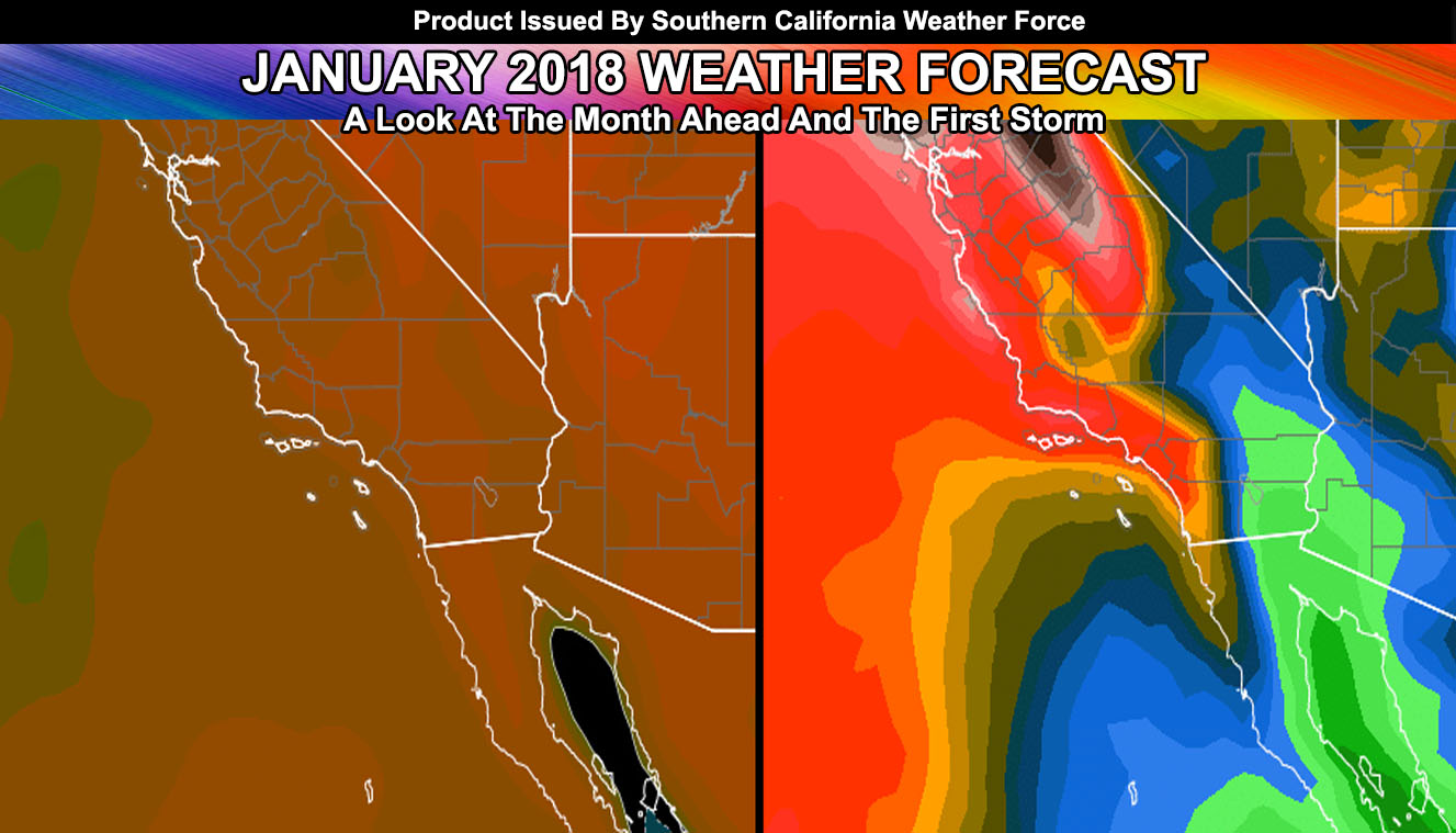
The system next week looks to be angled as such and the origin lacking Alaskan flow will likely be one that brings upper resort to high snow levels. It does not, at the time, look to have a major snow impact for most mountain communities. Further indications are this system will impact the areas in IE/LA westward with more rainfall .. .than areas south into San Diego. San Diego would still receive good rains.. more than you saw this season thus far.. as will everyone else.. but the impacts will greatly affect the Thomas Fire zones more.
Right now there is a 50 to 60% chance of 1″ or greater rainfall from next weeks system in Los Angeles. This is a high value for a week out and is telling me to continue to monitor the pattern for it.
We remain drier and warmer than normal for most of this month.. with the next system possible by end month … All and all 1-3″ of rainfall is possible for Downtown Los Angeles this month.
Given the evidence and pattern I see at the current time, January will be below average in precipitation.. and above average in temperatures.
Click Here To Find Your Zone On Facebook For Updates Now and In The Future