
If you were living in Southern California in the 1990s, you probably know that Wednesday is the 24th anniversary of the Northridge earthquake. Where were you when it happened? I was in bed awake for some reason, almost like I detected it before the main one hit 10 seconds later. Read on for details, including Friday’s cold front.
On this day in 1994 at 4:31 a.m., a 6.7-magnitude earthquake struck.
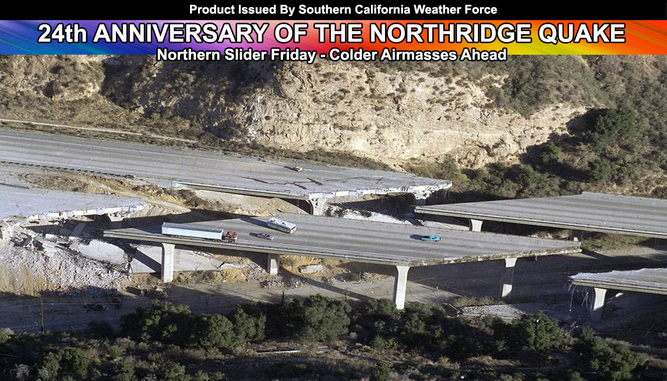
Freeways were flattened, buildings and apartments were pancaked and gas lines were broken, starting more than 400 fires.
Over the next weeks and months, there were thousands of aftershocks, some measuring as strong as 6.0 in magnitude.
When the dust settled, 57 people had died and billions of dollars in damage was left behind. It took years and nearly $50 billion to rebuild.
The quake’s epicenter was actually Reseda, but it took several days to determine that.
If it does not say “Liked” LIKE The Page Below and join thousands of informed weather forecast viewers in our region for more of the updates!
The Northridge quake was an interesting one. The fault that produced it was called a blind-thrust fault. The fault was many miles down and not visible at the surface. So in other words it was a hidden fault that we could not detect. The fault pushed the land upwards as it went off, creating a tidal-wave ripple of ‘sand-waves’ underground that spread for many miles. It displayed the ground more than 20 FT in some locations, making it one of the most powerful Earthquakes to hit California. In comparison, the San Andreas Fault is a strike-slip lateral fault, which means the land shifts side to side around it. The Northridge quake’s thrust fault shape made the land shift up and down.
Now for the cold front? Taken from the member section update since it is nearly the same.
On Thursday, expecting the first hint of the front hitting the SLO/Vandenberg regions lightly in the evening/early night hours. This increases for the Kern Valley zones over the morning on Friday, lasting into much of the day. Northwest flow will bring the highest amounts in the Southern California region in the Kern County Mountains, on the Northwest and west facing slopes. Later on Friday the frontal zone brings in a strong onshore flow for a chance of isolated showers in the LA/OC/SD/IE zones, the most being in the south and west facing foothill zones and valley metro areas.
HATE THE ADS or Love the Forecasts and Want To Support The Work To Help it Stay? Become a premium member and support the service and receive forecast perks as well …
Click Here To Learn More …
Cold air behind the front will be widespread inland frost, with freezing high desert and Kern Valley temperatures. Advisories/Warnings will be needed later for that.
Snow level on Friday drops through 4,000 FT for the Kern areas, later Friday to the Cajon Summit, and through 4,500 FT for the Riverside Mountains Friday evening/night. San Diego Mountains could end Friday later evening with 4,000 FT snow levels with departing light snowfall… but the best bet will be 4,500 to 5,000 FT snow levels, non-sticking 3,500-4,000FT and sleet at 3,000-3,500 FT. The higher amounts of snow will be reserved for the Kern Mountains areas, including the Bear Valley Springs and Cuddy Valley forecast zones.
Thunderstorms with the front do not look likely, however on Friday afternoon/evening there is a small section on the back-side of the trough. Gathering low/mid level moisture along with the cold air aloft could make it possible for thunderstorms to form on the SLO/KERN County border areas, McKittrick areas westward along the elevated zones on the border zone. Further monitoring will be done as we near Friday.
Surf will wind down this week with a departing mini-swell however surf will be up through 4 FT in the OC area by Friday morning, peaking to over 7-8 FT waves by Friday evening with the cold-front moving in, as well as strong west winds at the coast. Lack of wind on Saturday will bring the waves back down below 3 FT in that area. Santa Barbara’s coast will have 12 FT waves by later Thursday and lasting through Friday.
Wind alerts will be needed in almost all sectors of the forecast area with Friday’s cold-front and strong onshore flow winds.
Weather Event Agreement models are continuing to weaken the long range even more, and rain is slowly moving out of my long range forecast. Confidence remains low at the moment for any further alerts and I’ll remain to focus on Friday’s system.
Click Here To Find Your Zone On Facebook For Updates Now and In The Future