
A northern slider is set to come in, bringing a variety of micro-climate induced weather effects so read more for the details on what to expect and if you are an area of interest …
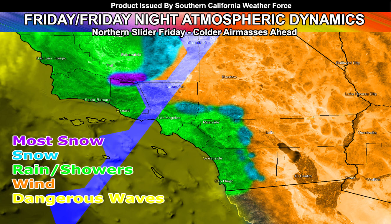
A weak disturbance will come into the LA/OC/IE/SD areas, including the surrounding mountains there by later this afternoon and lasting through the evening.
Showers are likely with the uplifting, with most of the accumulation near the foothill zones and lighter amounts as you go toward the coast. The mountains surrounding the Inland Empire, including Big Bear Lake, at this point are not needing a Winter Weather Advisory from me due to the fact that a lack of moisture above 10,000 FT just doesn’t spell anything more than a dusting in our mountains.
If it does not say “Liked” LIKE The Page Below and join thousands of informed weather forecast viewers in our region for more of the updates!
Gusty winds will accompany the front this evening and tonight along the coast with 20-30 mph wind gusts possible… with up through 40-50 mph gusts in the mountain areas …
Member snow level charts are in the member section as well as the final snowfall model. This will clear later tonight with some areas in the Inland Empire dropping into the 30s. Saturday night will be the coldest night and many freeze warnings/advisories will be needed then.
Some changes to the forecast this morning with the snow track numbers has brought down some snowfall totals, but snow is still expected on the Tejon/Gorman Pass, PMC, and Tehachapi Mountain range today through Saturday morning.
Snow model here is bullish this morning on amounts, which I’m not sure I totally agree with right now. We have a strong low level jet coming into the Tejon/Gorman pass tonight. This low level component should act as a sponge and squeeze all the moisture out of that pass and the PMC zones.
Right now the model wants up to 2″ in the pass with a dusting in Tehachapi, 3″ just west of Woffard Heights, and up to 4-6″ in PMC. This seems correct given tonight’s low level wind component, which will favor the Southern Kern Mountains near the Tejon/Gorman Pass.
HATE THE ADS or Love the Forecasts and Want To Support The Work To Help it Stay? Become a premium member and support the service and receive forecast perks as well …
Click Here To Learn More …
Should a bit more lift be provided, those numbers would be higher than my model shows.
So with that bring said I’ll do a final advisory for winter weather with snow falling at 4,000 FT this afternoon, 3,000 feet and below by tonight .. and gusty 30+ mph wind gusts … which will bring blowing snow to the PMC and Gorman zones tonight into Saturday morning.
4 FT in the OC area by Friday morning, peaking to over 7-8 FT waves by Friday evening with the cold-front moving in, as well as strong west winds at the coast. Lack of wind on Saturday will bring the waves back down below 3 FT in that area. Santa Barbara’s coast will have 12 FT waves by later Thursday and lasting through Friday.
Issued a High Wind Watch for the I-5 Corridor in Santa Clarita for Friday night into Saturday. A northern slider will move through the area on Friday. The winds on the backside of the system will work with very cold air on the Tejon/Gorman Pass as they get handed by heavy snowfall.. and with it overnight on Friday into Saturday will bring a round of very gusty winds down the I-5 Corridor in a classic I-5 corridor wind event.Wind gusts over 50+ mph will be likely on this corridor, including Castiac and Santa Clarita. Winds like this can cause some damage… and if you don’t want something blown away then take it inside.
A mostly dry front will move through the area later this afternoon/maximizing overnight tonight, bringing gusty winds across all desert zones.
One thing I’ll note is stronger uplifting from upper divergence across the Los Angeles Deserts to Mojave, along Highway 14 later on this afternoon or early evening before sunset. This area may bring convective activity and thus likely the only area in this advisory that would see some rainfall.
The rest of the desert areas will see 30-50 mph wind gusts through the evening/night and into Saturday morning, dwindling down over the day. 60+ mph wind gusts are possible in favored eastern slopes of the Kern Mountains near Mojave.
My medium range models are not showing much for the region.. possibly another northern slider next week however. Long range shows my models trying to group centering the start of February, around the 1st. This is the next time-frame of interest and it’ll be further monitored on.
Stay tuned to Southern California Weather Force for additional updates with any of these links below.
Click Here To Find Your Zone On Facebook For Updates Now and In The Future
Click Here To Find Me On TWITTER.