
That is right, the hurricane is now a category two and rapidly will make category three by this evening. There is a chance that the cutoff system that will drag her northward could be officially named the first Pacific Storm here at Southern California Weather Force as we resume the list we left off on and the next is OPHELIA. Read on more on how these two systems are expected to merge dynamics by October 1st …
Hurricane Rosa is rapidly intensifying and has a clear eye and eye-wall structure. The hurricane is very healthy at the moment. My long range values continue to show the turn northward and then into the Baja, Mexico areas, affecting the CA/AZ border in my forecast area of responsibility. I have gone ahead and issued a flood watch (link) for Imperial County and CO River Valley areas. Phoenix is not my area of responsibility, however I would give you a flood watch as well if I was.
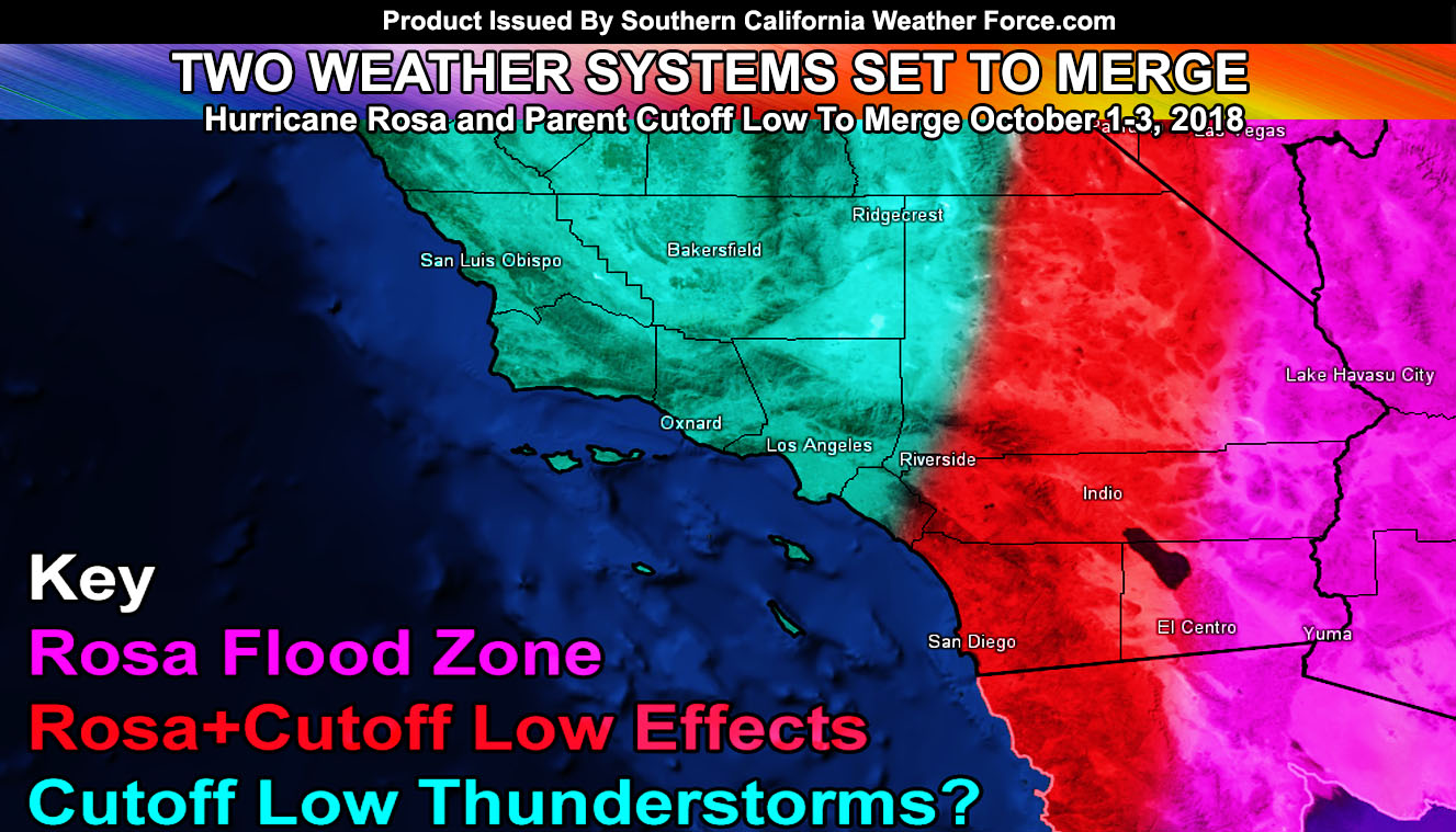
Hurricane ROSA will move into the region as a tropical storm by October 1st. Rainfall will begin out ahead of it later on Sunday the 30th in the watch area. The increased rainfall through the 1st will bring flooding conditions in the watch area, with the CO River Valley seeing 3-5+” in a short period of time. Imperial Valley may see 1-2″. Driving on back roads and highways is NOT recommended during the watch period. Be very advised that this is a dangerous situation and must not be taken lightly. Premium members can check the zoom-able map to see where you reside in getting the most or least rainfall from this event by looking below.
This hurricane will weaken to a tropical storm when it enters the United States. She’ll be pulled up by a cutoff low that I expect will form over the weekend, intensifying through early this next week. This cutoff low will be an interesting feature because it does contain a cold-core. A cold-core can create the risk of thunderstorms, which would be more prominent in the LA/VT/SBA/SLO/KERN county zones than anywhere else. The exact track of such a cutoff low will not be known for a couple more days.
Ongoing Ad – The Southern California Weather Force has a member section with rain, wind, thunder, tornado etc models that are personally updated by me with each Santa Ana Wind or storm event. You also can get e-mailed alerts via a slew of micro-climates. Usually $50 a year the price has nearly been cut IN HALF as the discount that will go through till the end of September 2019. This is a yearly discount that I do so if you are a monthly contributor of $5 or $6.50 then I would upgrade to this and do it yearly each fall and you’ll save more.
Deal ends at the end of this month (September) so Click Here To Join or Upgrade Via The Member Section
Please remember if upgrading to CANCEL YOUR PAYPAL PAYMENTS. Login and cancel the reoccurring payments.
The cutoff, if it continues as projected; will be officially named by me Pacific Storm OPHELIA, the first name on the continued list here at the Southern California Weather Force. This would be the second earliest system to be named. The earliest system named would be the severe thunderstorm producing Pacific Storm Avery in September 2007, which brought a light show across Downtown Los Angeles in the evening and night.
NOTE: Naming and Categorizing Pacific Storms has been done by me since before 1999. Read how I do it by Clicking Here.
The timing of pending Pacific Storm Ophelia is October 1st through the 3rd. Should this cold core move directly overhead I will need to issue thunderstorm watches as thunderstorms would then become probable in sections of the forecast area. Right now it is too far to tell where it will directly go with higher details. My details will come as I issue the watches so of course if you are on the various FB groups I have for your micro-climate zone and/or on the e-mail alert system for premium members.. then you will get the notice on time. What I see right now is this cutoff may very well move directly over Southern California and produce widespread shower/thunderstorm activity and bears continued monitoring.. as I will do.
Surf will be up in all areas with a strong southerly swell for 8-10+ foot waves starting Sunday night, peaking Monday, and weakening by Tuesday. High Surf alerts will be needed via the SCWF Alert System.
Should what could be Pacific Storm Ophelia move across the area, the northeast flow behind the system would interact with the area’s terrain to bring about a round of Santa Ana Winds toward the end of this next week. There is a lot to monitor and I will be working very hard to continue bringing you the best lead-time and most accuracy that can be done on my side.
As for the Miramar Air Show, we are still looking at a steady onshore flow through the event with low clouds/marine layer in the area along the coast and inland. At times the cloud deck will be too low to really enjoy much and there will be light rain/drizzle from the low clouds.. but at times later in the morning/afternoon it could briefly clear to the coast. No gusty winds or high temperatures expected …
TROPICAL STORM SERGIO: This system is next in the line and will form by September 30th. The exact track will determine what forms in our area but it looks like via my numbers it could track in the same area Hurricane Rosa is tracking. It may be a contender to the weather pattern of the Southwestern United States by October 9th.
For the situation on Hurricane Rosa and what could be Pacific Storm Ophelia.. stay tuned to Southern California Weather Force…