
The most powerful and the last impulse of Major Pacific Storm Trump hits the area tonight with a start off … but races through on Thursday morning. This system will push snow levels to over 9,000 FT and this is a tropical laden Atmospheric River flow. Member section precipitation charts shows this is not one to take lightly even out of the burn areas so read on for details, including the SLO/Santa Barbara Severe Storm Watch …
Widespread 1-2″ rainfall amounts with just this impulse will be likely in all sections of the warning zone, with the exception of parts of the Inland Empire area around Canyon Lake and Perris where rain-shadowing effects from the Santa Ana Mountains would bring a bit less rainfall totals there. There is also a risk of thunderstorms in parts of the watch area, with better chances Los Angeles westward to Ventura and less strikes elsewhere.
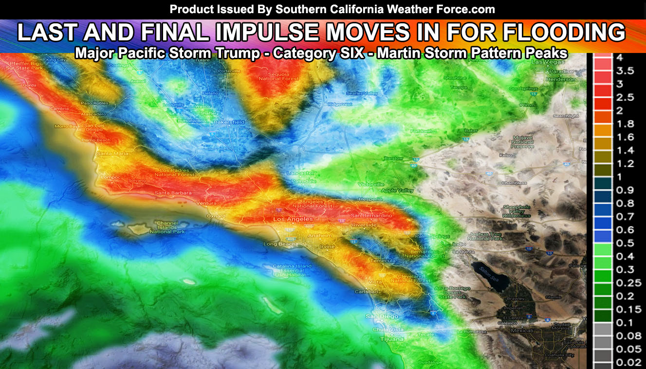
This is a worst case scenario in spots where snow fell at lower elevations and it will melt with higher snow levels in a tropical type atmosphere indicated of El Nino’s effect and sending it into the rivers, washes, and creeks. Some burn area amounts as followed;
Holy: 1-2″
Cranston: 1″
Malibu: 2-3″
Ojai and Montecito: 3-4″
The rest of you can see the images below for the rainfall amounts expected. Premium members can zoom into their house area – Other viewers can click the images below for a larger outlook. This is experimental.
In addition to the the flooding, I’ve gone ahead and issued a Severe Thunderstorm Watch for the San Luis Obispo and Santa Barbara County zones where the best dynamics for thunderstorms will be for this final impulse: Lightning well offshore is being detected a large numbers. This is along an elongated northeast to southwest front that will aim the area between this evening and overnight tonight into Thursday morning. Wind gusts with it will reach severe limits and with higher instability we will see numerous lightning strikes within the watch area.
The ingredients for surface-based updrafts is offshore at the time, precluding the need for a Tornado Watch at this time, however the other ingredients are there and thus there will be a risk of tornadoes with ANY severe thunderstorm moving through. Torrential downpours with this will make a flood issue …
Kern Mountains you also have a flood advisory from me; With such a high snow level, no communities will see snowfall with the coming system starting later today, peaking tonight into Thursday morning… Flood advisory thresholds have been met in the Gorman/Frazier/PMC/Tehachapi areas with high risk detected for a ‘warning’ in the Lake Isabella zones.
There could also be thunderstorms associated with this in spots.
Overnight on Thursday into Friday morning, the rain should continue, but light … with a northwest wind flow.
Kern Valleys.. you may get a thunderstorm from the San Luis Obispo Watch, but I am continuing to monitor for any watch issuance. That should come this afternoon if needed for overnight tonight into Thursday morning.
Imperial Valley. Sorry.. This is a classic rain-shadow event for you as it is for the Morongo Basin. However with the calm winds and recent rains that fell you will be getting dense fog this evening into Thursday morning, thus my Dense Fog Advisory is well in place.
This will do it for the article as Major Pacific Storm Trump is about to come in. Take a look at the images below for this event and click whichever captioned one works for you. All alerts are put into their county locations and that as well can be found by Clicking Here.


