
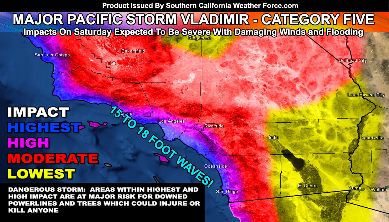
Well, that is it. Major Pacific Storm Vladimir is now official here at Southern California Weather Force as a Category Five system out of my one through six scale for Saturday. Some interesting aspects within the frontal zone is the low-level wind associated with it. Very strong southerly flow will up those rainfall totals yes, however, we are looking at the very chance that with the torrential downpours will come very strong winds in excess of 50-70 mph in our metro areas south and west of the mountains. This would mean that with the falling rain and the wind, the ground being saturated would make for downed powerlines and trees. If you have a garage I would suggest pulling your car into that for Saturday or you’ll have a nice shiny pole or tree playing WWE Suplex Slam on it and when you go outside you’ll look like Clark W. Griswald on ‘Christmas Vacation’ when Cousin Lewis torched his tree and instead of “My Tree!” you’ll yell “My Vehicle!”. To find out the details read on, including those 15-18 foot waves I am predicting! …
This is the article that will give you some of the interesting details surrounding Major Pacific Storm Vladimir. Pacific Storm Ursula is exiting the forecast area this evening and she brought the expected thunderstorms across 90% of the Southern California Weather Force Thunderstorm Watch zones. She’s done and over with so now we move to Vladimir. You have time to prepare on Friday as it looks to be mostly a down day.
By later Friday evening into the night the lead section of Major Pacific Storm Vladimir moves into the San Luis Obispo zones and slides overnight into Saturday morning through the rest of the forecast area. The deepest tropical moisture plume will be over the day on Saturday and numbers have shown this to be an extreme flood risk in every burn area from Santa Barbara to San Diego and in-between, including the Holy Fire areas. This is a full Flood Warning before my actual official one goes out.
Snow levels look high with the initial bulk of the moisture. I can see them being well over 7,000 FT for the most part which is why I am holding off on a Winter Storm product. This southerly flow will be so strong that it could actually warm the resorts up just as the main bulk of the precipitation hits and if that happens kiss a blizzard goodbye. However, after the front starts to pass the snow level would plummet to the 6,000 FT level so of course, the end of the system could have ‘some’ snow.. but I do not expect the damaging wind portion to have snowfall at the resorts thus the Flood Warning will also be for the local mountains.
There is some low-level shear from Santa Barbara to San Diego so I could conceivably see where non-thunderstorm producing waterspouts could develop and move briefly onshore. These happen more than you think so if around the area keep the eyes peeled on your Saturday.
The graphic in this article is for wind+rain danger and the red, or moderate, is indeed for strong wind gusts as well for Saturday.
DANGEROUS WAVES: Major beach erosion and damage to piers will happen with this system. I am predicting 15-18 Foot Waves in the entire forecast area with such powerful swell from this system. This will continue well behind it as well up until Wednesday of this next week so this is a prolonged event wave-wise.
Sunday looks like hit and miss showers for all zones of the forecast area except the high and low desert. Residual snow levels remain at 6,000 FT then.
Next system, the smallest one, comes in Monday into Tuesday and this one is a bit far away at the moment to talk about. Snow levels look around 5,000 FT at the moment but not much is expected.
A break will happen by mid this next week and then we return thereafter the 11th or 12th as we continue what will be an active month for storms.
Stay tuned to Southern California Weather Force on Facebook (Click Here) for official forecast updates …
We continue this pattern off and on for a while so click here for that article
End
NOTE: Premium members. If you are signed up, your login is your e-mail address and the username and password as the password. You can change the password
Ongoing Ad – The Southern California Weather Force has a member section with LIVE UPDATES FOR EVENTS and rain, wind, thunder, tornado etc models that are personally updated by me with each Santa Ana Wind or storm event. You also can get e-mailed alerts via a slew of micro-climates. Check the member section for details on how you can support this service.. along with getting service in return… Click Here To Join or Upgrade Via The Member Section
Please remember if upgrading to CANCEL YOUR PAYPAL PAYMENTS. Login and cancel the reoccurring payments.
The Southern California Weather Force has different Facebook groups that you can ask for notifications from in order to get the latest posts affecting those regions. If that area is talked about in an article, alert, and such .. it’ll be posted there and you can be notified.
Comments are usually DISABLED as we do like to keep this as an information giving group and replies from others in the notification may annoy some.
Find your micro-climate group here – https://www.southerncaliforniaweatherforce.com/scwf-weather-alert-facebook-groups-by-region/
EMAIL ALERTS? Many micro-climate zones to choose from to get custom alerts from thunderstorm, wind, flood, surf, heat, cold, storm, and much more with the premium e-mail alert system, the most advanced zone alert system in Southern California – Click Here To Join!
SOUTHERN CALIFORNIA ONLY: if it does not say “Liked” LIKE The Page Below and join thousands of informed weather forecast viewers in our region for more of the updates! noticeable
BEHIND THE SCENES FORECASTS/UPDATE PAGE: if it does not say “Liked” LIKE The Page Below and join thousands of informed weather forecast viewers in our region for more of the updates! noticeable