
The February 2019 forecast for colder and wetter conditions went as expected, nailing all aspects. March 2019 will have a different outcome. The start of the new A-Z list begins with Achilles, the next system on the list, due in on Saturday. Read on for details
MARCH 2019 FORECAST PATTERN
I am very pleased on how February 2019’s forecast went. The forecast here at Southern California Weather Force called for numerous storms with colder than normal temperatures. The month had just that, nailing another long range forecast together. Click Here to read the Feb 2019 Forecast. Now what can be done about March? Well March is going to have colder and wetter conditions for the first half. We should continue to see the systems arriving in our forecast area every few to several days up until mid-month. I am watching the NASCAR time-frame of March 17th for Autoclub 400 since I will be attending. If you ever see me… feel free to say hi. This time-frame looks to be between systems. It looks like the last half of March will have slightly ‘warmer’ than normal temperatures with drier conditions, only having some rain being hit and miss during that period. So what I’m going with is good weather for NASCAR, opposite of what I went with for the Pomona Drag Races where my February forecast called for rain for the main event. So if you are a NASCAR ticket holder then this forecast should be a nice and easy one. Being it is March and losing some of the troughs, dress for somewhat warm temperatures.
So that is it. March 2019 should have a cold/wet beginning half with a warmish/dry/hit and miss shower last half. We should end up with around 2-4″ of rainfall in Los Angeles and we will have average temperatures when the month is said and done.
PACIFIC STORM ACHILLES
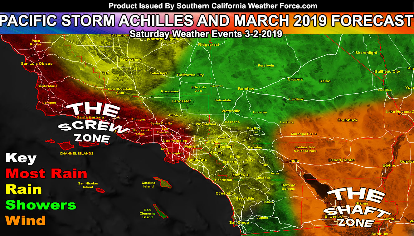
The first storm system hits on Saturday morning and it is Pacific Storm Achilles, a category two out of the 1-6 scale. In other words it really is not anything special. The system will have 30 mph wind gusts, 40+ at times in the mountain/desert regions, also Santa Barbara/SLO County. It will have a potent front that will weaken as it moves through OC/IE and especially before even nudging San Diego Proper. I have two alerts out for it … one for flash flood and one for flood advisory.
The SCWF Flash Flood Watch reads; A fast moving yet potent front will move through the region overnight tonight. The heaviest rainfall will start just after the 9pm hour for San Luis Obispo to Vandenberg, after midnight for Santa Barbara/Kern, and after 2am into sunrise for the Ventura/Los Angeles County areas. The SCWF Flood Risk Map has the region under a high risk for stream flooding due to everything happening in a short but potent time-frame. Residual showers are expected off and on through Saturday and Sunday, however after sunrise on Saturday the ‘heaviest’ flood producing cells would have moved out of the watch area. Another system comes in during the middle of this next week. This system will be watched as it will be more potent than this system, reintroducing the flood risk products once again.Most of the watch zone will see 0.50″ – 1.00″ of rainfall from this fast moving system.
The SCWF Flood Advisory reads; A fast moving yet potent front will move through the region early Saturday morning. The SCWF Flood Risk Map has the region under a moderate risk for stream flooding due to everything happening in a short but potent time-frame. Residual showers are expected off and on through Saturday and Sunday, however after noon on Saturday the ‘heaviest’ flood producing cells would have moved out of the advisory area. Another system comes in during the middle of this next week. This system will be watched as it will be more potent than this system, reintroducing the flood risk products once again.Everywhere in the advisory area could realistically see between 0.50 – 1.00″ of rainfall during the short period of time on Saturday morning. Because of how deep the moisture plume is, the Kern Deserts around Ridgecrest and Mojave will also see appreciable amounts of rainfall.
As always, stay tuned to Southern California Weather Force for further details. Look at the links below for help, including the ‘Optional’ link if you want to see the flood/rain risk maps on the main SCWF page. Everything is updated accordingly.
NOTE: The graphic above is for Saturday, 3-2-2019.. HOWEVER it can also be for the entire month of March for locations of the most rain I think will hit… which is LA westward due to an unfavorable ridge pattern ‘overall’ south of here.
OPTIONAL: Southern California Weather Force main page now has models, agendas, the alert map, and other things updated during storm events. You can bookmark the main site and check back during an event for the latest updates.
Click here to view the main page
EMAIL ALERTS: It pays for itself in one storm system. A very affordable e-mail alert system that only gives you SCWF weather alerts in YOUR micro-climate area.
Click here to join
MICRO-CLIMATE ALERT FACEBOOK GROUPS: Find yours today!
Click here to join
SOUTHERN CALIFORNIA ONLY: if it does not say “Liked” LIKE The Page Below and join thousands of informed weather forecast viewers in our region for more of the updates! noticeable
BEHIND THE SCENES FORECASTS/UPDATE PAGE: if it does not say “Liked” LIKE The Page Below and join thousands of informed weather forecast viewers in our region for more of the updates! noticeable