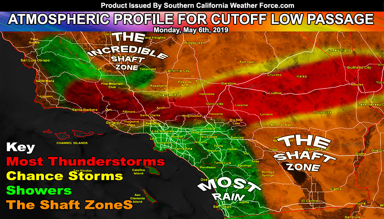
A cutoff low will enter Southern California overnight tonight and move through on your Monday and some of Monday night. The system will provide various zones with different weather from one another whether it be rain, shine, thunderstorms, wind, or of course that ever famous shaft zone where you get absolutely nothing fun at all so for your zone’s wording, read on for the details …
A Special Weather Statement is now in effect from this office for the following areas; Santa Barbara, Ventura, Los Angeles, and San Bernardino Mountains … LA Deserts … Metro High Desert … Ludlow to Needles Forecast Zones … excluding the Morongo Basin … Santa Clarita Valley … Ventura Basin/Coast … Santa Barbara Proper … The Cajon Pass Summit … and it reads; A compact cutoff low will drop into the region overnight tonight in the San Luis Obispo County areas. This, by Monday morning after sunrise, will bring some mid-level instability with it. Immediately near the center of this upper level low will be a small, but potent area of upper divergence and lift. This will start in Santa Barbara and Ventura County, mainly the mountains. The flow due to being so close to the center will make it likely these will travel southward on the west end of the upper level low into the metro basin and coastal zones of Santa Barbara proper and Ventura County. This will miss Vandenberg to the east so this statement is not for you.
Over the day this compact upper system will move eastward, bringing lift even across the Santa Clarita Valley zones, east still through the LA/SBD Mountain and Desert areas, including the Metro High Desert zones. It is likely that the entire Los Angeles County Mountain areas will light up with convection on your Monday with isolated activity near Big Bear. This system will continue to pop off and on thunderstorm activity through Ludlow to the Needles forecast zones overnight on Monday into Tuesday … exiting California by sunrise Tuesday morning. An upgraded alert is possible, however, this Special Weather Statement alert wording will do for now and will serve as the forecast for your Monday in those zones.
As for the rest of the forecast area. The Wind Advisory remains in effect for all desert zones, including the Imperial County areas, which will see nothing. So you may be considered in that ever so unlucky shaft-zone.
The metro Los Angeles, Orange, San Diego, and the Inland Empire areas will be under the zone for scattered off and on showers in popcorn fashion, meaning hit and miss. The best chances for better measurable precipitation through Monday will be San Diego County due to the westerly flow and mountain zones east of you providing the orographic lifting needed for the upslope activity to be ‘slightly’ heavier than most Orange, LA, and IE locations.
More shaft-zones are to be handed out and this may be the Kern Valley areas around Bakersfield. You neither are showing up as much precipitation or strong wind gusts so your fun has been sucked out the window if you like either.
A much larger and potent cutoff system will come in after your Wednesday and lasting through the weekend. This may hang around a bit so all eyes to the next event. As always stay tuned to Southern California Weather Force for official updates in your area …
OPTIONAL: Southern California Weather Force main page now has models, agendas, the alert map, and other things updated during storm events. You can bookmark the main site and check back during an event for the latest updates. Click here to view the main page
EMAIL ALERTS AND ASK THE WEATHER OFFICE A QUESTION: It pays for itself in one storm system. A very affordable e-mail alert system that only gives you SCWF weather alerts in YOUR micro-climate area. Also, you can ask the weather office a question at any time if you get that add-on. Click here to join
MICRO-CLIMATE ALERT FACEBOOK GROUPS: Find yours today! Click here to join
FACEBOOK PAGES TO JOIN!
SOUTHERN CALIFORNIA WEATHER FORCE MAIN: if it does not say “Liked” LIKE The Page Below and join thousands of informed weather forecast viewers in our region for more of the updates! noticeable
BEHIND THE SCENES FORECASTS/UPDATE PAGE: if it does not say “Liked” LIKE The Page Below and join thousands of informed weather forecast viewers in our region for more of the updates! noticeable