
CLICK HERE TO WATCH THE VIDEO BROADCAST FOR THIS ARTICLE
Alright welcome to Southern California Weather Force. First off I’ll dig into this weekend. As stated in the previous video/article, the weekend has a ridge building in ahead of a monsoonal flow. This ridge will push inland temperatures to over 100 degrees, seeing Riverside at 105 or higher given heat index from humidity as well. So yes, prepare for it to get hotter with the coming pattern.
NOTE: If you have renewed your discount membership for the 2019-2010 season, skip this message. If you have not, Click Here To Renew. This will be one of your last e-mailed article/alert from the 2018-2019 season as effective now the season will start on September 1st every year. Click Here To Renew Under The Discount.
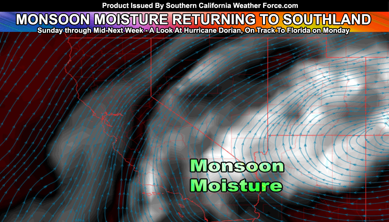
On Sunday, the monsoonal moisture will start to arrive into the low desert and San Bernardino, Riverside, and San Diego County Mountain areas. This should pop off some activity then as the start of the flow returning to Southern California. A very large complex of thunderstorms will form in mountain rim areas north and east of Phoenix, Arizona on Sunday, jetting west-southwest into that metro area and finally into our low deserts overnight and into early Monday morning.
How far west this will go will depend on how strong the initial outflow boundary will be but I can pretty much see it going as far west as San Diego County north to the Inland Empire and metro high desert zones through Monday. Quite often we get straggler fields of lift and moisture in the bight with such outflow boundaries to on Monday I wouldn’t be surprised to see something pop west of Los Angeles and the entire sky on Monday will certainly look and feel tropical.
Most of the activity will last through mid-week as impulses move through the area, each of their own carrying lift dynamics and moisture with them. After mid-week we will dry out the atmosphere once again as another trough comes in with a dry southwest flow.
After this, the main monsoon ridge will break down for good and we will have to rely on developing hurricanes south of here to get sucked up one by one and have their dynamics and moisture entrained northward into our region.
Speaking of Hurricanes, Hurricane Dorian will certainly hit Florida. There is no doubt about that. My general track has it hitting somewhere near Cape Canaveral or a bit south of there on Monday and then move up through Orlando and then curve on along the GA/SC coast and out to sea from there. Intensity is very hard to determine right now but it will be a strong hurricane when it approaches Florida. Given the trough to the north may actually slow it down for that northerly turn, the slow down may affect the western side of the storm and en-train some dry air into it before making landfall and weaken is some. Still, I do expect a Major Hurricane on Florida approach.
Well, my preliminary estimations are still that we will have a neutral season. That means neither El Nino or La Nina. Last season we had a Moderate El Nino. We should be sitting at neither and this does create very interesting scenarios that I am following. Season’s that typically were neutral had much better predictable storm events and some of these had low elevation snow at that. So this season in my preliminary does look like it will be a mixed bag of events from severe thunderstorms, lightning events, flooding, good mountain snow, and even low elevation snow events. Last season my forecast called for warmer and wetter than average. This was correct as we were above normal for rainfall and above normal in temperatures with that moderate El Nino. Given what I see, I may finalize this by October 15th or 25th with both a cold and warm season and a rainy one.
A volcano in Russia has erupted within the last week. This volcano has pushed a gas plume up to 70,000 FT. This type of pattern is what I said controls our weather patterns, not humans. SO2, or Sulfur Dioxide within the upper levels does reflect sun-rays back out into space and thus cooling things down and even altering the upper level jet stream.
Wind is the change in temperatures, and with that change in the Polar Jet Stream this next season, with the volcano being directly under it on the eruption now, we will see some very interesting patterns this Fall.
Starting with September. This next month will have what I call a shooting gallery effect. The shooting gallery effect is where our state of California has a trough to the west in the Pacific Ocean and a number of hurricanes come close to the region and the moisture and dynamics would get sucked into the region and provide the needed dynamics for shower and thunderstorm activity. I see this happening even as far north as Sacramento, Redding, Crescent City, and the San Francisco Bay area, in addition to our region of Southern California and east to Las Vegas and all of Arizona. It’ll be directly opposite of the month of August we have experienced, which usually has most of our monsoon activity. We are behind at least a month in nominal weather patterns.
As always, stay tuned to official forecasts from Southern California Weather Force for updates …
For The Main Weather Facebook Page Click Here and Join.
End Article
OPTIONAL: Southern California Weather Force main page now has models, agendas, the alert map, and other things updated during storm events. You can bookmark the main site and check back during an event for the latest updates.
Click here to view the main page
EMAIL ALERTS AND ASK THE WEATHER OFFICE A QUESTION: It pays for itself in one storm system. A very affordable e-mail alert system that only gives you SCWF weather alerts in YOUR micro-climate area. Also, you can ask the weather office a question at any time if you get that add-on.
Click here to join
MICRO-CLIMATE ALERT FACEBOOK GROUPS: Find yours today!
Click here to join
FACEBOOK PAGES TO JOIN!
SOUTHERN CALIFORNIA WEATHER FORCE MAIN: Southern California Weather Force Office Main Page
BEHIND THE SCENES FORECASTS/UPDATE PAGE: Southern California Weather Force Meteorologist Page
FOR THE CALIFORNIA FAULT STRESS MODEL PAGE: For SCWF official updates to the California Fault Stress Model and more!
“PONDER THIS” SCIENCE ADVENTURE SHOW: A science adventure show developed here at Southern California Weather Force that is a fun ride!
INSTAGRAM AND TWITTER ACCOUNTS TO JOIN!
Instagram – https://www.instagram.com/socalweatherforce/
Twitter – https://twitter.com/SCweatherforce