
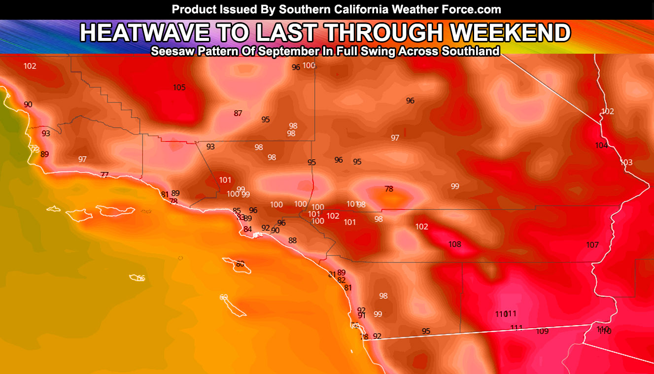
As projected in earlier updates here at Southern California Weather Force, the heat would return today through the weekend and so it has with near triple digit temperatures inland and it will be hotter over the weekend. Early this next week, a good trough moves in to knock the heat down. Projections here indicate that triple digit temperatures will hit most inland areas in the Los Angeles to Inland Empire areas over the weekend with 105-110F in the low desert zones, including the Colorado River Valley locations.
NOTE: If you have renewed your discount membership for the 2019-2010 season, skip this message. If you have not, Click Here To Renew. This will be one of your last e-mailed article/alert from the 2018-2019 season as effective now the season will start on September 1st every year. Click Here To Renew Under The Discount.
On Monday and Tuesday we will see the drop in temperatures as a dry cold front moves into the region. I would not be a bit surprised that overnight on Monday into Tuesday morning in the PMC/Gorman/Tehachapi zones, that some rain would fall with a strong northwest wind. This is similar to dry systems during our rainy seasons that pass to the north and if it is cold enough it would snow up there and nowhere else. However, this will not have snow with it as we have too high of a sun angle to produce any.
In addition to that, Monday and Tuesday will have the gusty winds in the mountain and desert areas. Would probably need wind advisories out once again for those areas.
As for the rest of the month. We remain in the see-saw pattern, which is quite normal for September here in Southern California. The see-saw pattern means that temperatures will skyrocket at times and then fall a few days later only to pick up again a few days after that. This is common because the jet stream is not too far south yet but is affecting the Northern California to Pacific Northwest zones with rainfall and leaving us on the dry end of it. However, every single time one of the troughs nears our area and we get a Hurricane to the south of here, it would pull it closer to us like it did Hurricane Juliette and the moisture would be entrained into the north flow into our region. Most likely period is after the 21st this month till the end of the month if the numbers hold.
Traveling to Western Oregon or Washington State? Without a doubt from tonight into the weekend to early next week will have numerous impulses move through and at times thunderstorms will hit. That area will get a good amount of rainfall during that period.
As always, stay tuned to official forecasts from Southern California Weather Force for updates …
For The Main Weather Facebook Page Click Here and Join.
End Article
OPTIONAL: Southern California Weather Force main page now has models, agendas, the alert map, and other things updated during storm events. You can bookmark the main site and check back during an event for the latest updates.
Click here to view the main page
EMAIL ALERTS AND ASK THE WEATHER OFFICE A QUESTION: It pays for itself in one storm system. A very affordable e-mail alert system that only gives you SCWF weather alerts in YOUR micro-climate area. Also, you can ask the weather office a question at any time if you get that add-on.
Click here to join
MICRO-CLIMATE ALERT FACEBOOK GROUPS: Find yours today!
Click here to join
FACEBOOK PAGES TO JOIN!
SOUTHERN CALIFORNIA WEATHER FORCE MAIN: Southern California Weather Force Office Main Page
BEHIND THE SCENES FORECASTS/UPDATE PAGE: Southern California Weather Force Meteorologist Page
FOR THE CALIFORNIA FAULT STRESS MODEL PAGE: For SCWF official updates to the California Fault Stress Model and more!
“PONDER THIS” SCIENCE ADVENTURE SHOW: A science adventure show developed here at Southern California Weather Force that is a fun ride!
INSTAGRAM AND TWITTER ACCOUNTS TO JOIN!
Instagram – https://www.instagram.com/socalweatherforce/
Twitter – https://twitter.com/SCweatherforce