
Carefully looking over the track of both Hurricane Lorena and Mario over the last 24 hours is leading me to go with the original forecast assessment of wrap-around into the Eastern forecast area, including all of Arizona by this next week. The cutoff low that will be responsible for the storm activity there has not been too consistent, but I did decide on the final path of it and that is into the Colorado River Valley, cutting off in Arizona. This cutoff will allow wrap-around moisture to make it through the Colorado River Valley, but NOT affect the metros south and west of the local mountains. Your turn is coming very soon.
NOTE: TIME IS RUNNING OUT. IF THIS TROUGH GETS A NAME THEN THE DISCOUNT WILL HAVE ENDED… If you have renewed your discounted MICRO-CLIMATE E-MAIL ALERT SYSTEM membership for the 2019-2020 season, skip this message. If you have not, Click Here To Renew. This will be one of your last e-mailed article/alert from the 2019-2020 season as effective now the season will start on September 1st every year. Click Here To Renew Under The Discount.
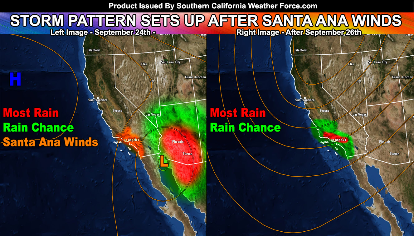
As this is making Arizona have storm activity with flooding as well, here in Southern California around Tuesday we will receive the back-side northeast flow and that means a Santa Ana Wind Pattern will show up. I will get the Santa Ana Wind alerts out in the next day if trends continue to go that way but you heard it here that they are pending.
Now, south and west of the mountains means Bakersfield, San Luis Obispo, Vandenberg, Ventura, Los Angeles, Orange County, San Diego, and the Inland Empire areas. A very large long wave trough will set over the West Coast of California after the 26th and this will bring in several impulses that will make it very likely that a good amount of rainfall for this time of year will hit. Of course troughs like this means a southwesterly flow so if we are talking about any mudslide debris flows we will see the heaviest rainfall in the Santa Barbara, Ventura, and Los Angeles County areas, with rain still for Orange/Inland Empire and the least in the San Diego/Vandenberg/San Luis Obispo/Kern areas. It is pretty typical for a southwest flow, however we are very early on in the season to even be seeing a trough like this so it is quite exciting from a scientific standpoint.
A mean average of my calculations says Ontario International Airport could see 0.75″ of rainfall before the month is over so even a bit less or a bit more is likely. It is safe to say that we will see our first metro rainfall south and west of the mountains before this month is over. This does bode well with my September forecast stating that after the 20th to end month will be our time to ‘shine’.
As always, stay tuned to official forecasts from Southern California Weather Force for updates …
For The Main Weather Facebook Page Click Here and Join.
End Article
OPTIONAL: Southern California Weather Force main page now has models, agendas, the alert map, and other things updated during storm events. You can bookmark the main site and check back during an event for the latest updates.
Click here to view the main page
EMAIL ALERTS AND ASK THE WEATHER OFFICE A QUESTION: It pays for itself in one storm system. A very affordable e-mail alert system that only gives you SCWF weather alerts in YOUR micro-climate area. Also, you can ask the weather office a question at any time if you get that add-on.
Click here to join
MICRO-CLIMATE ALERT FACEBOOK GROUPS: Find yours today!
Click here to join
FACEBOOK PAGES TO JOIN!
SOUTHERN CALIFORNIA WEATHER FORCE MAIN: Southern California Weather Force Office Main Page
BEHIND THE SCENES FORECASTS/UPDATE PAGE: Southern California Weather Force Meteorologist Page
FOR THE CALIFORNIA FAULT STRESS MODEL PAGE: For SCWF official updates to the California Fault Stress Model and more!
“PONDER THIS” SCIENCE ADVENTURE SHOW: A science adventure show developed here at Southern California Weather Force that is a fun ride!
INSTAGRAM AND TWITTER ACCOUNTS TO JOIN!
Instagram – https://www.instagram.com/socalweatherforce/
Twitter – https://twitter.com/SCweatherforce