
The Southern California Weather Force site will handle Arizona Weather Force linked articles until a main site can be developed for Arizona over the weekend. For now I’ll use that platform for the forecasts here. A system is expected to bring windy conditions statewide on Sunday, light snow for the central/north/east part of the state on Sunday evening and night, and a fire hazard for the Colorado River Valley on Monday. Read on for details …
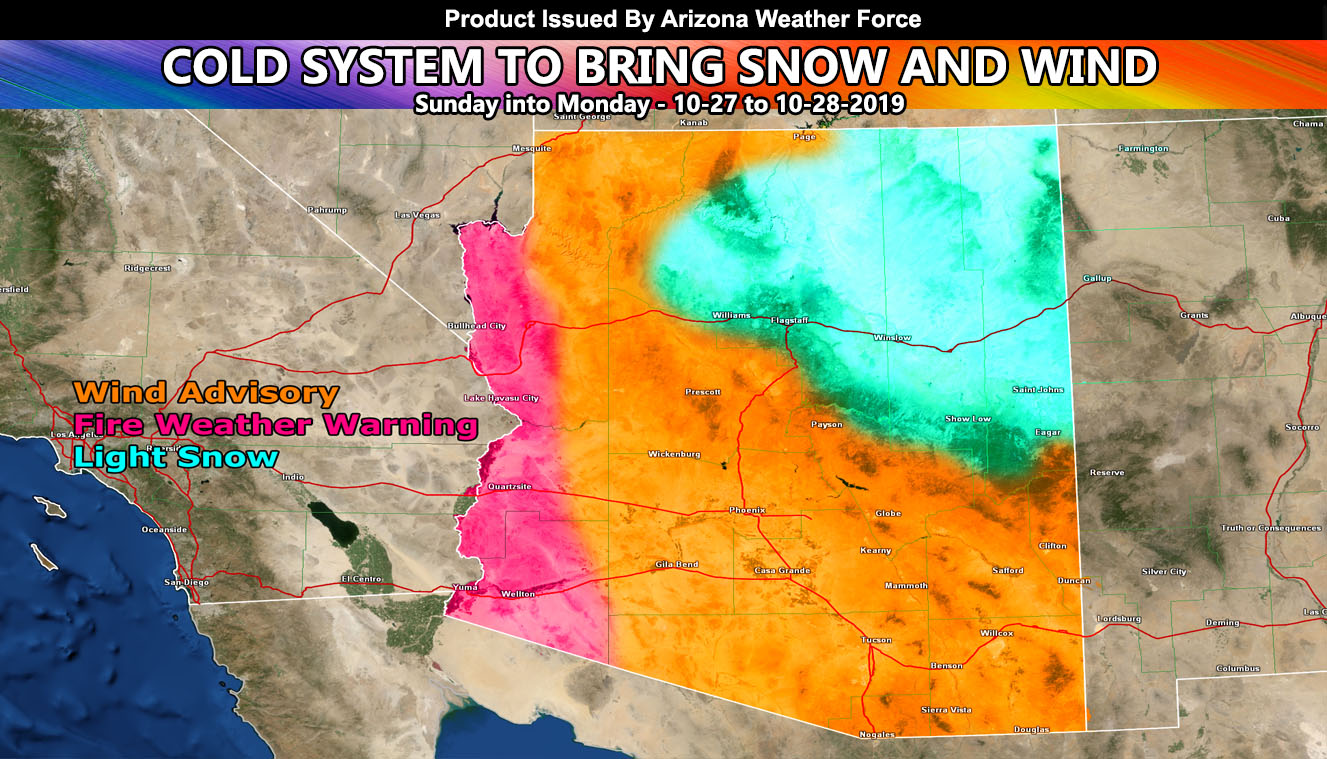
Wind gusts are in the area today as we finish off the Fire Weather Warning that was previously issued here at Arizona Weather Force for Thursday and Friday. We will have a break in the region on your Saturday before a trough of low pressure dips back down into the Rockies again for your Sunday. The low pressure north of the area will generate a southerly wind flow across the entire region, with wind gusts in Tucson near 40 mph and Phoenix around 30 mph. The Mogollon Rim, including Flagstaff, will see gusts over 50+ mph with this. Because of the southerly flow, humidity levels during this time and in these spots will be high enough to keep fire hazard alerts from being issued.
As Sunday evening rolls around, cold air from the lower sun will introduce precipitation across the Mogollon Rim, Flagstaff, parts of the Grand Canyon, and into the Colorado Plateau overnight into Monday morning as it exits into New Mexico. Snow accumulations are not expected to be a lot so consider this light snow and as so shaded on the forecast image.
At that same time, starting Sunday evening, winds will shift from onshore to offshore along the Colorado River Valley areas. Bullhead City will see gusts between 45 and 50 mph, with needles around 40-45 mph. These northerly winds will travel down the river and bring gusty winds over 30+ mph all the way through down to the Yuma forecast zones overnight and into Monday morning. Because of the low humidity conditions with it, I thought it would be prudent to issued a Fire Weather Warning with it.
The gusty winds will cease by evening and an additional system for returning winds will be monitored by mid-week. At this time I will stick to this system.
Arizona Weather Force Facebook Page For Updates – https://www.facebook.com/ArizonaWeatherForce/
Did you miss the 2019-2020 season forecast? – https://www.facebook.com/scweatherforce/videos/535421457025391/
Reading for another state? Find your region I serve here – https://www.facebook.com/nwfweather/photos/a.643550279121473/1544547759021716
About Page: Arizona Weather Force is derived from the work done at the largest weather forecast page for Southern California, Southern California Weather Force. Forecasts here are done by the same person so you can bet they will be accurate for you. This page will only operate during inclement weather concerns and went into operation on September 21, 2019. If you are ON the Colorado River Valley, Southern California Weather Force serves Needles, Blythe, Winterhaven/Yuma all the same …