
My strength is returning like kryptonite moving away from Superman and I’m almost to full power once again. I released the general outlook, which is your first-look at Pacific Storm Elvis on Saturday morning. The outlook stated something very important to you so you can keep an eye on my future forecast trends. It stated that just 24 hours ago the median calculation value for flood risk was 3.5 and now it is 2.5. Watching a decline like this over the next day or two will make me adjust some of these values no doubt. Furthermore I’ve seen yet another decline in my values over the last 24 hours after that article was released. That makes it a 48 hour decline, which does mean the storm is not the ‘storm’ of the century up in the mountains like I am hearing everywhere nor is it for us in the metros. This is the very reason I started him off as a category three out of six, which is a moderate storm system on the Southern California Weather Force Pacific Storm Scale.
Join Southern California Weather Force main Facebook Page for future updates!
One thing I always say is this … and I’ll say it again and again if I have to. I do not give two hoots and shoe box shiner violence what your pathetic apps on your phones say. I don’t care if they say rain or snow over a week out. Those are computers are may or may not change but I WILL NOT be pressured by them to do a forecast until I AM READY. I don’t care if I have to wait 3 days before an event and be last to say anything, Southern California Weather Force will only post with confidence when ready. Still, remember, just as the last system that went through I waited till 24 hours before and the day of for thunderstorm forecasts and I beat all the apps/sites etc. That is how it works here, you wait for my details as SCWF is the only place that has them when available.
So what does mean for the storm? Storm is on track to what I’ve been stating. There is a steady decrease in strength of both mountain snow and flooding in the area. While heavy rain and snow will hit at times, like I said … it isn’t historic, however it does happen during the Holiday travel so it will be important to know key areas. My winter alerts will go out over the day on Monday with better calculations and if needed so will the flood risks.
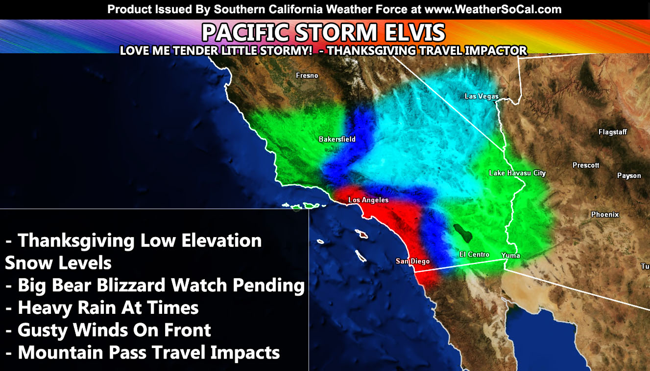
The first front will beginning across the San Luis Obispo / Vandenberg / Kern zones on Wednesday morning, early. It’ll affect the Ventura, Los Angeles zones over the morning then and finally into the High Desert, Inland Empire, OC, and San Diego County areas over the day and into the evening. This first front looks pretty quick moving through with the most rainfall from it where orographical lifting is higher across the Los Angeles Basin and surrounding zones. Snow levels with this will vary from mountain range on Wednesday, however the Gorman Pass will certainly see snowfall, possibly closing the pass, by mid-morning. Slightly warmer air advecting into the Los Angeles/San Bernardino Range will keep snow-levels starting around 6,500 FT so this is an all snow-front for Big Bear. The Cajon Pass will not see snow on Wednesday.
For your Thursday, the trough-base digs further south just west of Vandenberg AFB and this brings in even colder air into the region. Given what I see, Thanksgiving will have snow at the Cajon Pass so travelers be cautious or make other plans. Off and on showers and possible thunderstorms and hail will be likely. The snow-level on the pass and High Desert Metro regions will be around 2,700 FT. with non-sticking snow to 1,700 FT. Winter Weather Advisories will be needed for thus event for Thursday’s impulse if trends continue. This also includes areas in the higher elevations of the Las Vegas Central and West Valley. Thursday’s front also has deeper-moisture connections so the precipitation will make it into the Low Deserts where most of it will not on Wednesday and those of you in the RIV / SD Mountains will also finally see the snowfall from this system.
We aren’t done, first week of December still has values for the storm window remaining open so that is the next focus after Pacific Storm Elvis.
The micro-climate alerts with more details in those zones will go out over the alert system soon.
NOTE: ALL Articles AND Videos posted on Southern California Weather Force main Facebook Page are charity events. Anyone sharing will be entered into a list and one person will be randomly selected to get cash for causes. This started on in October 2019 and SCWF has donated $1883.24 to date of this article and counting. … So share away.. the more shares on Facebook, the more help can be done for the community and it costs you nothing just like a lottery ticket. October 2019’s winner was Jessica J Dominguez, and she has claimed the prize. Are you next? – Check the latest amount to win by CLICKING HERE – Remember… that number is going to climb before the contest closes!
MICRO-CLIMATE ALERT FACEBOOK GROUPS: Find yours today!
Click here to join
As always, stay tuned to official forecasts from Southern California Weather Force for updates …
For The Main Weather Facebook Page Click Here and Join.
End Article
FACEBOOK PAGES TO JOIN!
SOUTHERN CALIFORNIA WEATHER FORCE MAIN: Southern California Weather Force Office Main Page
BEHIND THE SCENES FORECASTS/UPDATE PAGE: Southern California Weather Force Meteorologist Page
FOR THE CALIFORNIA FAULT STRESS MODEL PAGE: For SCWF official updates to the California Fault Stress Model and more!
“PONDER THIS” SCIENCE ADVENTURE SHOW: A science adventure show developed here at Southern California Weather Force that is a fun ride!
INSTAGRAM AND TWITTER ACCOUNTS TO JOIN!
Instagram – https://www.instagram.com/socalweatherforce/
Twitter – https://twitter.com/SCweatherforce