
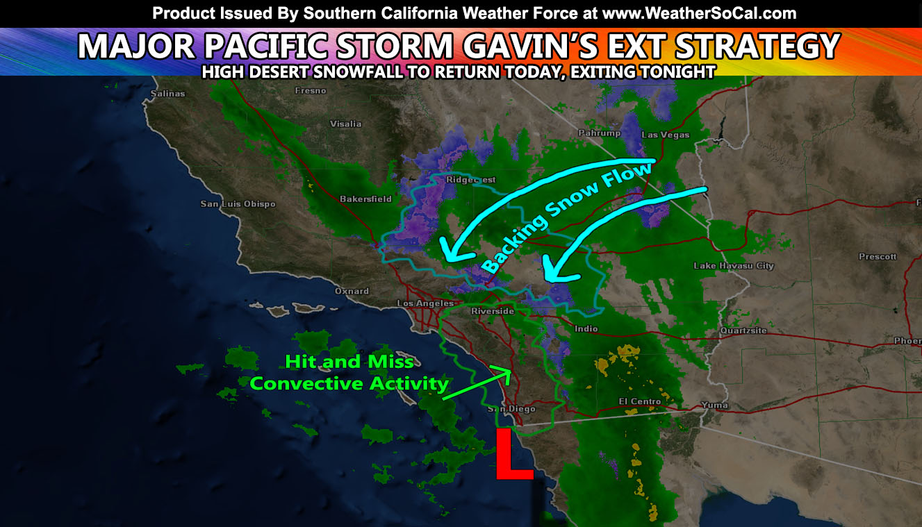
Major Pacific Storm GAVIN has brought category five out of six conditions on the Southern California Weather Force storm scale and is going as forecast thus far. There are reports and radar images I’ve gathered that tell me at least two tornadoes touched down, one in Santa Barbara County’s southeast coast and one in Ventura at the harbor. The storm isn’t over yet as the surface low backs moisture out of the north for metro high desert to see more snow so for the details read on …
Major Pacific Storm GAVIN (C5/2019) is placing itself in a position to start bringing the moisture back out of the north in what is called wrap around. With the cold/dry air in place in the High Desert that is when you will start to see the snow falling more later today. It will last till around 10-11pm and fade out as the storm pulls away through Arizona. So do not worry, you’ll get some snow in the metro High Desert and AV regions, this system was never meant to bring you snow along the initial front. I expect the snow to stop up up at Gorman by 8-9pm tonight and the Cajon Pass somewhere just after midnight with Big Bear proper holding on till at least 5am on Friday.
Hit and miss convective activity still expected today for the OC, San Diego, and IE locations. Santa Barbara and Ventura proper you are done with this system.
Offshore weak Santa Ana Winds will develop for the mountain pass regions and some of the SCV locations later today and last through some of Friday… dying over the day on Friday.
All Squall-Line Watches (Click Here) and even the Flood Advisory (Click Here) in the Imperial Valley area worked perfectly. So far the storm is on track to the forecast.
Another cold system is expected in the area on the 30th through 31st. This is a cutoff and details on this are fickle but I think it will be more inland.. still affecting us though so don’t get me wrong. I will be monitoring that one over the next day and will bring you details as I calculate them.
As for what happened thus far. I issued a Tornado Watch just before noon on Christmas for Christmas evening through after midnight this morning. The SCWF Tornado Watch targeted Santa Barbara and Ventura County, as far east as Malibu. Last night we had a large rotation signature detected near the Channel Islands. I continued to monitor it until I issued a Tornado Warning polygon to the micro-climate groups (Find your by clicking here) and it was an hour lead-time before NOAA issued theirs. In the image below you can note the upper left is the official SCWF Tornado Watch with model (Click Here) And the lower left was an hour before NOAA’s ‘warning’ as it was developing near the Channel Islands …
Believe it or not, the tornado warning alert I issued for the image below went out via my notification app. It’s worth every penny to subscribe on the monthly basis to that. (Click Here To See The App Links). SCWFweather is not a normal app. It is an app that is custom made to notify you and link you to the proper micro-climate alerts in the zones you choose.. and there are a lot of zones. It might save your life one day as I know it as many others.
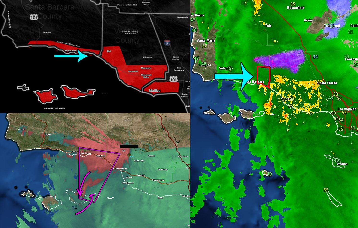
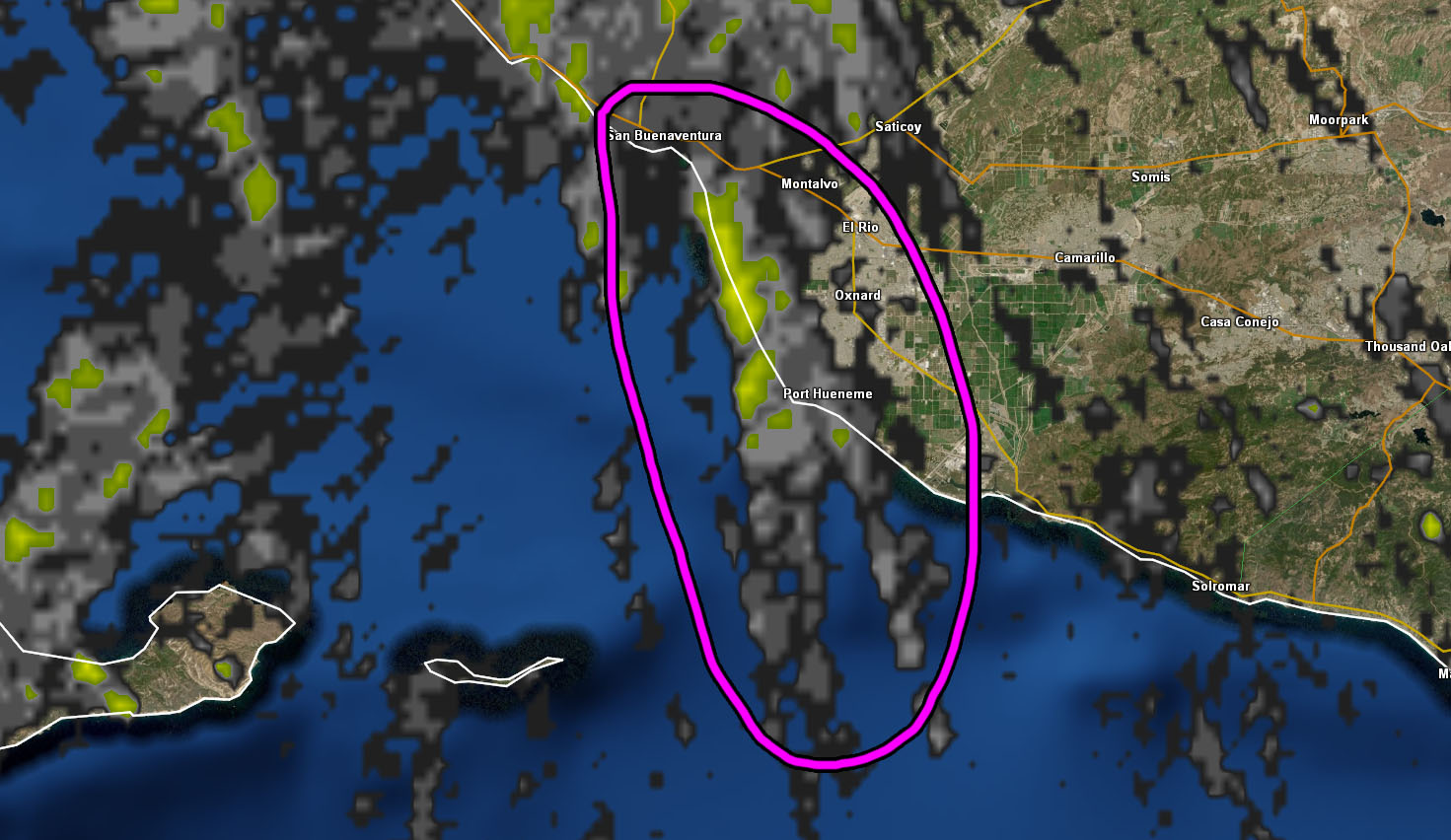
The Ventura County Fire Department stated that trees were uprooted at the Harbor with some damage. Going back I can clearly see that a very quick forming waterspout did move over there. The image below shows the track from south-southeast to north-northeast over the harbor. This will mean that two tornadoes were likely in the region and both where within my Tornado Watch, giving more than a 10 hour lead-time due to my new tornado forecast model, a true milestone.
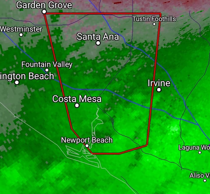
Now after midnight is where the kicker is. A Tornado Warning was issued by NOAA for Orange County. Are you seeing the above images? Do you see anywhere near the tight circulation of reds and greens touching? There’s nothing in the image to show it. I am willing to bet it was an intern that has no idea what they are doing. I saw no dynamics nor need for that to go out. So not only do I have to take over the ‘job’ of the people at NOAA, I have to babysit their botched tornado warnings as well? ugg… The image is here.
NOTE: ALL Articles AND Videos posted on Southern California Weather Force main Facebook Page are charity events. Anyone sharing will be entered into a list and one person will be randomly selected to get cash for causes. This started on in October 2019 and SCWF has donated $1883.24 to date of this article and counting. … So share away.. the more shares on Facebook, the more help can be done for the community and it costs you nothing just like a lottery ticket. October 2019’s winner was Jessica J Dominguez, and she has claimed the prize. Are you next? – Check the latest amount to win by CLICKING HERE – Remember… that number is going to climb before the contest closes!
MICRO-CLIMATE ALERT FACEBOOK GROUPS: Find yours today!
Click here to join
As always, stay tuned to official forecasts from Southern California Weather Force for updates …
For The Main Weather Facebook Page Click Here and Join.
End Article
FACEBOOK PAGES TO JOIN!
SOUTHERN CALIFORNIA WEATHER FORCE MAIN: Southern California Weather Force Office Main Page
BEHIND THE SCENES FORECASTS/UPDATE PAGE: Southern California Weather Force Meteorologist Page
FOR THE CALIFORNIA FAULT STRESS MODEL PAGE: For SCWF official updates to the California Fault Stress Model and more!
“PONDER THIS” SCIENCE ADVENTURE SHOW: A science adventure show developed here at Southern California Weather Force that is a fun ride!
INSTAGRAM AND TWITTER ACCOUNTS TO JOIN!
Instagram – https://www.instagram.com/socalweatherforce/
Twitter – https://twitter.com/SCweatherforce