
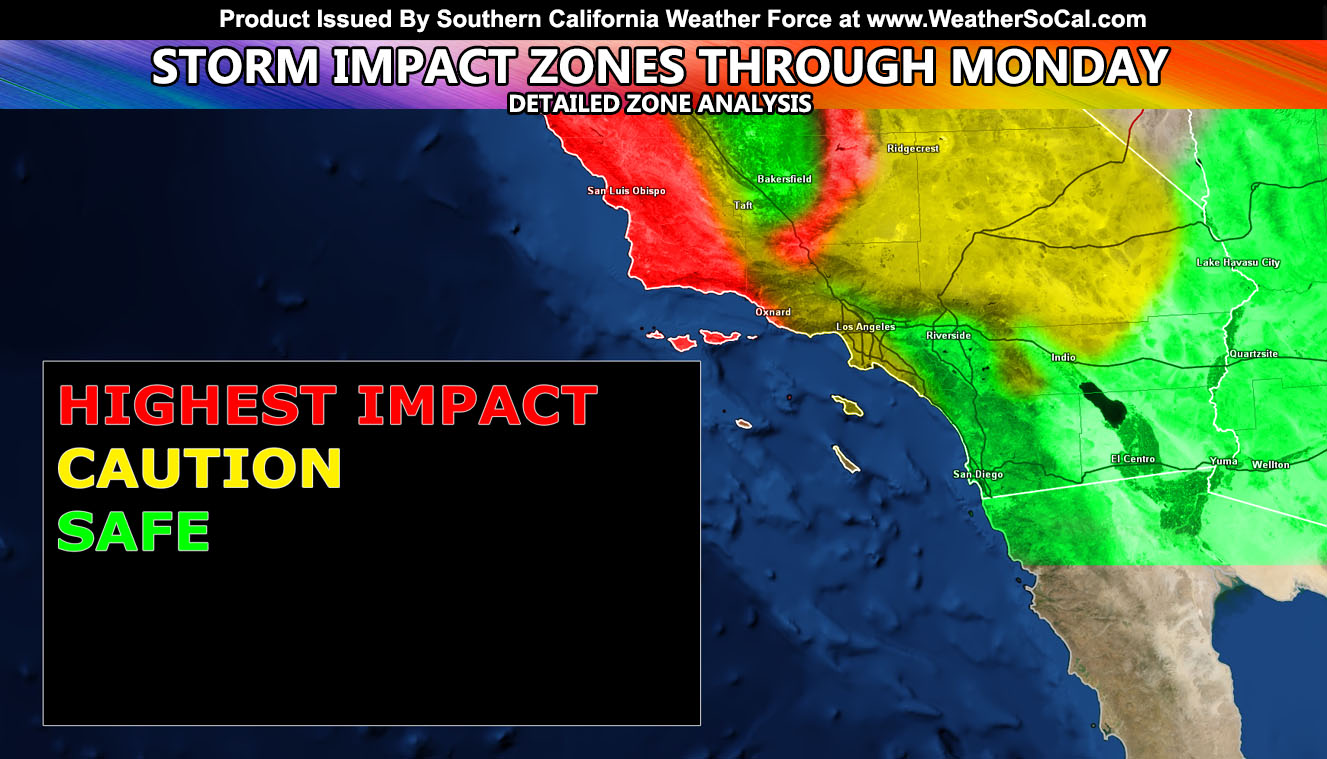
Pacific Storm Hercules is going to act like a normal cutoff low and kind of veer off track due to the detachment from the jet stream and forecast changes have to be made. This is my Stoplight Forecast, which means I will deliver a detailed view of what the system is likely going to do based on what I see 36-48 hours out and only done via cutoff lows. Read on to find your area, and yes I mean read this not just the image because this article has details.
Join Southern California Weather Force main Facebook Page for future updates!
MICRO-CLIMATE ALERT FACEBOOK GROUPS: Find yours today!
Click here to join
The storm system is already a headache, but since it will impact the red-zones, meaning Ventura westward to San Luis Obispo and Santa Barbara County, it will remain as a category three. Just like a hurricane, the track of the main dynamics misses parts of the forecast area and this is what will happen there. So the red-light means you will see the MAIN IMPACT from the system. Ventura, any further west and you are out. Confidence is high that Santa Barbara and San Luis Obispo will have the main impacts from this system.
It is a cutoff and I am allowed changes up to 24 hours before it hits in my scientific point of view. If I see the track veer I will say it and will not say rain to appease people. Expect barely a thing if LA/OC/IE/SD… People in the green can go about their travels. People in the yellow remain caution to the original forecast, and the people in red your day will be ruined with the highest impacts.
Caution Light – The caution, or monitoring light, is what I use when the forecast is still in question and has enough pull to maintain. Now… My winter weather watches in the High Desert and Morongo Basin did not say snowfall on heavy accumulations. This would have been a Winter Storm Watch, not Winter Weather Watch. So ANY amount of snow, whether it be flurries… would match up with this. The monitoring will continue and finalize on Sunday afternoon for you in the High Desert and Morongo Basin, including the Los Angeles, San Bernardino, and Riverside County Mountains.
As the storm system sags southward, this will pull a northeast flow into it and we very well could still have snow in the High Desert and the mountain areas surrounding it, including Big Bear/Wrightwood etc. This sagging southward of the system will pull dry air off the mountains and this is why I think the metro Los Angeles/OC/IE areas, while it may rain a bit … you will be experiencing drier conditions along with gusty offshore winds at the same time the High Desert and neighboring mountains have some snowfall chances.
This entire system is going to have a mix and match of dynamics. You can be in the Santa Clarita Valley on Monday with 40 mph wind gusts in Santa Ana Wind fashion, passing showers while it is pouring in Santa Barbara, snowing in some high desert locations, and dry in the Imperial Valley.
The Rain: Rain impacts will be further west of Los Angeles in the Western VT, all of SBA/SLO County areas. This is where I will keep the heaviest rainfall impacts. Because of the gusty offshore Santa Ana Winds on Monday, I am thinking it will be a day of light scattered showers anywhere south and west of the mountains, including the Kern Valley areas. The only place that will not get anything, in what I call ‘The Screw Zone’ will be the Imperial Valley. Unlike the last system, and what I said previously, you have zero chance at anything.
For Snow: This type of pattern favors the Northeast side of the mountains of Los Angeles, San Bernardino, and Riverside. This means that Crestline is spared with only a dusting, Big Bear will be dumped on in town and on the east end while the dam is a dusting, Palm Springs Tram dumped on while Idyllwild has way less on the shadow side of this event, Wrightwood hit with snow, possible a good amount if this flow hits right, Cajon Pass affected with 2-4″?, Gorman near 0-2″, a dusting in the foothills south/west of Lancaster, nothing in the Antelope Valley, a dusting in Metro High Desert (Victor Valley areas), good amounts in the Yucca Valley/Landers areas, 0-2″ in Tehachapi, 2-6″ in PMC while Frazier Park’s placement has more.
VEGAS TRAVELS: This system still has a caution flag up for Monday. Snowfall on I-15 and I-40 is still being cautioned and monitored, including the Cajon Pass.
I think that is about where I’m going with this. Dynamics will vary by location with this storm and if you are in the green zone you are safe, yellow zone remain to the alert system and/or FB page for updates, and the red-zone you are in the highest risk zone for the largest impacts from this system.
Stay tuned to Southern California Weather Force for additional alerts and information.
MICRO-CLIMATE ALERT FACEBOOK GROUPS: Find yours today!
Click here to join
As always, stay tuned to official forecasts from Southern California Weather Force for updates …
For The Main Weather Facebook Page Click Here and Join.
End Article
FACEBOOK PAGES TO JOIN!
SOUTHERN CALIFORNIA WEATHER FORCE MAIN: Southern California Weather Force Office Main Page
BEHIND THE SCENES FORECASTS/UPDATE PAGE: Southern California Weather Force Meteorologist Page
FOR THE CALIFORNIA FAULT STRESS MODEL PAGE: For SCWF official updates to the California Fault Stress Model and more!
“PONDER THIS” SCIENCE ADVENTURE SHOW: A science adventure show developed here at Southern California Weather Force that is a fun ride!
INSTAGRAM AND TWITTER ACCOUNTS TO JOIN!
Instagram – https://www.instagram.com/socalweatherforce/
Twitter – https://twitter.com/SCweatherforce