
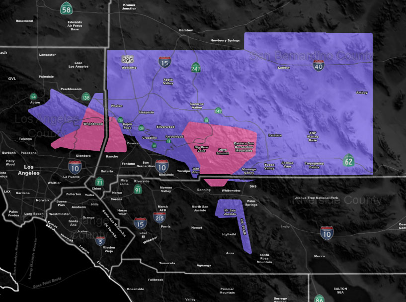
Issued Zones: Metro High Desert (Victor and Lucerne Valley) … Morongo Basin … Wrightwood … San Bernardino County Mountains …Riverside Mountains (Tramway) …
Site: Southern California Weather Force has issued a Winter Weather Advisory embedded Winter Storm Warning effective Monday morning through Tuesday Morning …
Date: 12/29/19 at 1:00pm PT
Forecast: A strong pacific system will miss the forecast area well to the southwest. However, the width of the system is going to be the kicker here and the upper divergent section of the storm (lift) will be over the San Bernardino Desert around Ludlow by Monday morning. This will bring a backing northeast flow into the system and with the moisture in place, it’ll squeeze every bit of moisture it has once the orographic lifting hits the north/northeast/east side of the LA/SBD/RIV Mountain ranges. This is where the snowfall forecast is coming in and why.
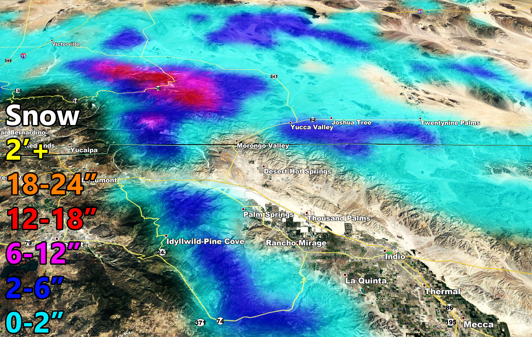
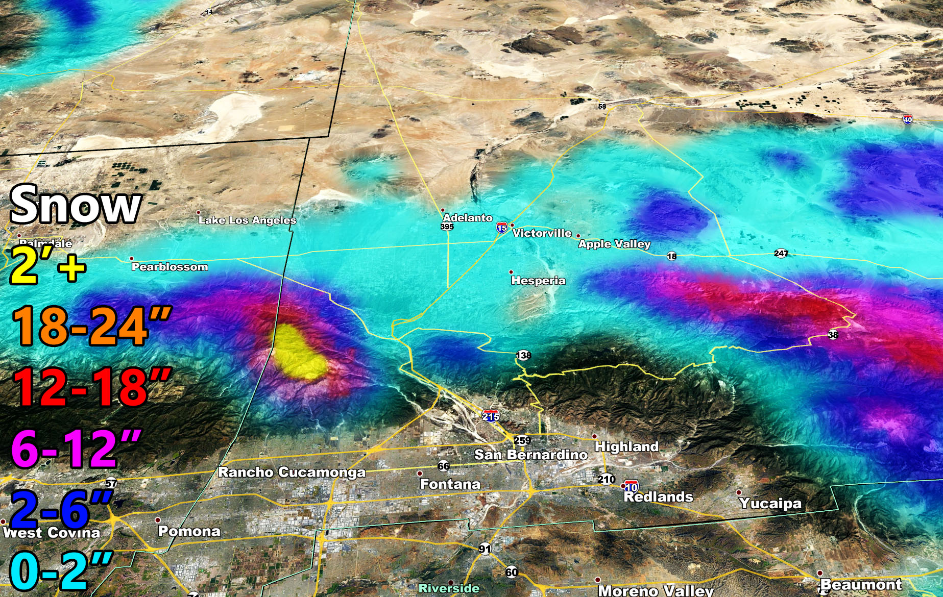
Now for areas … The SCWF Winter Storm Warning is for the prolonged period of snow from Monday morning through Tuesday morning. This could be an 18 hour snowfall and even if gentle at times… the high snowfall ratios due to the drier air mixing in.. will make snowfall pile up. For the Wrightwood areas you will see a suitable amount of snowfall, maps are provided. Big Bear you will see a good amount in town and the eastern end of the mountain/city while the dam (west end) sees a dusting. Again this is going to show what SCWF models are capable of in a short distance on the mountains.
The Winter Weather Advisory is for ANY falling snowfall and this is for the Metro High Desert, including the Cajon Pass to Morongo Basin and even Crestline for any leakage over the mountain. Yucca Valley will see the most from the advisory area. The east end of the Riverside Mountains will catch the moisture and thus a good 2-6″ is possible in the Palm Springs Aerial Tramway area.
BIG BEAR TRAVEL PLANS. If you are traveling to and from Big Bear, take the 18. Do not attempt the 38 into the SCWF Winter Storm Warning zone where snow will be the heaviest on the Eastern Range. Those traveling up from the High Desert, do not attempt Lucerne to Big Bear on Highway 18. Take Silverwood through to the 18 and go around that way.
CAJON PASS: I do not see a reason to close the pass with this system. To and from Vegas be cautious in the 0-2″ area but overall not a big deal.
Forecast amounts could go a bit lower or so but the general idea is in this alert write-up on where the snow will catch and where it will not.
How to get these alerts with a premium subscription? (100 percent delivery time)
Click Here For Options
Join A Micro-Climate Group On Facebook For These Alerts? (50 percent delivery time)
Click Here To Find Your Location Served By SCWF Today!
NOTE: If you read this from a SCWF micro-climate Facebook Group, keep in mind that forecast ARTICLES are NOT posted there unless it directly affects you. You will want to go to the MAIN SCWF Facebook Page and to go there you CLICK HERE.
10 mile rule: These alerts issued on this site means that within your zone and 10 miles from you will see the event forecast for. You may or may not see the event but it means you are in the zone or 10 miles from where someone will.
Forecaster: KM