
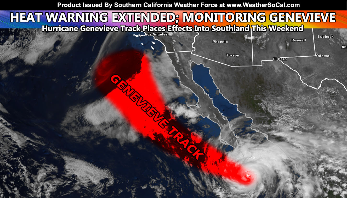
Southern California Weather Force has officially extended your high heat warnings till Friday evening, and then the focus is the weekend as Hurricane Genevieve positions for an upswing of shower/thunderstorm activity yet again over the weekend so read on for details.
This morning at around 8am I issued the Severe Thunderstorm and Thunderstorm Watch alerts over the member micro-climate e-mail alert system and the micro-climate Facebook groups which you can find in links below. Storms have already formed in the JTNP, Big Bear, Wrightwood, and Anza areas as I type this and the watches look on track to send outflow up through the High Desert as far as Ridgecrest and Las Vegas. You can view the links below to them.
Severe Thunderstorm Watch
Zones: San Diego, RIverside, San Bernardino, Los Angeles Mountains … Metro High Desert and Morongo Basin …
Link – https://www.southerncaliforniaweatherforce.com/2020/08/19/severe-thunderstorm-watch-34/
Thunderstorm Watch
Zones:: LA Deserts … Kern Desert … Kern Mountains Lake Isabella but NOT Tehachapi … High Desert … Las Vegas Metro … Hemet Valley …
Link – https://www.southerncaliforniaweatherforce.com/2020/08/19/thunderstorm-watch-85/
As for the rest of the week, I’ve extended the high heat warnings through Friday evening. After that we should get rid of the high heat 100s in the inland areas, but it will still be hot. We will then add humidity to that and you will have pretty much an uncomfortable weekend as Hurricane Genevieve nears the region. The moisture from Genevieve will stream northward and give the entire forecast area a chance at showers or thunderstorms, including the coast/valley areas. Since it has mid-level instability in the metros overnight on Saturday, storm chances will go into the night hours as well for metro areas. These will be dry-lightning producers with little rain so fire risk is elevated.
As for the extended towards the end of my month, my birthday, still seeing above average temperatures returning with the tropics also getting more active.
As always, stay tuned to Southern California Weather Force for official forecasts and updates in weather across Southern California
Join Southern California Weather Force main Facebook Page for future updates!
MICRO-CLIMATE ALERT FACEBOOK GROUPS: Find yours today!
Click here to join
Reading for another state? Join my national page – https://www.facebook.com/nwfweather/
All articles and micro-climate alerts can be delivered to you via the email alert service subscription and we are on a FREE TRIAL ALL SUMMER so CLICK HERE to join
MICRO-CLIMATE ALERT FACEBOOK GROUPS: Find yours today!
Click here to join
As always, stay tuned to official forecasts from Southern California Weather Force for updates …
For The Main Weather Facebook Page Click Here and Join.
End Article
FACEBOOK PAGES TO JOIN!
SOUTHERN CALIFORNIA WEATHER FORCE MAIN: Southern California Weather Force Office Main Page
BEHIND THE SCENES FORECASTS/UPDATE PAGE: Southern California Weather Force Meteorologist Page
FOR THE CALIFORNIA FAULT STRESS MODEL PAGE: For SCWF official updates to the California Fault Stress Model and more!
“PONDER THIS” SCIENCE ADVENTURE SHOW: A science adventure show developed here at Southern California Weather Force that is a fun ride!
INSTAGRAM AND TWITTER ACCOUNTS TO JOIN!
Instagram – https://www.instagram.com/socalweatherforce/
Twitter – https://twitter.com/SCweatherforce