
Article Contents: Cutoff low rounding Southern California with effects projected after the 21st. The El Dorado Fire Landslide Assessment Risk zones have been released so read on for details …
Join Southern California Weather Force main Facebook Page for future updates!
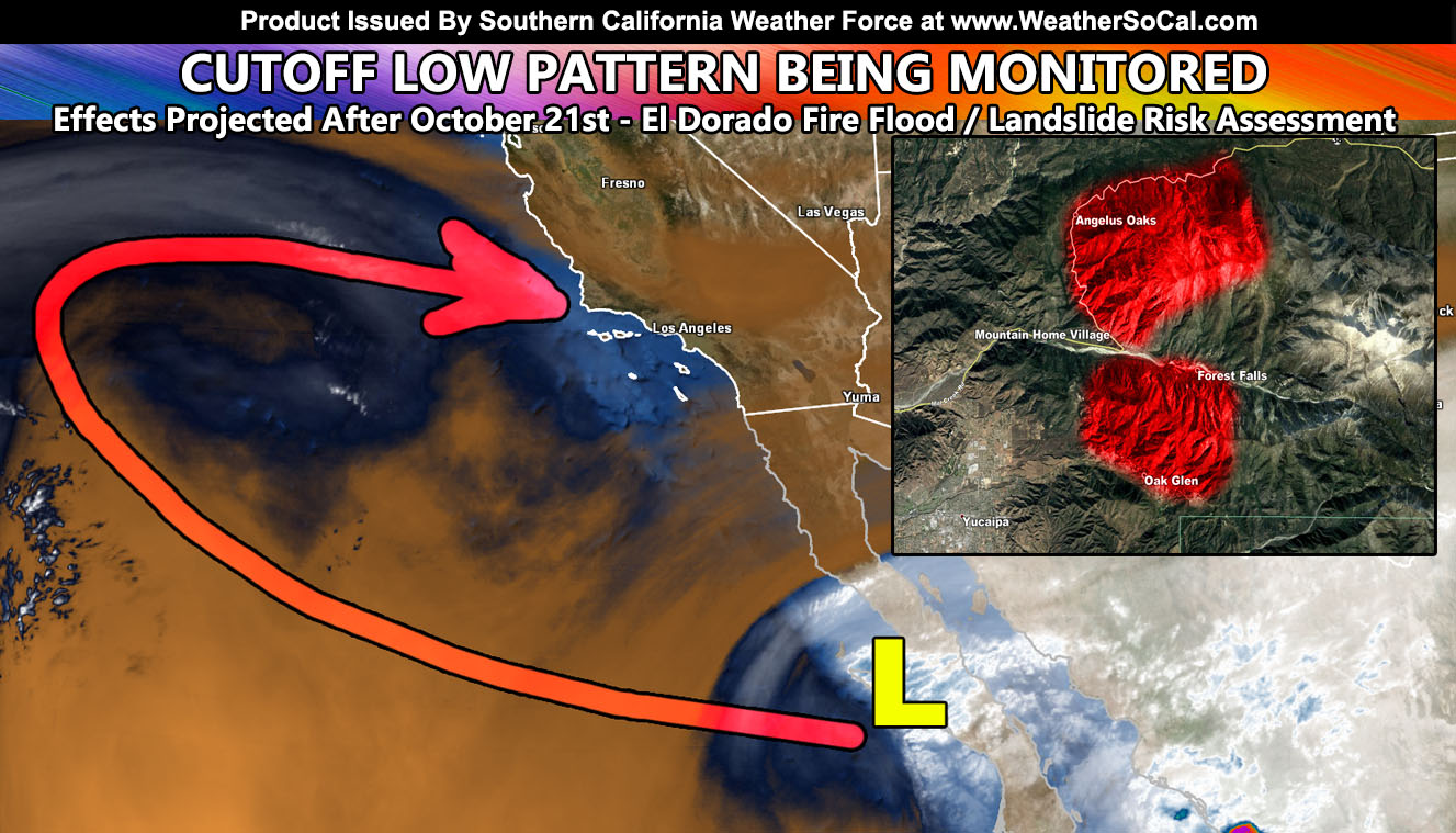
A cutoff low spoken about in the previous article has detached and is south of us, rounding Southern California this week and making a run for us against around or after the 21st. In the last article (Click here) it was mentioned that the cooler temperatures we had over this past weekend was attributed to a cutoff low moving over the region. The “?” was where to after that. It was sinking far enough south to warrant the chance it detaches from the original trough base and meanders south of here, possibly having a future impact later on in the period. This looks to have been the scenario, but the effects are still unknown, it after is … a cutoff low and we are still a week away.
This cutoff is projected to move westward and then north, back into the main west to east flow around the 19th or 20th. From there, it can move into our region and whatever moisture it has can be brought here. It isn’t a lot moisture so don’t be thinking this is a big storm. The upper system may actually drag a slightly stronger upper level system in a few days after it passes us. We are in what is called cutoff low season so anything is possible with them. I will continue to monitor them and bring you the latest as both confidence and studies permit.
As for the El Dorado Fire landslide risk assessment. The El Dorado Fire happened in what is known as Southern California’s catcher’s mit for rainfall. This means that mostly southwest to northwest low level flowing jet dynamics meet at that zone with our most powerful systems. You can easily see 4″ of rain there while Riverside has 1″ or less in many storm situations due to the topography. In surveying the area over the last weekend, The entire ridge area south of Forest Falls and north of Oak Glen is completely burned, only naked trees remain. The amount of ash there is enough to warrant the risk of a lahar in both cities this season, including a landslide. A lahar is usually a volcanic term, but I have used it in the most serious situations such as Montecito’s lahar that caused destruction, wiping out highway 101, and killing a number of people. It is mud, debris, and ash flowing down the slopes and into the valleys from there. This is all going to happen this year, putting both cities at risk if a major storm hits. Remember, just because it is a La Nina and below average rainfall may be projected does not mean the danger is not there. Montecito happened during a low end rainy season. Hurricane Andrew was a category 5 in South Florida in 1992 and happened during one of the lowest hurricane seasons on record. It only takes one.
Furthermore, the assessment we as far as Angelus Oaks. The slopes east of there and south of Highway 38 have the same risk as Oak Glen and Forest Falls. A landslide risk taking out Highway 38 is in the cards this year. Here at Southern California Weather Force I will be issuing flood risk maps, rainfall amount forecasts, and watches/warning … so you will know when not to travel these areas due to the risk assessment I have done.
A risk assessment is being made shortly for the Bobcat Fire zones. My pre-risk assessment calls on Highway 2 as the danger spot to travel during flood warnings that I issue in future storms. Always keep up to date to my warning alert system.
Facebook changed their algorithm and I put a video out explaining how you can see the posts from me at the top of your news-feed and that can be viewed by CLICKING HERE
Did you know? I now have a page for a lot of science stories, including some funny/interesting/weird stuff as well? Stuff you would be interested in like Astronomy, Solar Flares, Volcanoes, Earthquakes, and more! CLICK HERE AND FOLLOW/LIKE/JOIN/INTERACT WITH NEWS REPORT BANDIT TODAY!
As always, stay tuned to Southern California Weather Force for official forecasts and updates in weather across Southern California
Join Southern California Weather Force main Facebook Page for future updates!
MICRO-CLIMATE ALERT FACEBOOK GROUPS: Find yours today!
Click here to join
Reading for another state? Join my national page – https://www.facebook.com/nwfweather/
FACEBOOK PAGES TO JOIN!
SOUTHERN CALIFORNIA WEATHER FORCE MAIN: Southern California Weather Force Office Main Page
NEWS REPORT BANDIT: Tired of Politics and Celebrities and want funny, interesting, weird stories, including science like solar storm, earthquake, volcano, space stories updated 1-2 times a day?
FOR THE CALIFORNIA FAULT STRESS MODEL PAGE: For SCWF official updates to the California Fault Stress Model and more!
PROJECT DESTINI WORLDWIDE QUAKE PREDICTION – A system that shows worldwide plate stress due to numerous factors
INSTAGRAM, TWITTER, and NOW TIKTOK SHORTS ACCOUNTS TO JOIN!
Instagram – https://www.instagram.com/socalweatherforce/
Twitter – https://twitter.com/SCweatherforce
Tiktok – https://www.tiktok.com/@nationalweatherforce