
A setup I’ve been watching since before October 13th is finally upon us and the cutoff low west of Southern California will be a major player in dragging an arctic low pressure center down across the state Sunday into Monday, which will bring various weather conditions depending where your zone is. I’ve issued five alerts across the state today in response in the best thing I can see on how this will act so read on for details.. and also use the click here links if your area is mentioned.
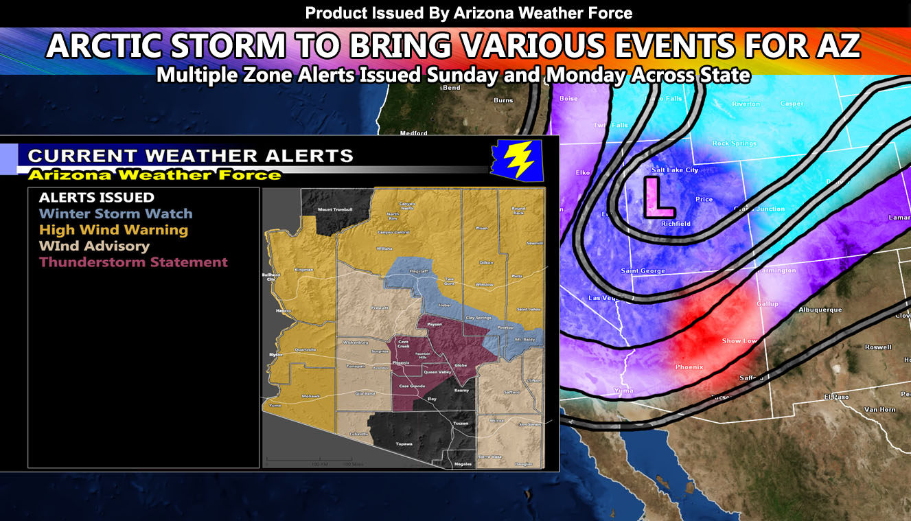
Five alerts went out this morning. The first alert that went out was the Winter Storm Watch. Given the track of the storm will be directly over the state on Monday, this affects locations in Northern and Eastern Arizona, the Rim areas. High winds will also accompany it on Sunday, but not on Monday with the snow falling, so I did not feel a need for a Blowing Snow Advisory or anything like that. So if you’re in Flagstaff, expect wind on Sunday with the High Wind Warning (Click here) and the Winter Storm Watch separate for Monday (Click here). The wind intensity chart is in the alert ‘Click Me’ wording in this article paragraph.
The next alert I issued over the micro-climate email alert premium member system was the High Wind Warning + Wind Advisory (Click Here) for Sunday night into mainly Monday for the Western half of Arizona, into parts of Southeast state. The wind intensity chart is in the alert ‘Click Me’ wording in this article paragraph.
The last one I issued was a Thunderstorm Statement. This statement is for parts of Maricopa, Pinal, and Gila County and you can view the shaded alert zones by Clicking Here. The image in this article on Sunday into Sunday night through to Monday morning in spots shows the location (red-shade on the map) that I calculated the dynamics to warrant thunderstorm wording. Additional alerts will go out so if you are in the micro-climate alert system, you’ll get them e-mail delivered. Everyone else reads from the Facebook articles like you are now whenever they are posted, sometimes hours after alerts go out because I only post at 11:30am or in the later afternoon/evening hours. If you wish to join the email alert service, the link info is below. If you joined in the Summer and did not renew, it expires in a week.
It all depends on the center of this low. If the center goes directly into Central Arizona then this forecast will be perfect. If it goes west of Arizona, more areas will see thunderstorms than just the tiny area I have shaded. For now, I am keeping it right over the state, which effectively takes Southern California out of good storm chances as well. One thing I am confident on is that this system points Phoenix north and eastward with the best storm chances and updates will come.
Stay tuned to official forecasts here at Arizona Weather Force
As you know, just as Southern California Weather Force has a service for members with micro-climate alerts, Arizona Weather Force does as well and we do have some people already signed up getting those so it is seeming like it is helping. The service helps businesses and persons, especially with ranches. Click Here to read about it and even join.
NOTE: This is the SCWF Website but it is being used for national updates until ad placement is ready on the AZWF site.
Your Facebook Page to join for this update is linked here – https://www.facebook.com/ArizonaWeatherForce