
Issued Zones: Los Angeles and San Bernardino Mountains, including Acton and the Cajon Pass … Morongo Valley to Yucca Valley … JTNP … CO/RIV Deserts at the border … Western Inland Empire from Ontario to Corona/Riverside … Santa Ana Mountains … Central OC to Newport Beach … Santa Clarita Valley … Ventura Basin/Coast …
Site: Southern California Weather Force has issued a Santa Ana Wind Watch effective now for Monday …
Date: 10/23/20 at 10:30am PT
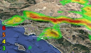
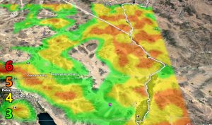
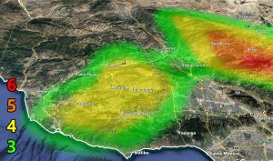
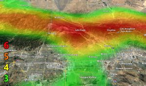
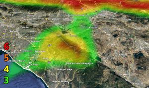
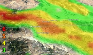
Forecast: An arctic system moving across the Great Basin and into Arizona on Monday will generate strong northerly winds, the strongest Santa Ana Wind Event of this season. The wind models below, custom designed, shows the magnitude of the event, with intensity 6 hitting the Cajon Pass as well.
Use the 6 images below in various parts of the watch area to determine your intensity on Monday. The winds are noted of having a mountain wave profile on the models seeing the higher intensity lines extending from the LA to San Bernardino Mountains …
6. SOME Trees are broken or uprooted, building damage is possible. – High Profile Vehicle Roll-Over Likely, Do NOT recommend Traveling in this zone
5. Slight damage occurs to buildings, shingles are blown off of roofs. HIGH WIND WARNING CRITERIA – High Profile Vehicle Roll-Over Possible if weight is not corrected.
4. Twigs and small branches are broken from trees, walking is difficult. Anything 4 and above will have blowing dust if conditions are dry, which does reduce visibility and make driving difficult …
3. Large trees sway, becoming difficult to walk. POWER SHUTDOWN THRESHOLD during any high fire risk. WIND ADVISORY CRITERIA
Remember, you CAN get these by e-mail with discounts as a supporter as well. Find Southern California Weather Force in this link to learn how – http://www.southerncaliforniaweatherforce.com/weather-force-network-2020-2021-public-fundraiser-and-perks-page/ (100 percent delivery time)
Join A Micro-Climate Group On Facebook For These Alerts? (50 percent delivery time)
Click Here To Find Your Location Served By SCWF Today!
NOTE: If you read this from a SCWF micro-climate Facebook Group, keep in mind that forecast ARTICLES are NOT posted there unless it directly affects you. You will want to go to the MAIN SCWF Facebook Page and to go there you CLICK HERE.
10 mile rule: These alerts issued on this site means that within your zone and 10 miles from you will see the event forecast for. You may or may not see the event but it means you are in the zone or 10 miles from where someone will.
Forecaster: KM
