
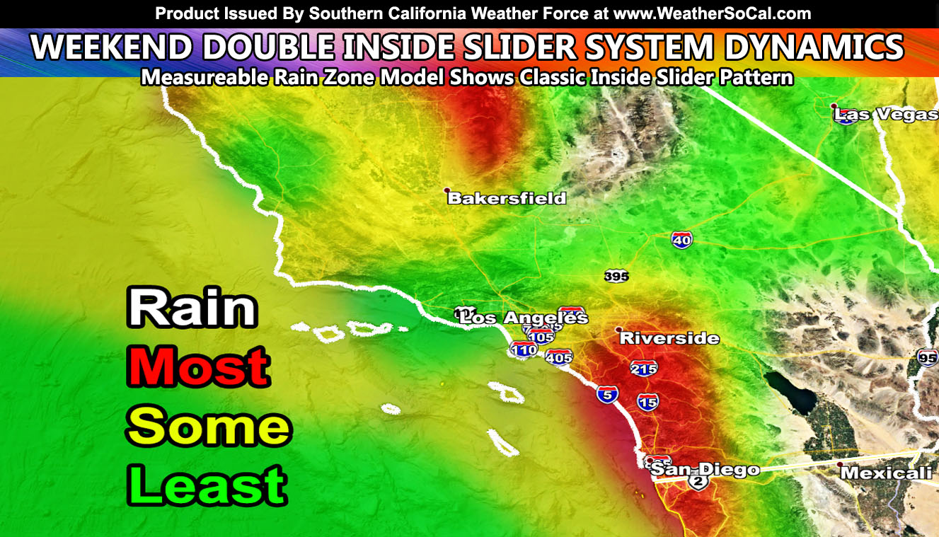
The rain zone model that detects what areas will see the best chances of measurable precipitation shows a classic inside slider pattern through the entire weekend and a good November 2020 outlook so for your location read on for details…
REMEMBER: Get these from the new app for notification – National Weather Force Android/IOS App notification system and you can find it here for free and never miss a post on this page again,
Download Today at – http://www.nationalweatherforce.com/2020/07/fb-weather-phone-app/
The first of the systems is expected to start in the Tehachapi Mountains by later Friday. As it moves closer to the southland, onshore flow will start hit and miss showers late Friday night across parts of OC/IE/San Diego with increasing showers through Saturday. This is expected to be the weaker of the two systems, the next one due on Sunday. That one has a strong west to east flow so with all inside sliders, the areas around Los Angeles will see less rain than areas in San Diego and the Inland Empire. Orographic lifting is strongest in the Eastern Inland Empire south to San Diego so this is where the most rain will hit over the weekend. Gusty wind conditions will also hit through the weekend and advisories will be needed in all metro areas.
Gusty winds will start in the mountain and desert regions as early as Friday, surfacing through the metros over the weekend. Over the day on Thursday you will see micro-climate alerts go out for this double system.
The snow-level will be between 4000-5000 FT. Inside sliders don’t bring a lot of snow to the LA/SBD/RIV/SAD Mountains, however it does bring a good amount to the Tehachapi Mountains, so this is going to be Tehachapi’s first snow.
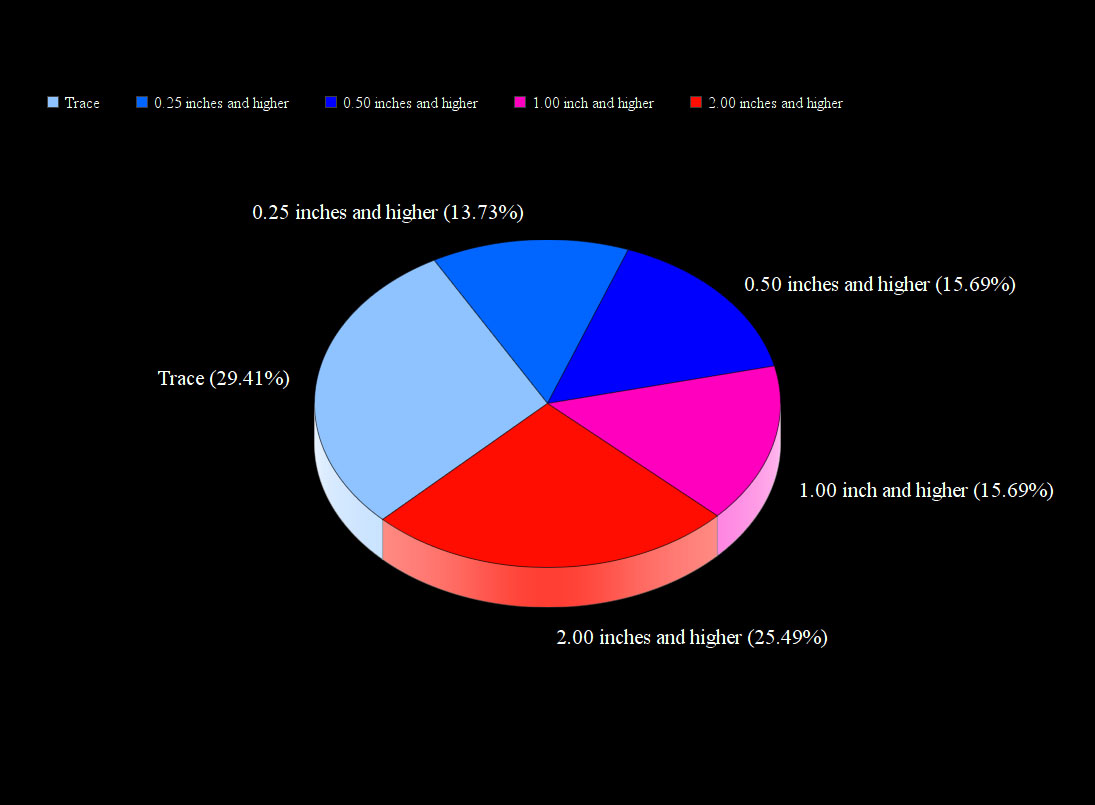
The rest of this month shows below average temperatures for the most part,, making it the colder November I said would be most likely. As a result, my final November 2020 Precipitation Pie Model shows Trace and 2.00+ inches or higher in the number 1 and 2 spot so we will see between a Trace and 2 inches of rain in Downtown Los Angeles this month along with colder than normal temperatures. There are indications that towards the end of the month into beginning December that the pattern becomes favorable for longwave troughs west of here,which ups the rainfall.
As always, stay tuned to Southern California Weather Force for official forecasts and updates in weather across Southern California
Join Southern California Weather Force main Facebook Page for future updates!
MICRO-CLIMATE ALERT FACEBOOK GROUPS: Find yours today!
Click here to join
Reading for another state? Join my national page – https://www.facebook.com/nwfweather/
FACEBOOK PAGES TO JOIN!
SOUTHERN CALIFORNIA WEATHER FORCE MAIN: Southern California Weather Force Office Main Page
NEWS REPORT BANDIT: Tired of Politics and Celebrities and want funny, interesting, weird stories, including science like solar storm, earthquake, volcano, space stories updated 1-2 times a day?
FOR THE CALIFORNIA FAULT STRESS MODEL PAGE: For SCWF official updates to the California Fault Stress Model and more!
PROJECT DESTINI WORLDWIDE QUAKE PREDICTION – A system that shows worldwide plate stress due to numerous factors
INSTAGRAM, TWITTER, and NOW TIKTOK SHORTS ACCOUNTS TO JOIN!
Instagram – https://www.instagram.com/socalweatherforce/
Twitter – https://twitter.com/SCweatherforce