

Issued Zones: All metro/coast/basin areas south and west of the mountains …
Site: Southern California Weather Force has issued a Storm Statement effective now for the weekend for Pacific Storm Asgard’s storms+strong wind dynamics …
Date: 11/5/20 at 8:50am PT
Forecast: A double-barreled storm system will impact the region over the weekend, bringing rain and gusty, sometimes damaging winds to the area, including the metro zones. Winds of this nature will be strong and thus when the official article does come out, Pacific Storm ASGARD will be officially named.
This system has been getting stronger with each passing 6-12 hour period and yesterday it looked a bit weaker overall, but today it looks stronger so it will have a name. I’ll start it at a category three today and if thunderstorms ‘continue’ to look possible it in the forecast area then it will be raised to category four. The storm will hit Saturday with rounds and then again on Sunday.
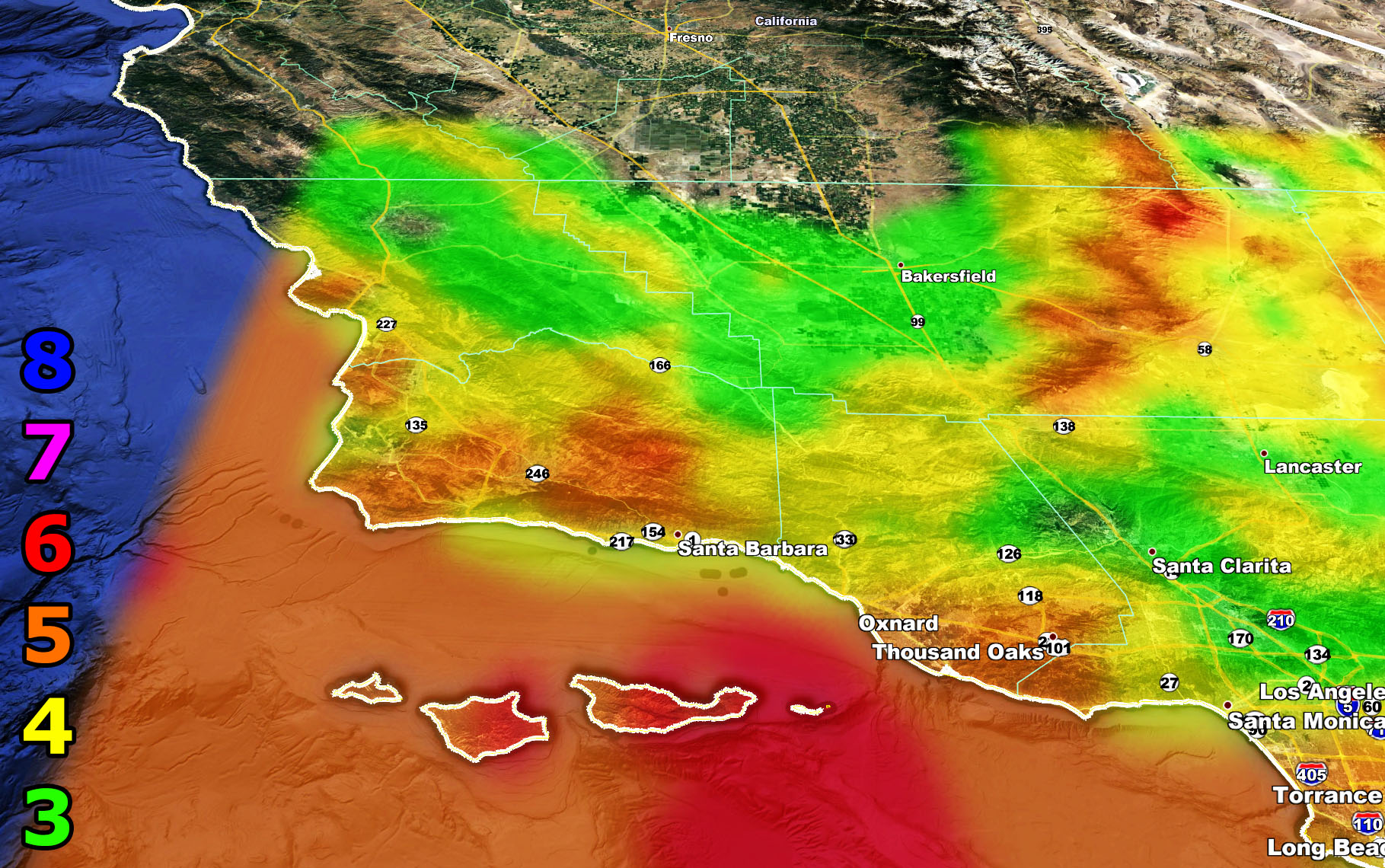
This system has multiple fronts with it so with each passing dynamic the wind will be strong out there. Some of the grids here at SCWF shows damaging winds in the metros with widespread intensity 4 and 5 wind gusts in the Storm Statement area. Look below to find your intensity the wind will surprise everyone in the metros because this forecast is not anywhere else so as long as you know and are reading this, you’re good to go. Flooding will be possible in spots south and west of the San Bernardino/Riverside/San Diego Mountains. Sliders like this tend to have a southwest to northeast low level flow favoring these areas so I’d prepare today for 1-2″ of rainfall in the El Dorado burn areas. Rainfall maps will be given out later on Friday on the SCWF Facebook Page.
8. Extensive widespread damage.
7. Trees are broken or uprooted, building damage is considerable. – High Profile Vehicle Roll-Over CERTAIN.
6. SOME Trees are broken or uprooted, building damage is possible. – High Profile Vehicle Roll-Over Likely, Do NOT recommend Traveling in this zone
5. Slight damage occurs to buildings, shingles are blown off of roofs. HIGH WIND WARNING CRITERIA – High Profile Vehicle Roll-Over Possible if weight is not corrected.
4. Twigs and small branches are broken from trees, walking is difficult. Anything 4 and above will have blowing dust if conditions are dry, which does reduce visibility and make driving difficult …
3. Large trees sway, becoming difficult to walk. POWER SHUTDOWN THRESHOLD during any high fire risk. WIND ADVISORY CRITERIA


Remember, you CAN get these by e-mail with discounts as a supporter as well. Find Southern California Weather Force in this link to learn how – https://www.southerncaliforniaweatherforce.com/weather-force-network-2020-2021-public-fundraiser-and-perks-page/ (100 percent delivery time)
Join A Micro-Climate Group On Facebook For These Alerts? (50 percent delivery time)
Click Here To Find Your Location Served By SCWF Today!
NOTE: If you read this from a SCWF micro-climate Facebook Group, keep in mind that forecast ARTICLES are NOT posted there unless it directly affects you. You will want to go to the MAIN SCWF Facebook Page and to go there you CLICK HERE.
10 mile rule: These alerts issued on this site means that within your zone and 10 miles from you will see the event forecast for. You may or may not see the event but it means you are in the zone or 10 miles from where someone will.
Forecaster: KM