
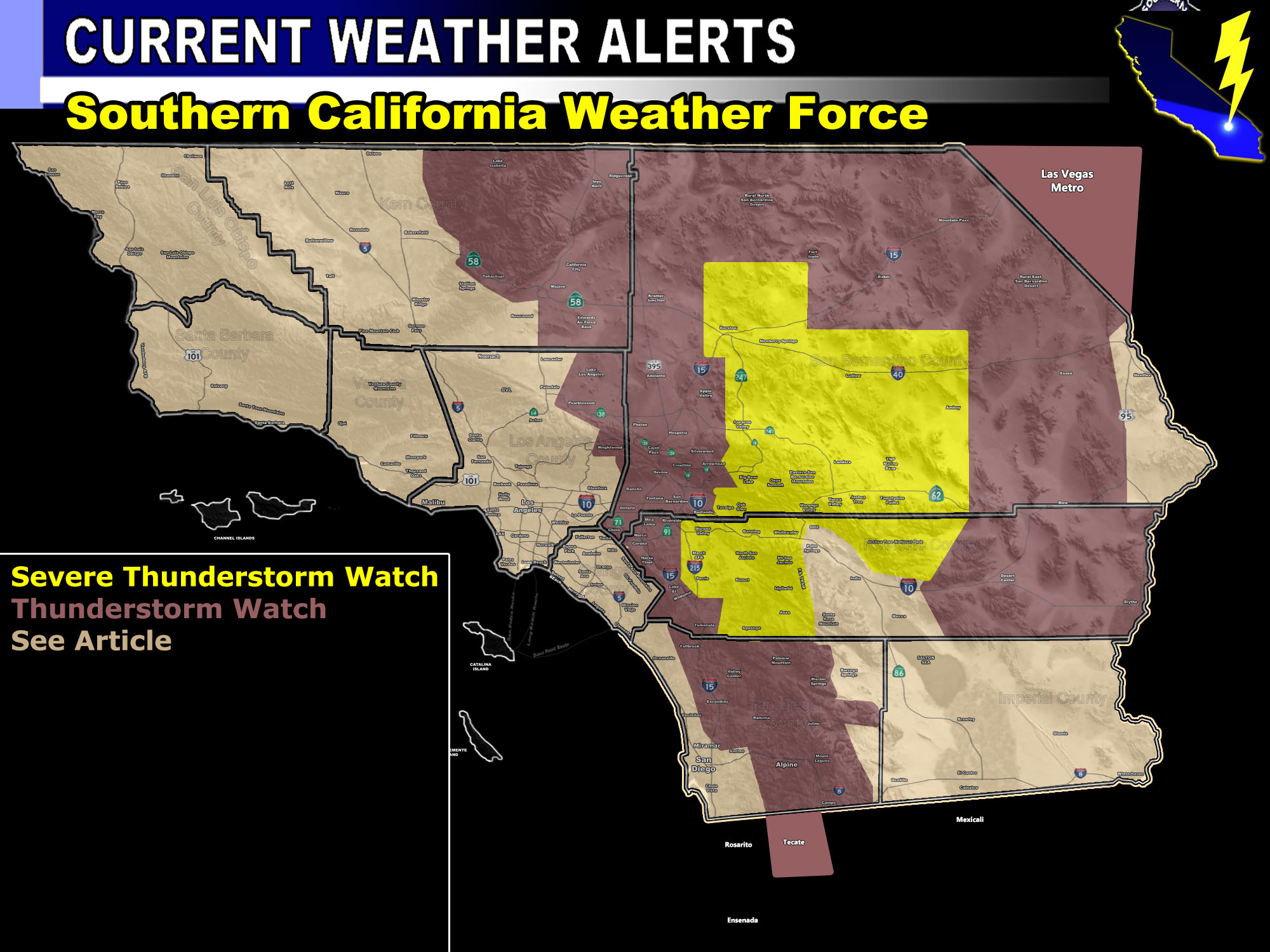
Issued Zones: Tecate … San Diego, Riverside, San Bernardino Mountains … Wrightwood …The Metro High Desert … The Inland Empire … San Diego Escondido to Fallbrook/Rainbow … Eastern Riverside and San Bernardino Deserts … Morongo Basin .. Las Vegas Metro .. .Kern Deserts and Northern Tehachapi Mountains …
Site: Southern California Weather Force has issued a Severe Thunderstorm Watch hybrid Thunderstorm Watch effective this afternoon through evening – This is a Flash Flood Watch embedded for the Oak Glen/Yucaipa burn scars.
Date: 9/9/21 at 9:40 am PT
Forecast: Short range models do not show what I am about to say so this is just going to be an interesting scenario. As per the video forecast I posted five days ago, we would see some sort of influx in monsoon moisture between a window from September 7th to the 12th or 13th … This window is today, the 9th, at the center of it so here is what looks to happen.
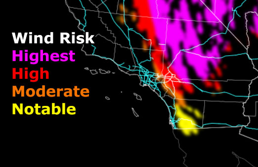
Southern California Weather Force thunderstorm model depicts storms firing over the mountains first and then outflow from them through the afternoon/evening will ignite the desert and inland valley areas. Instability is maximized over the Riverside and San Bernardino Mountains, north through Lucerne to Barstow and east into the Morongo Basin, with lead outflow for severity being possible in the Hemet zones as well.
Outflow could ignite the Elsinore Convergence zone and send activity through to the I-15 corridor from Corona to Ontario later in the period so this all needs to be monitored by you.
Outflow will play ping-pong out through the High Desert Metro as well, and I’m seeing “my phone app doesn’t show this” even in the High Desert … well your little appy-poo is wrong so throw it away …
Storms in the watch area will have damaging winds at times, the wind model shows where the worst can be with any stronger cells – Marginal severe hail is also likely in the thunderstorm watch zone, but the most severe will remain in the Severe Thunderstorm Watch area …
LANDSPOUT TORNADOES ARE POSSIBLE IN ANY OF THESE CELLS TODAY –
10 mile rule: These alerts issued on this site means that within your zone and 10 miles from you will see the event forecast for. You may or may not see the event but it means you are in the zone or 10 miles from where someone will.
Get these alerts via your own e-mail control panel for your zone, or the closest to you as a full supporting member of this service that saves lives and property – here – https://www.southerncaliforniaweatherforce.com/scwf-discount-member-sign-up-page
Join the Southern California Weather Force group for photos and pictures, and sometimes updates not posted on the main FB Page – here – https://www.facebook.com/groups/socalweatherforce/
See ALL Active articles and alerts for Southern California here – https://www.southerncaliforniaweatherforce.com
Southern California Weather Force is a custom weather alert service that began in September 1999 off and is regarded as the most accurate weather service in the region, offering custom alerts, maps, and models to help save life and property. The work done here is never 100% accurate, but it comes pretty close. Southern California Weather Force runs on zones, so if an event happens in a zone that is 10 miles from the border of your zone, the forecast is still valid to activate your zone’s alert system. A company quote to the public is that of “The Joker” and tells other agencies in weather this all the time… “This world deserves a better class of meteorologist… and I’m gonna give it to them”… out-forecasting even the National Weather Service with lead-time and precision, which makes this service a focus of ridicule and envy in the weather community due to having such accuracy. Alerts issued here are issued custom from this office and this office alone. You may not even hear it elsewhere, but if one is issued near or in your area, listen up because “if you do not wish to die in weather, follow, it’ll save your life one day.”