

Southern California Weather Force has upgraded the Santa Ana Wind Watch to Santa Ana Wind Advisory effective now through Saturday. The cutoff low will also nudge northward, affecting Ventura County westward as a result so read on for details and see the zoom-in SCWF model images for the wind event …
AD NOTE ( Not interested? Move down to “Article Start’): The Winter 2022 Tier for MEMBERS and ANYONE INTERESTED is OPEN FOR JANUARY THROUGH END FEBRUARY WITH REDUCED SEASONAL TIER RATES. This is when you get these delivered to your e-mail of choosing AND get your own micro-climate alert system based on your zone for my winter and storm alert products that are not posted on social media when issued. You also get the member section, which has controllable models like rain, wind, snow, in high resolution along with a GPS feature which is updated when an event is in the area –
CLICK HERE TO LEARN MORE AND SIGN-UP –
If you are a current member and NOT on a monthly plan, your Winter 2022 tier expires March 1st, but do not renew until the Spring 2022 tier is opened, which you’ll receive an email then.
ARTICLE START
The Santa Ana Winds will begin as early as mid this morning and increase through the day and night and into Saturday. The nominal Santa Ana Wind areas will all open up so if you are use to seeing them, you will see them. The wind models below will show who will see what and in what intensity.
Kern Mountains, you will see these strong winds, some areas stronger than the nominal Santa Ana Wind areas below passes and canyons…
What I will tell you is the stronger winds will have to wait till Saturday for the San Diego Mountains/Foothills/Valleys, including north into Temecula.
There’s zero way I can tell you zone by zone in a widespread event that has wind in one city and calm in another. You just need to use the images below.
Now, on Saturday, east winds into the surface low will be between 20-30 mph even in the OC/LA Basin and Coast to LAX. You may think it is strong since you are not use to them, but they will be below advisory level.
Cutoff Low: As for the cutoff system, we could see some drops in the low levels just about anywhere, but in all reality this is not a big system. For the final forecast, it has nudged slightly north, which means the closer zones to the center will be the ones that get more rain than others. This low is southwest of Santa Barbara, well southwest, which means Ventura,Santa Barbara, and San Luis Obispo stand the best chance of precipitation, most likely on Saturday. The rest, drops possible (who cares) and light rain (who cares) in higher elevation areas. I do not see activity in the High Desert at this time.
LONG RANGE: We start to see the Pacific become a bit more active after say January 24-25. This is when our best shot of actual storm activity to help bring January’s rainfall totals up some. So, if you don’t have your roof done by then, you may be out of luck. You have your outlook for the long range. It’s the best shot we have this month. I am not confident in strength at this time to issue a ‘long range weather advisory’ like I did last month. It just doesn’t have the kick I am looking for yet, but I am always monitoring.
I control 10 counties in Southern California so there is a lot to say for various areas. The best I can do is let the images below speak for themselves.
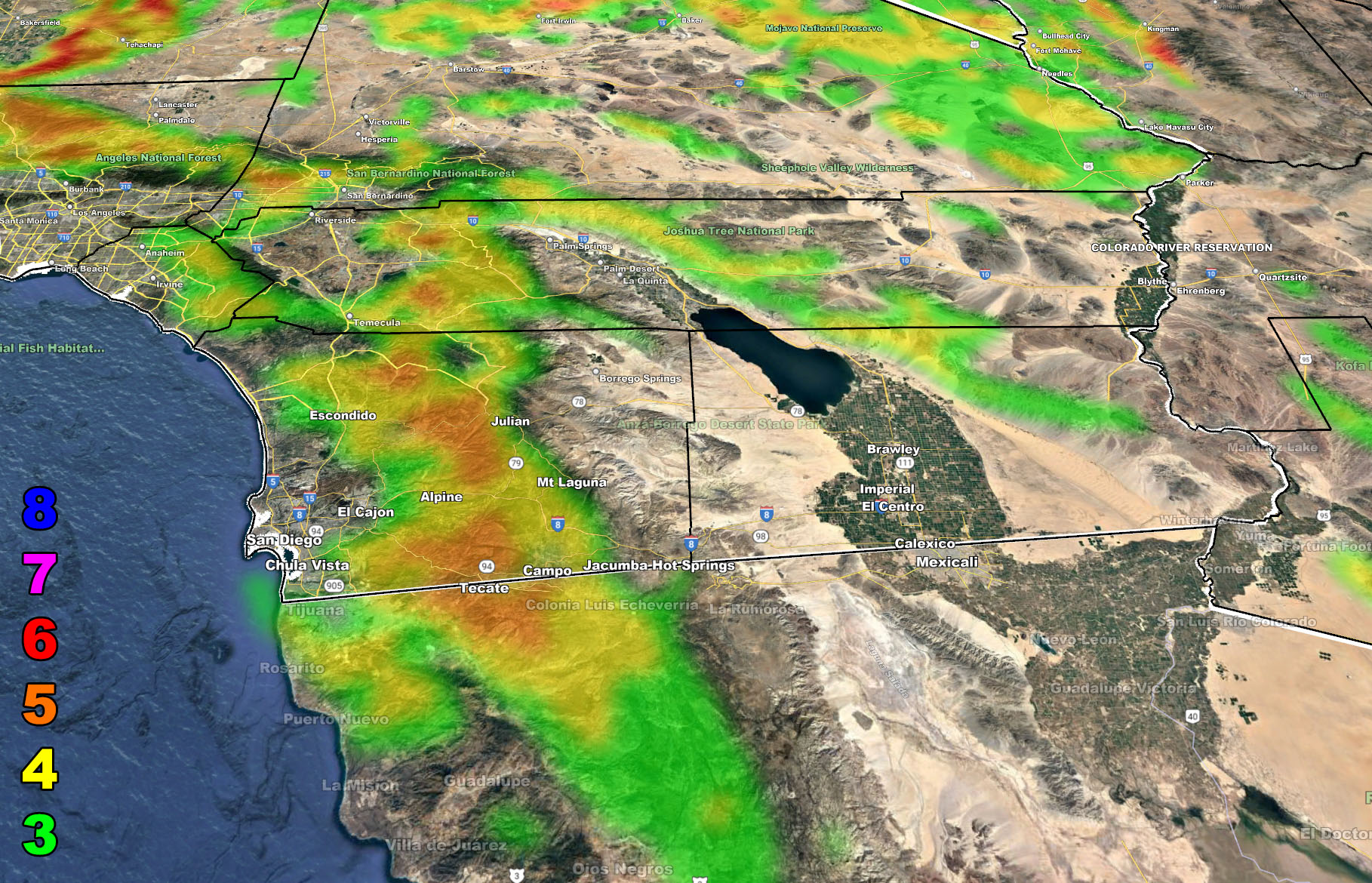
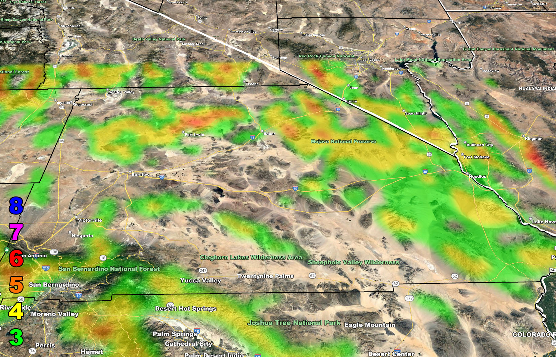
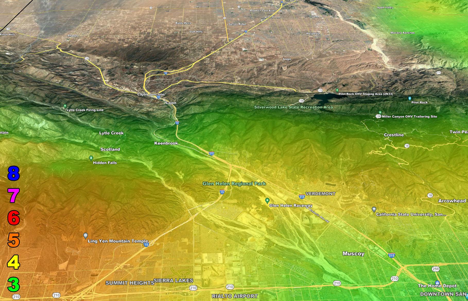
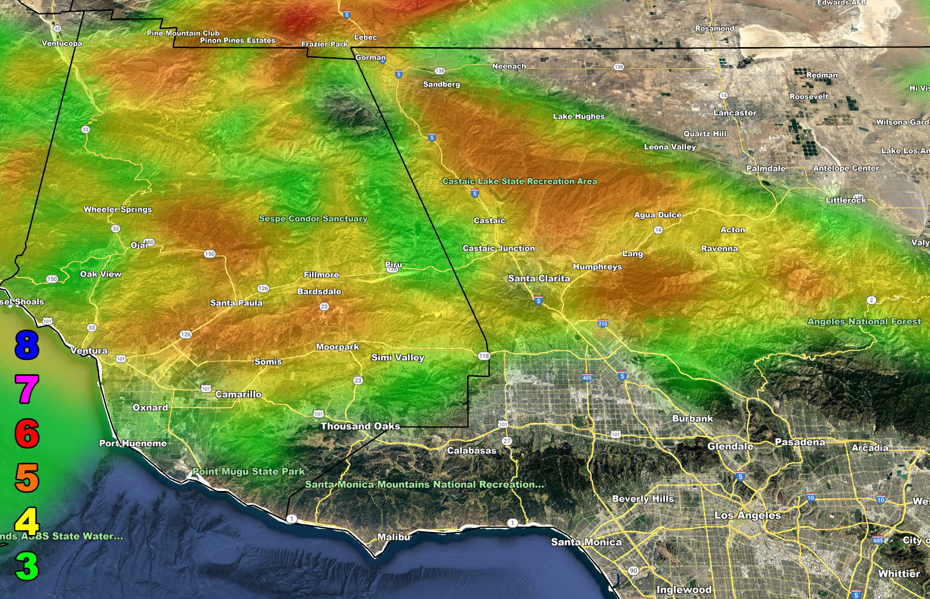
The maps below are of flood, rain, snow, snow-level, or wind intensity, whichever is available now. Each one is clickable. Map 1 is NW SoCal, Map 2 is SW SoCal, Map 3 is SE SoCal, Map 4 is NE SoCal, Map 5 is the Cajon Pass, and Map 6 is the SCV region, which includes Gorman at the top.
GET TO KNOW YOUR MAP BECAUSE THESE NEVER CHANGE LOCATIONS
Wind Forecast – Valid Today into Saturday, January 14-15, 2022 –
MEMBERS (Click Here To Open The GPS Version Of These Maps In The Member Section)
8. Extensive widespread damage.
7. Trees are broken or uprooted, building damage is considerable. – High Profile Vehicle Roll-Over CERTAIN.
6. SOME Trees are broken or uprooted, building damage is possible. – High Profile Vehicle Roll-Over Likely, Do NOT recommend Traveling in this zone
5. Slight damage occurs to buildings, shingles are blown off of roofs. HIGH WIND WARNING CRITERIA – High Profile Vehicle Roll-Over Possible if weight is not corrected.
4. Twigs and small branches are broken from trees, walking is difficult.
3. Large trees sway, becoming difficult to walk. POWER SHUTDOWN THRESHOLD WIND ADVISORY CRITERIA


ARTICLE END
How to get these alerts with a premium subscription via e-mail by micro-climate zone AND/OR Get the GPS models for all events on your device enabled? (100 percent delivery time)
Click Here To Join The Season Tier
Join The Main Southern California Weather Force Facebook Group (50 percent delivery time) – You can join the main SCWF page as well through that group.
Click Here To Join The Page Today
FACEBOOK PAGES TO JOIN!
SOUTHERN CALIFORNIA WEATHER FORCE MAIN: Southern California Weather Force Office Main Page
SOUTHERN CALIFORNIA WEATHER FORCE METEOROLOGIST: – Just my public figure page that isn’t as large so maybe you can reach me better at times.
INSTAGRAM, TWITTER, TO JOIN!
Instagram – https://www.instagram.com/socalweatherforce/
Twitter – https://twitter.com/SCweatherforce
Southern California Weather Force is a custom weather alert service that began in September 1999 off and is regarded as the most accurate weather service in the region, offering custom alerts, maps, and models to help save life and property. The work done here is never 100% accurate, but it comes pretty close. Southern California Weather Force runs on zones, so if an event happens in a zone that is 10 miles from the border of your zone, the forecast is still valid to activate your zone’s alert system. A company quote to the public is that of “The Joker” and tells other agencies in weather this all the time… “This world deserves a better class of meteorologist… and I’m gonna give it to them”… out-forecasting even the National Weather Service with lead-time and precision, which makes this service a focus of ridicule and envy in the weather community due to having such accuracy. Alerts issued here are issued custom from this office and this office alone. You may not even hear it elsewhere, but if one is issued near or in your area, listen up because “if you do not wish to die in weather, follow, it’ll save your life one day.”